

View Information About HSR Ratings
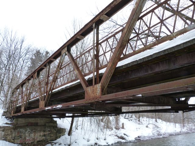
This bridge is a pony truss bridge with riveted connections. It is noted for its unusual variation of lattice railing. It currently serves non-motorized traffic in the form of the Chesley Heritage Trail. However, this is not a case where a heritage bridge was relocated to serve a trail. The bridge sits on very old concrete abutments demonstrating that the bridge was here long before the trail. It does not appear that this bridge has served vehicular traffic for a very long time, but it does appear that there was a road at this location long ago.
The truss superstructure appears to remain in good condition and more than sufficient for the trail use of the bridge, however the abutments are slowly deteriorating, with some scour, presumably caused during floods, noted on the north abutment. Recommended future preservation work would be to repair the abutments to prevent further deterioration.
This bridge is today distinguished as the last pony truss in Chesley. Chesley used to have another truss bridge a short distance west of this bridge on Thomas Street, however a shortsighted decision was made to demolish this bridge, located on a quiet local street, and replace it with an ugly slab of concrete rather than restore the bridge for light vehicular use. The Thomas Street Bridge was a four panel pin-connected full-slope pony truss. While Bruce County has an impressive and unusually large surviving population of truss bridges with heritage value, nearly all of them have riveted connections. Pin-connected truss bridges are an older design of truss bridge, and are very rare in Ontario. Even if insufficient for the light traffic that Thomas Street carries, the heritage bridge could have been relocated and preserved for non-motorized use elsewhere.
Having failed to preserve the Thomas Street Bridge, the remaining truss bridge is now the last of its kind in Chesley and hopefully the community will recognize this bridge as its last chance to preserve this beautiful type of heritage bridge in their community.
![]()
![]()
![]()
Coordinates (Latitude, Longitude):
Search For Additional Bridge Listings:
Additional Maps:
Google Streetview (If Available)
GeoHack (Additional Links and Coordinates)
Apple Maps (Via DuckDuckGo Search)
Apple Maps (Apple devices only)
Android: Open Location In Your Map or GPS App
Flickr Gallery (Find Nearby Photos)
Wikimedia Commons (Find Nearby Photos)
Directions Via Sygic For Android
Directions Via Sygic For iOS and Android Dolphin Browser

© Copyright 2003-2024, HistoricBridges.org. All Rights Reserved. Disclaimer: HistoricBridges.org is a volunteer group of private citizens. HistoricBridges.org is NOT a government agency, does not represent or work with any governmental agencies, nor is it in any way associated with any government agency or any non-profit organization. While we strive for accuracy in our factual content, HistoricBridges.org offers no guarantee of accuracy. Information is provided "as is" without warranty of any kind, either expressed or implied. Information could include technical inaccuracies or errors of omission. Opinions and commentary are the opinions of the respective HistoricBridges.org member who made them and do not necessarily represent the views of anyone else, including any outside photographers whose images may appear on the page in which the commentary appears. HistoricBridges.org does not bear any responsibility for any consequences resulting from the use of this or any other HistoricBridges.org information. Owners and users of bridges have the responsibility of correctly following all applicable laws, rules, and regulations, regardless of any HistoricBridges.org information.
![]()