

View Information About HSR Ratings
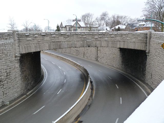
A major part of Ontario's history of bridge construction revolves around concrete rigid-frame bridges. Shortly after the bridge type was invented around 1930, Ontario began building the bridge in large quantities, both for water crossings and also for highway overpasses. The rigid frame bridge is one of the most common types of pre-1970 bridges in Ontario, something that is not true elsewhere. In the neighboring state of Michigan, rigid-frame bridges are downright rare. In neighboring New York State, rigid-frame bridges are usually confined to early limited access highway (expressway) overpasses. It is in this history that the Victoria Avenue Bridge has a connection. When the first limited access highways began to be built in the 1930s in places like New York City, Connecticut's Merritt Parkway, and the Pennsylvania Turnpike, the rigid-frame bridge was found to be well-suited for overpasses on these highways. New York City and Connecticut frequently faced these overpasses in stone to make them look attractive. A number of these overpasses still survive today. Oddly, as popular as rigid-frames are in Ontario, the practice of facing them in stone never appears to have taken root in the province. The Victoria Avenue Bridge, one of the oldest rigid-frame overpasses in Ontario with a 1941 construction date, is also the only stone faced rigid frame overpass in the entire province. As such, it is one of the most important rigid frame heritage bridges in Ontario. In addition to the stone facing, the bridge also has a keystone with a sculpture of a crown on it. There is more than just the bridge itself to look at here. The King's Highway 420 passes under Victoria Avenue Bridge as a depressed roadway. As such, there was the need for large retaining walls on either side of the highway, and these also are faced in the same type of stone. Special stone pedestals on this wall provide mounts for lighting. The highway is on a curve as it passes under the bridge which adds a further visual dynamic to the setting. The setting is that of a sweeping curve of beautiful stonework with the stone faced bridge being the centerpiece of it all.
With the King's Highway 420 being the way that the many Niagara Falls visitors enter the area, and the overpass only a short distance from downtown Niagara Falls and the Falls themselves, this overpass is a beautiful gateway into Niagara Falls.
![]()
![]()
![]()
Coordinates (Latitude, Longitude):
Search For Additional Bridge Listings:
Additional Maps:
Google Streetview (If Available)
GeoHack (Additional Links and Coordinates)
Apple Maps (Via DuckDuckGo Search)
Apple Maps (Apple devices only)
Android: Open Location In Your Map or GPS App
Flickr Gallery (Find Nearby Photos)
Wikimedia Commons (Find Nearby Photos)
Directions Via Sygic For Android
Directions Via Sygic For iOS and Android Dolphin Browser

© Copyright 2003-2024, HistoricBridges.org. All Rights Reserved. Disclaimer: HistoricBridges.org is a volunteer group of private citizens. HistoricBridges.org is NOT a government agency, does not represent or work with any governmental agencies, nor is it in any way associated with any government agency or any non-profit organization. While we strive for accuracy in our factual content, HistoricBridges.org offers no guarantee of accuracy. Information is provided "as is" without warranty of any kind, either expressed or implied. Information could include technical inaccuracies or errors of omission. Opinions and commentary are the opinions of the respective HistoricBridges.org member who made them and do not necessarily represent the views of anyone else, including any outside photographers whose images may appear on the page in which the commentary appears. HistoricBridges.org does not bear any responsibility for any consequences resulting from the use of this or any other HistoricBridges.org information. Owners and users of bridges have the responsibility of correctly following all applicable laws, rules, and regulations, regardless of any HistoricBridges.org information.
![]()