

View Information About HSR Ratings
The owner of land around this bridge contacted HistoricBridges.org and asked that we pass on the following: The bridge is actually on private property and we'd prefer people respect that and stay on the highway. We had a survey semi-recently to confirm this and we've had constant issues with trespassers including an assault.
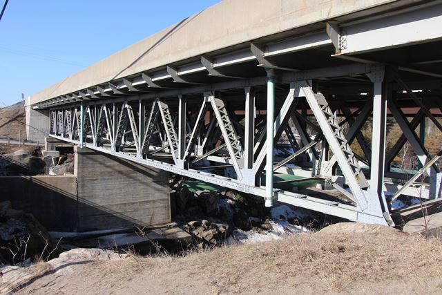
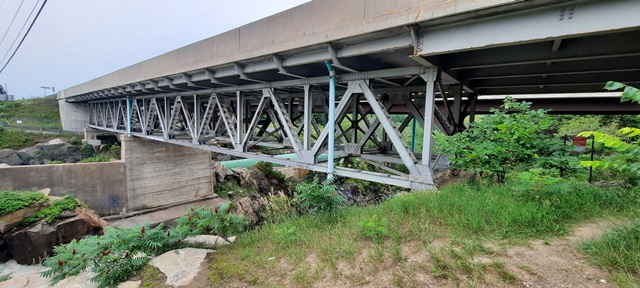
This bridge is a riveted deck truss bridge that carries heavy King's Highway traffic. a number of rivets have been replaced with bolts as part of repairs, but given the heavy use the bridge retains good historic integrity overall. Deck truss bridges are uncommon, making this a noteworthy, if late, example of its type. The two deck truss spans are not the same length; the northern span is longer.
The location of this bridge is over a narrow, rocky gorge and waterfall, making it an interesting site to say the least.
This bridge originally carried two way traffic, but today a steel rigid-frame bridge carries southbound traffic while the heritage bridge carries northbound traffic. According to thekingshighway.ca/ the southbound bridge (and one-way pair conversion) occurred in 1974.
This bridge is tagged with the following special condition(s): Unorganized Photos
![]()
![]()
![]()
![]()
![]()
Coordinates (Latitude, Longitude):
Search For Additional Bridge Listings:
Additional Maps:
Google Streetview (If Available)
GeoHack (Additional Links and Coordinates)
Apple Maps (Via DuckDuckGo Search)
Apple Maps (Apple devices only)
Android: Open Location In Your Map or GPS App
Flickr Gallery (Find Nearby Photos)
Wikimedia Commons (Find Nearby Photos)
Directions Via Sygic For Android
Directions Via Sygic For iOS and Android Dolphin Browser

© Copyright 2003-2024, HistoricBridges.org. All Rights Reserved. Disclaimer: HistoricBridges.org is a volunteer group of private citizens. HistoricBridges.org is NOT a government agency, does not represent or work with any governmental agencies, nor is it in any way associated with any government agency or any non-profit organization. While we strive for accuracy in our factual content, HistoricBridges.org offers no guarantee of accuracy. Information is provided "as is" without warranty of any kind, either expressed or implied. Information could include technical inaccuracies or errors of omission. Opinions and commentary are the opinions of the respective HistoricBridges.org member who made them and do not necessarily represent the views of anyone else, including any outside photographers whose images may appear on the page in which the commentary appears. HistoricBridges.org does not bear any responsibility for any consequences resulting from the use of this or any other HistoricBridges.org information. Owners and users of bridges have the responsibility of correctly following all applicable laws, rules, and regulations, regardless of any HistoricBridges.org information.
![]()