

View Information About HSR Ratings

This landmark bridge provides the only vehicular and pedestrian access to Belle Isle, which has traditionally been the premier public park of Detroit.

This crossing has an interesting history. The first bridge was a bridge composed of pin-connected through truss spans. One of the spans was a through truss swing span. The bridge was completed in 1889. The photo above, from the Library of Congress, shows the ornate portal this bridge had.
Sometime between 1889 and 1899, a timber trestle approach system was replaced with five rivet-connected Warren pony truss spans. One of these spans was relocated, reused, and survives to this day on Grosse Ile. Please visit the Swan Drive Bridge webpage to see this span, and also to see and read additional history about this former Belle Isle Bridge.

In 1915, the creosote blocks that formed the deck of the bridge caught fire sending the bridge up into a blaze. The heat was so great it affected not only the metal of the truss, but the stone piers as well, and caused the bridge to collapse.
Following the collapse, a temporary bridge was completed in July 1916. Primarily a simple timber structure, but also reusing the five pony truss spans which were not destroyed in the fire, it also included a steel bascule span to accommodate boats. The Scherzer Rolling Lift Bridge Company of Chicago had presented the city with two options for a temporary bascule (using the company's patented rolling lift design): a single leaf truss bascule, and a double leaf deck girder bascule. It appears the city selected the deck girder bascule.


Detroit also began planning for a new permanent bridge after the truss bridge collapsed. The planning process involved a lot of effort, discussion, and debate. Some proposals were for a traditional concrete arch bridge, and even included a proposal by Daniel Luten, who was a noted Indiana engineer and patent-holder for a design of reinforced concrete arch bridge. Architect, city planner, and co-author of the famous Plan of Chicago, Edward Bennett, produced for Detroit an early proposal for a concrete arch bridge to Belle Isle in 1915. Historical articles and reports refer to some drawings and plans that are different from what the final product actually ended up being showing that the debate was highly publicized.

However, Detroit was uncomfortable with a traditional concrete arch design because of concerns the soil conditions would not support the thrust forces from such a bridge.
In response to the soil concerns, a proposal for an exceedingly rare and unusual type of bridge was proposed that would visually look like a concrete arch bridge, but would in terms of function act as cantilever arms extending from each pier. This type of bridge would transmit forces to the piers in a way that would be compatible with the soil conditions. Even this initial design was not without debate, discussion, and revision, as the initial proposal was so expensive that their were concerns about the cost. The final product itself was designed by a University of Michigan professor, Lewis Merritt Gram. Gram also was involved with the initial design of the Michigan Stadium.

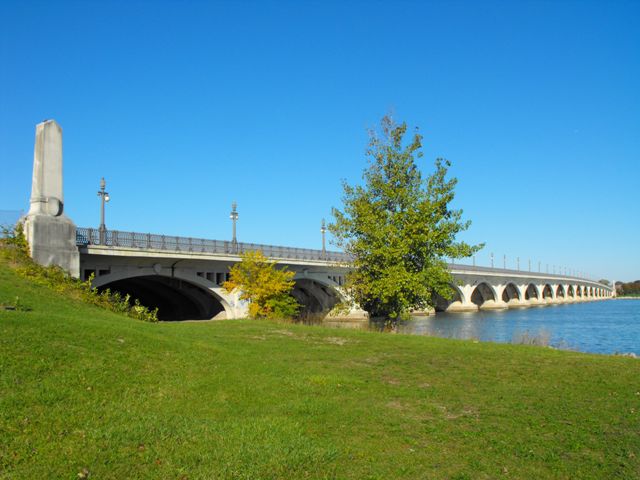
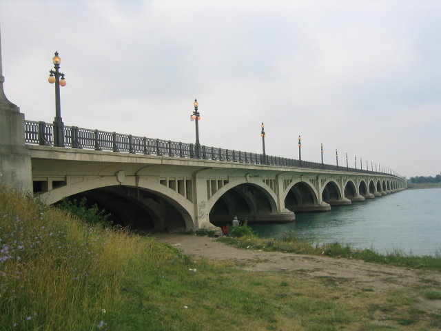
This is an extremely long multi-span concrete arch bridge that gives people access to Belle Isle, and the structure is the longest arch bridge in the state of Michigan.
This bridge is extremely significant not only because of its length, but because it is a very early example of a cantilevered concrete arch. A cantilevered concrete arch does not function like a traditional arch. In fact, many engineering articles discussing this bridge are careful to NOT call the bridge a concrete arch, and instead describe the bridge as an arch-shaped cantilever bridge. Traditional arch bridges require the arch to be a complete and connected structure to function and they have forces that thrust into the piers and abutments, something this bridge was specifically designed to avoid. With this bridge, each half of each arch span is a cantilever arm that is structurally independent from the other half of the arch in that span. Standing under a span of this bridge, a clear gap at the center of the span is visible. Indeed, on the outermost part of the arch, a decorative "keystone" was placed for aesthetic reasons to cover up this gap. Above this gap, a short concrete suspended span connects the two cantilever arms. Period texts described this bridge's units of two arms extending from each pier as "umbrellas" and this description might help to visualize how the different parts are arranged.
The internal reinforcing for this bridge is very complex, reflective of the unusual cantilever design. While traditional rebar is a part of the bridge's concrete, at the core of the bridge's cantilevered arch ribs (the cantilever arms) are heavy riveted steel trusses. Even more unusual, an eyebar stay system connects the end of these cantilever arms back to the top of the piers, adding strength to these cantilever arms.

The ornamental sidewalk railings on this bridge are either original or they replicate the original design. Today, vehicular traffic is kept at bay via modern New Jersey barriers, which MDOT mentions were added in 1985. Obviously, this bridge goes over the side of the Detroit River that freighters do not use, which accounts for why a low-clearance bridge was built here. The earlier bridges at this location required a movable bridge for boats, but apparently by the time this bridge was built, large boats were only using the channel on the other side of the island.

A 1918 copy of a book entitled "Concrete engineers' handbook: data for the design and construction of plain and reinforced concrete structures" by George A. Hool et al. lists several bridges using this design, including an additional unidentified example in Wayne County, and the Hopple Street Viaduct in Cincinnati (now demolished). As such, the Belle Isle Bride may not be the second example of its kind as sometimes is claimed, but is still an early example, and is without a doubt the largest and most technologically complex example of a concrete cantilever deck arch bridge. The other large example is the 7th Street Bridge in Modesto, California. The Modesto example has a simpler reinforcing design that does not appear to include the large eyebar stays found inside the Belle Isle Bridge.
Wayne County Road Commission was among Michigan's counties, an innovative and creative road commission and they apparently made significant use of concrete cantilever arch structures. Other examples of concrete cantilever bridges in the county remain. These other examples are different from the Belle Isle Bridge, and feature a more visually integrated suspended span between the cantilever arms. These smaller bridges also are likely less complex in terms of their reinforcing design. The Parke Lane Bridge is one of the best examples of these bridges.
Plaques for the bridge are located on the mainland end of the bridge. The plaques are shown below.

Above: Original plaque. Photo Credit: C. Hanchey

Above: Rehabilitation plaque. Photo Credit: C. Hanchey
Information and Findings From Michigan Historic Bridge InventoryNarrative Description This monumental structure consists of nineteen spans, with a total
length of 2,356 feet. It features cantilevered arches, allegedly only
the second example of a bridge of this type in the United States when it
opened. The city of Detroit completed a major rehabilitation of this
bridge in 1984-1985, at a cost of $11.4 million. The project included
repairs to the arches, an entirely new deck and road surface, and the
installation of "New Jersey barriers" between the roadway and sidewalk.
|
This bridge is tagged with the following special condition(s): Unorganized Photos
![]()
![]()
![]()
![]()
![]()
![]()
Coordinates (Latitude, Longitude):
Search For Additional Bridge Listings:
Bridgehunter.com: View listed bridges within 0.5 miles (0.8 kilometers) of this bridge.
Bridgehunter.com: View listed bridges within 10 miles (16 kilometers) of this bridge.
Additional Maps:
Google Streetview (If Available)
GeoHack (Additional Links and Coordinates)
Apple Maps (Via DuckDuckGo Search)
Apple Maps (Apple devices only)
Android: Open Location In Your Map or GPS App
Flickr Gallery (Find Nearby Photos)
Wikimedia Commons (Find Nearby Photos)
Directions Via Sygic For Android
Directions Via Sygic For iOS and Android Dolphin Browser
USGS National Map (United States Only)
Historical USGS Topo Maps (United States Only)
Historic Aerials (United States Only)
CalTopo Maps (United States Only)

© Copyright 2003-2024, HistoricBridges.org. All Rights Reserved. Disclaimer: HistoricBridges.org is a volunteer group of private citizens. HistoricBridges.org is NOT a government agency, does not represent or work with any governmental agencies, nor is it in any way associated with any government agency or any non-profit organization. While we strive for accuracy in our factual content, HistoricBridges.org offers no guarantee of accuracy. Information is provided "as is" without warranty of any kind, either expressed or implied. Information could include technical inaccuracies or errors of omission. Opinions and commentary are the opinions of the respective HistoricBridges.org member who made them and do not necessarily represent the views of anyone else, including any outside photographers whose images may appear on the page in which the commentary appears. HistoricBridges.org does not bear any responsibility for any consequences resulting from the use of this or any other HistoricBridges.org information. Owners and users of bridges have the responsibility of correctly following all applicable laws, rules, and regulations, regardless of any HistoricBridges.org information.
![]()