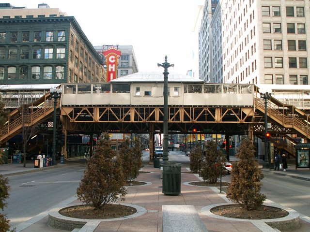
Most people probably do not think of the
Chicago's elevated railroad transit system, commonly called "The L", as a bridge, but
much of it is in fact a giant, continuous grade separation... a very long bridge that winds through the city. Most sections of the "L" consist of either Warren deck truss spans or deck plate girder spans, and these spans are generally
supported by steel bents, which sometimes have rather elaborate designs to make them fit into the city and work to support the "L" and its stations properly. Both substructure and superstructure are composed of riveted steel, and built-up
beams are frequently employed on the bents. The central core of the system in the Loop consists of the Warren deck truss spans. Much of the elevated railroad system has a great deal of historic value, despite widespread and continuing
alterations to the original design and materials. Different parts of the system were originally owned by different companies, and today these are all unified under Chicago Transit Authority (CTA) ownership. Parts of this elevated rail
system
are extremely old, dating to around 1895, those sections being among the oldest elevated rail lines
in the world. Others sections are newer, or have been replaced with new steel
beam structures. The stations for the Chicago "L" tend to be the most heavily altered parts of the system. Many historic stations have been demolished and replaced. However, many historic stations also remain, and despite alterations,
are important visual reminder's to Chicago's long history of providing light rail transportation to its residents and visitors. Chicago actually partially owes its extremely dense urban core of skyscrapers to the "L" which enabled
unusually large numbers of people to easily access the downtown area. The Chicago "L" gets across the Chicago River via the Wells Street Bridge and the
Lake Street Bridge. The section of
railroad that
runs over Wells Street south of the Wells Street Bridge is really interesting,
and retains a great deal of historic integrity.
Additional HistoricBridges.org "L" Coverage
Some segments of the Chicago "L," passing over more significant obstacles, are larger and stray enough from the usual sections of "L" that they warranted consideration as individual bridges. As such, they have been listed as individual
bridges and given their own Bridge Browser Page. The following is a list of links to those structures.
Original / Full Size Photos An assortment of photos that show various trackage, supports, and details. This gallery offers photos in the highest available resolution and file size in a touch-friendly popup viewer. Alternatively, Browse Without Using Viewer
Mobile Optimized Photos An assortment of photos that show various trackage, supports, and details. This gallery features data-friendly, fast-loading photos in a touch-friendly popup viewer. Alternatively, Browse Without Using Viewer
Original / Full Size Photos Built in 1895, this is one of the oldest stations on the system and despite alteration retains several unique details including ornate railings and supports with cast details. Overview and detail photos of the station. This gallery offers photos in the highest available resolution and file size in a touch-friendly popup viewer. Alternatively, Browse Without Using Viewer
Mobile Optimized Photos Built in 1895, this is one of the oldest stations on the system and despite alteration retains several unique details including ornate railings and supports with cast details. Overview and detail photos of the station. This gallery features data-friendly, fast-loading photos in a touch-friendly popup viewer. Alternatively, Browse Without Using Viewer
Original / Full Size Photos This station was built in 1897 and is one of the only stations that has been officially designated as historic and has been preserved with an eye toward maintaining its historic appearance. Overview and detail photos of the station. This gallery offers photos in the highest available resolution and file size in a touch-friendly popup viewer. Alternatively, Browse Without Using Viewer
Mobile Optimized Photos This station was built in 1897 and is one of the only stations that has been officially designated as historic and has been preserved with an eye toward maintaining its historic appearance. Overview and detail photos of the station. This gallery features data-friendly, fast-loading photos in a touch-friendly popup viewer. Alternatively, Browse Without Using Viewer
Original / Full Size Photos Overview and detail photos of the station. This gallery offers photos in the highest available resolution and file size in a touch-friendly popup viewer. Alternatively, Browse Without Using Viewer
Mobile Optimized Photos Overview and detail photos of the station. This gallery features data-friendly, fast-loading photos in a touch-friendly popup viewer. Alternatively, Browse Without Using Viewer
Original / Full Size Photos Trackage, supports, and details in the vicinity of Illinois Institute of Technology. This gallery offers photos in the highest available resolution and file size in a touch-friendly popup viewer. Alternatively, Browse Without Using Viewer
Mobile Optimized Photos Trackage, supports, and details in the vicinity of Illinois Institute of Technology. This gallery features data-friendly, fast-loading photos in a touch-friendly popup viewer. Alternatively, Browse Without Using Viewer
Original / Full Size Photos Overview and detail photos of the station. This gallery offers photos in the highest available resolution and file size in a touch-friendly popup viewer. Alternatively, Browse Without Using Viewer
Mobile Optimized Photos Overview and detail photos of the station. This gallery features data-friendly, fast-loading photos in a touch-friendly popup viewer. Alternatively, Browse Without Using Viewer
Maps and Links: Chicago Transit Authority "L" System