

View Information About HSR Ratings
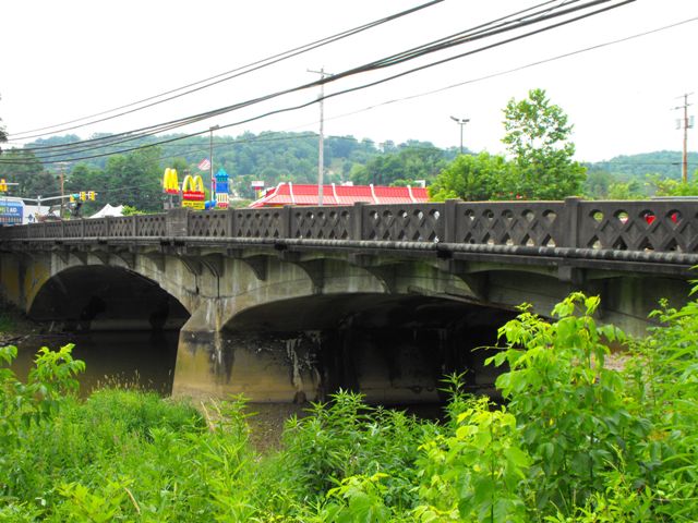
This is an attractive two span concrete deck arch bridge, whose most unusual and noteworthy feature is its beautiful railings. Two rows of pierced teardrop shapes and a single row of inset diamond shapes form an unusual but highly attractive lattice-like pattern on the railings of this bridge. The bridge retains good historic integrity, however the roadway is extremely busy carrying large volumes of traffic for a bridge with two travel lanes. As such, this historic bridge may be at risk for demolition.
Information and Findings From Pennsylvania's Historic Bridge InventoryDiscussion of Bridge The 1928, 2 span (2 @ 75'), reinforced concrete elliptical deck arch bridge with a concrete pier and abutments is finished with cantilevered deck sections and custom balustrades with tear drop- shaped openings flanking a diamond panel. The balustrades are a county design that was used on other arch bridges from the same period. This example is complete, but it is does not have long span lengths, and it is not an early example of its technology, which was common by 1910. The bridge is not historically or technologically significant. It is an example of a design that takes advantage of the moldable qualities of concrete. Discussion of Surrounding Area The bridge carries a 2 lane state road with 2 sidewalks over a stream in an area dominated by a mix of mid- to late-20th century commercial development in Morrisville. Two active tracks of the Monongahela Railroad cross SR 19 on an overpass approximately 200' west of the bridge. The area does not have historic district potential. Bridge Considered Historic By Survey: No |
![]()
![]()
![]()
This historic bridge has been demolished. This map is shown for reference purposes only.
Coordinates (Latitude, Longitude):
Search For Additional Bridge Listings:
Bridgehunter.com: View listed bridges within 0.5 miles (0.8 kilometers) of this bridge.
Bridgehunter.com: View listed bridges within 10 miles (16 kilometers) of this bridge.
Additional Maps:
Google Streetview (If Available)
GeoHack (Additional Links and Coordinates)
Apple Maps (Via DuckDuckGo Search)
Apple Maps (Apple devices only)
Android: Open Location In Your Map or GPS App
Flickr Gallery (Find Nearby Photos)
Wikimedia Commons (Find Nearby Photos)
Directions Via Sygic For Android
Directions Via Sygic For iOS and Android Dolphin Browser
USGS National Map (United States Only)
Historical USGS Topo Maps (United States Only)
Historic Aerials (United States Only)
CalTopo Maps (United States Only)

© Copyright 2003-2026, HistoricBridges.org. All Rights Reserved. Disclaimer: HistoricBridges.org is a volunteer group of private citizens. HistoricBridges.org is NOT a government agency, does not represent or work with any governmental agencies, nor is it in any way associated with any government agency or any non-profit organization. While we strive for accuracy in our factual content, HistoricBridges.org offers no guarantee of accuracy. Information is provided "as is" without warranty of any kind, either expressed or implied. Information could include technical inaccuracies or errors of omission. Opinions and commentary are the opinions of the respective HistoricBridges.org member who made them and do not necessarily represent the views of anyone else, including any outside photographers whose images may appear on the page in which the commentary appears. HistoricBridges.org does not bear any responsibility for any consequences resulting from the use of this or any other HistoricBridges.org information. Owners and users of bridges have the responsibility of correctly following all applicable laws, rules, and regulations, regardless of any HistoricBridges.org information.
![]()