

View Information About HSR Ratings
The name of this road the bridge is on varies based on what map you look at. The name Green Bridge may be a more recent nickname based on the paint color of this bridge. The Kiefel Bridge name is likely the more historic name.
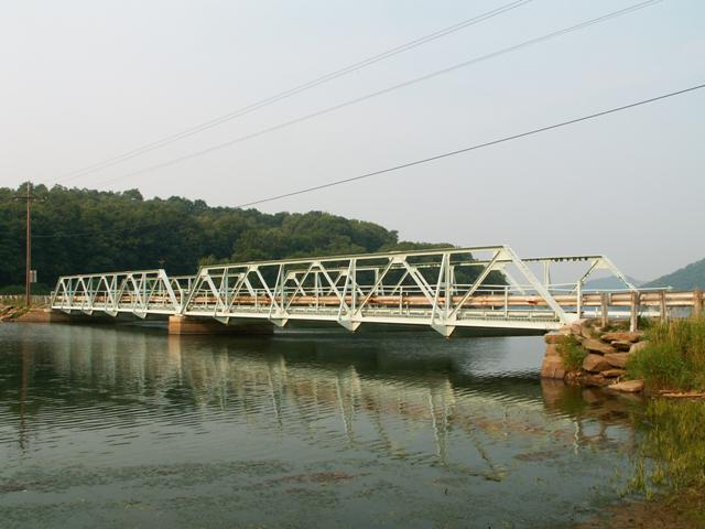
The bridge is a a two-span Warren pony truss. The trusses are composed of riveted angles, either paired or single, which form a relatively lightweight and simple truss. Floorbeams are rolled American Standard Beam i-beams. The bridge currently is fitted with a open steel grate deck that rests on steel stringers. One side of the deck has metal plate welded to it to function as a sidewalk. One pipe railing runs along each truss, which is part of the original railing The other part has been removed to make way for modern Armco style guardrail.
Pony truss bridges composed of members and chords that were riveted angles were common in Michigan and Ontario in the earlier 20th century. They were an alternative to the more massive and common truss bridges with built-up box beam top chords. Relatively fewer examples of this design appear to remain in Pennsylvania. This bridge is significant as an example of the light weight truss form, for having good historic integrity, and for coming in an uncommon multi-span configuration. Multi-span pony trusses are usually uncommon. The setting of the bridge is attractive as well, providing a scenic view of the reservoir and surrounding hills.
Original plans for this bridge do not survive. The bridge was rehabilitated in 1991 when select members were repaired and the entire bridge was sandblasted and repainted. Cracks in the substructure were also repaired, and Armco style guardrails were installed on the bridge. These railings were mounted directly to the trusses however, so they only provide a guide function and do not properly protect the truss from impact damage. The bridge closed in 1997 for the emergency repair of a pier bearing. In 2006 when the water level in the reservoir had been artificially lowed for other reasons, contractors took advantage of this to make repairs to the concrete substructure. Rock protection was also installed around the pier during this project. As of 2010, the bridge was posted for a 12 ton weight limit with a 22 ton limit for combinations.
The overall superstructure was evaluated in 2009/2010 inspections as poor, however the trusses were rated as fair to satisfactory. The part of the bridge in need of the most attention is the floorbeams and deck stringers. Also, as is typical with most truss bridges, the bottom chord is in the worst condition among the various truss members and chords. In contrast the vertical members are in good condition and there is not even any section loss on them. The top chord is in fairly good shape as well, although there are some areas of minor isolated pack rust and section loss. The same is true for the diagonal members. There are a couple minor issues with the trusses of one span being slightly bowed and a couple members being lightly bent either due to impact damage or someone exceeding the weight limit on the bridge.
These inspection findings are indicative of a bridge which can easily be rehabilitated for continued light vehicular use. Alternatively, the lightweight trusses would be all too easy to relocate and preserve elsewhere for non-motorized use.
In the short term, continued deterioration of the bridge could easily be prevented by repairing section loss as needed and following through with spot painting. It was estimated by an inspection report that this work would cost a mere $7500 which is very inexpensive given the benefit it would provide.
HistoricBridges.org does strongly disagree with a wording of a statement in the 2009/2010 bridge inspection report that calls for the removal of both the original pipe railing and the Armco guardrail and installation of modern guardrail that meets current standards. HistoricBridges.org agrees that the existing Armco guardrail should be replaced with a guardrail that properly protects the truss superstructure, however there is absolutely no reason to remove the original pipe railing, this should be left on for the purpose of maintaining the historic integrity of the bridge.
It is unclear why the bridge and reservoir were not considered historic for their association with the steel industry. Perhaps in light of the disappearing examples of these bridges and steel industry remnants this review should be re-evaluated.
Some additional food for thought in the concepts behind determining that makes something historic is beauty. In general, beauty and aesthetics are not a major consideration when governments decide whether a bridge is historic or not. However with bridges, it is worth noting that beauty is part of what makes them historic, since bridges built today are more plain and less creative in design. Thus, the fact that an old bridge is beautiful should be considered a reason for calling it historic.
Information and Findings From Pennsylvania's Historic Bridge InventoryDiscussion of Bridge The ca. 1913, 2 simple span, 171'-long, riveted Warren pony truss with verticals bridge is supported on reinforced concrete abutments and a concrete pier. All truss members are composed of steel angles, with the exception of the floor beams, which are rolled I beams. The bridge has an open grid steel deck and structure mounted guiderail railings. It was built as part of the Manufacturers' Water Co. Quemahoning reservoir to supply water to Johnstown and the Bethlehem mill. The bridge is not technologically significant as a later example of a standardized design, and the reservoir with its earthen dam is not historically or technologically significant. Discussion of Surrounding Area The bridge carries 1 lane of a township road over the southwest corner of the Quemahoning Reservoir in a sparsely developed, rural area with scattered 20th century residences. The reservoir is owned by Bethlehem Steel, and it was one of several reservoirs in the region that provided water for Johnstown's steel mills. It is not historic by association with the steel industry. Bridge Considered Historic By Survey: Yes |
![]()
![]()
This historic bridge has been demolished. This map is shown for reference purposes only.
Coordinates (Latitude, Longitude):
Search For Additional Bridge Listings:
Bridgehunter.com: View listed bridges within 0.5 miles (0.8 kilometers) of this bridge.
Bridgehunter.com: View listed bridges within 10 miles (16 kilometers) of this bridge.
Additional Maps:
Google Streetview (If Available)
GeoHack (Additional Links and Coordinates)
Apple Maps (Via DuckDuckGo Search)
Apple Maps (Apple devices only)
Android: Open Location In Your Map or GPS App
Flickr Gallery (Find Nearby Photos)
Wikimedia Commons (Find Nearby Photos)
Directions Via Sygic For Android
Directions Via Sygic For iOS and Android Dolphin Browser
USGS National Map (United States Only)
Historical USGS Topo Maps (United States Only)
Historic Aerials (United States Only)
CalTopo Maps (United States Only)

© Copyright 2003-2026, HistoricBridges.org. All Rights Reserved. Disclaimer: HistoricBridges.org is a volunteer group of private citizens. HistoricBridges.org is NOT a government agency, does not represent or work with any governmental agencies, nor is it in any way associated with any government agency or any non-profit organization. While we strive for accuracy in our factual content, HistoricBridges.org offers no guarantee of accuracy. Information is provided "as is" without warranty of any kind, either expressed or implied. Information could include technical inaccuracies or errors of omission. Opinions and commentary are the opinions of the respective HistoricBridges.org member who made them and do not necessarily represent the views of anyone else, including any outside photographers whose images may appear on the page in which the commentary appears. HistoricBridges.org does not bear any responsibility for any consequences resulting from the use of this or any other HistoricBridges.org information. Owners and users of bridges have the responsibility of correctly following all applicable laws, rules, and regulations, regardless of any HistoricBridges.org information.
![]()