

View Information About HSR Ratings
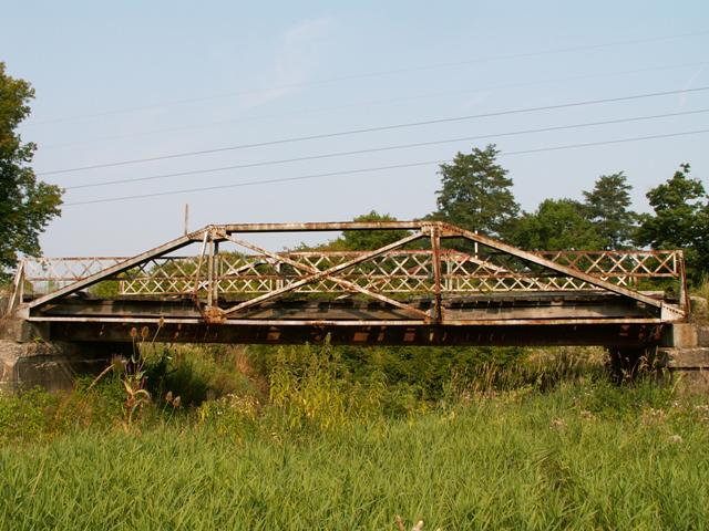
It remains unclear why Queenpost truss bridges are often cast aside as "Pratt" truss bridges, as was done with this bridge in the Historic Bridge Inventory. Queenpost truss bridges should not be considered Pratt truss bridges. Queenpost truss bridges represent a design that was used, particularly in the earlier truss bridge era, to create small spans during a time that steel stringers bridges were not economical due to the limits in size of rolled beams. Although a bridge like this one is a late example, it still represents this truss configuration that was a solution for crossings where a three panel bridge was effective. Truss bridges of this length would not be built often into the 20th Century as steel stringer became common for short span applications.
This bridge was however seriously altered when stringers were added below the trusses. This alteration sets this structure behind other Queenpost bridges found elsewhere, but it remains regionally significant where few other Queenposts are to be found.
Information and Findings From Pennsylvania's Historic Bridge InventoryDiscussion of Bridge The ca. 1910, riveted, Pratt pony truss bridge with outriggers was altered in 1949 when built up stringers were placed below the existing floorbeams. The stringers carry much of the live load. The trusses have minor welded repairs, and they are a common design that is common throughout southwestern Pennsylvania. The bridge, which has no innovative or distinctive details, is not historically or technologically significant. Discussion of Surrounding Area The bridge carries 1 lane of an unimproved road over a stream in a wooded and mixed use area at the southeast end of Somerset. Bridge Considered Historic By Survey: No |
![]()
![]()
Coordinates (Latitude, Longitude):
Search For Additional Bridge Listings:
Bridgehunter.com: View listed bridges within 0.5 miles (0.8 kilometers) of this bridge.
Bridgehunter.com: View listed bridges within 10 miles (16 kilometers) of this bridge.
Additional Maps:
Google Streetview (If Available)
GeoHack (Additional Links and Coordinates)
Apple Maps (Via DuckDuckGo Search)
Apple Maps (Apple devices only)
Android: Open Location In Your Map or GPS App
Flickr Gallery (Find Nearby Photos)
Wikimedia Commons (Find Nearby Photos)
Directions Via Sygic For Android
Directions Via Sygic For iOS and Android Dolphin Browser
USGS National Map (United States Only)
Historical USGS Topo Maps (United States Only)
Historic Aerials (United States Only)
CalTopo Maps (United States Only)

© Copyright 2003-2026, HistoricBridges.org. All Rights Reserved. Disclaimer: HistoricBridges.org is a volunteer group of private citizens. HistoricBridges.org is NOT a government agency, does not represent or work with any governmental agencies, nor is it in any way associated with any government agency or any non-profit organization. While we strive for accuracy in our factual content, HistoricBridges.org offers no guarantee of accuracy. Information is provided "as is" without warranty of any kind, either expressed or implied. Information could include technical inaccuracies or errors of omission. Opinions and commentary are the opinions of the respective HistoricBridges.org member who made them and do not necessarily represent the views of anyone else, including any outside photographers whose images may appear on the page in which the commentary appears. HistoricBridges.org does not bear any responsibility for any consequences resulting from the use of this or any other HistoricBridges.org information. Owners and users of bridges have the responsibility of correctly following all applicable laws, rules, and regulations, regardless of any HistoricBridges.org information.
![]()