

View Information About HSR Ratings
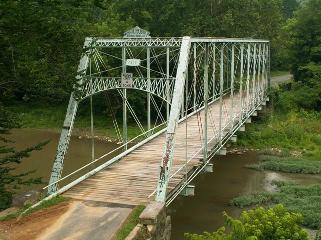
This bridge is an eleven panel pin connected through Whipple truss. This bridge is among the oldest metal truss bridges in Pennsylvania, with an 1878 construction date. The bridge was built by the Massillon Iron Bridge Company. Any metal truss bridge dating from earlier than 1880 is very old, and if it retains even decent integrity is highly significant. This bridge retains a great deal of historic integrity, and further documents a rare example of a Massillon Iron Bridge Company Whipple truss displaying the unique details of that company. The portal bracing of this bridge deserves special note, because it the portal uses a special pole webbing design that was practically Massillon's signature detail during the 1870s. The use of these poles can be seen in the Longman Road Bridge (in the trusses) as well as the Junction Road Bridge (in the top chord), both of Preble County, Ohio. The Pollocks Mill Bridge features large stone abutments, which at one end have extensive wingwalls. The floorbeams and deck were replaced in 1990, suggesting that perhaps someone didn't feel like demolishing it at the time.
This bridge should receive an extremely high priority for preservation, and rehabilitation should be scheduled for this bridge. Rehabilitation should take great care to maintain the excellent historic integrity this bridge enjoys.
The Historic Bridge Inventory's narrative is on-target, and and the historic significance of this bridge is recognized. Also, the survey folks at Lichtenstein apparently have an occasional sense of humor, as indicated in their discussion of the surrounding area!
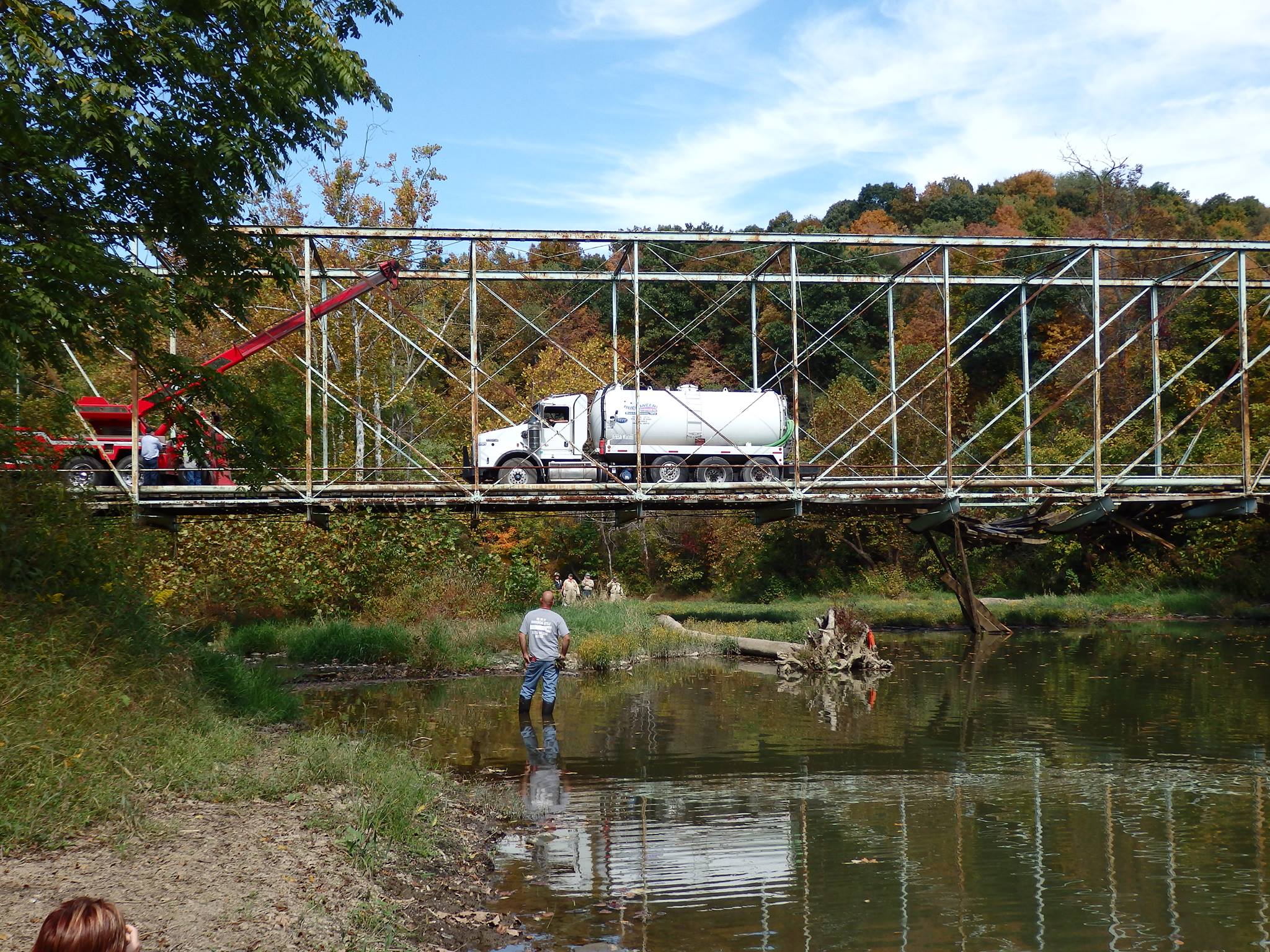
On September 28, 2014, a water tanker truck carrying a full tank of water attempted to cross the bridge which had a posted weight limit of four tons, far less than what this truck was carrying. The result of this is that halfway across the bridge the floorbeams and possibly the truss u-bolt hangers failed causing the deck to drop out and causing the back end of the truck to drop accordingly. The truck driver then dumped his water to reduce his load and abandoned the vehicle, which had to be carefully extricated from the bridge to avoid further damage to the bridge.
There has been some speculation that this truck was hauling water that was related to hydraulic fracturing. If so, this incident is only the latest example of how Pennsylvania is being abused and destroyed by the companies involved in these activities. Bridges are bring damaged and worn out, and the destruction that hydraulic fracturing is causing as it transforms what was once a pristine natural landscape into an industrial wasteland is unimaginable, and ranges from visual destruction to contamination of the water supply (actually it turns drinking water into a flammable substance...).
There has been some discussion about whether the weight limit signs were present at the bridge when this incident occurred. Reviewing the HistoricBridges.org photos, the weight limit sign used to be mounted on the portal bracing, but photos when the accident took place showed that those were replaced with clearance signs. Other more recent photos before the incident showed a weight limit sign posted alongside the road in front of the bridge, but this sign appeared to be missing in photos from the day of the accident. The investigation into this incident should reveal whether there were proper weight limit signs in place. Bridge inspection reports often record this information. In either case, a responsible driver of a truck should have on file a copy of all bridges with restricted weight limits (this can be provided by the county and is on the Internet in the case of Greene County), and the route a truck takes should be pre-planned taking these restrictions into account and the driver should not relying on last-minute routing by a GPS unit. There is no excuse for this incident and the driver and/or trucking company should be held responsible and costs to restore the damage done to this bridge should be sought.
Truck drivers should be the best drivers on the road, because they are in charge of the most dangerous vehicles on the road, since trucks are wider, heavier, slower to stop, and may be carrying hazardous cargo. As such, it is reasonable that they should be required to go the extra step for safety. This is why truck drivers need a special CDL type drivers license. Among their responsibilities is to know what the height of their vehicle is, what the weight of the vehicle is, and where any restricted roads and bridges are located. The smart truck driver should ensure that this information is known before embarking on a route. The information for planning a trip ahead of time to avoid restricted roads and bridges is available freely to truck drivers and indeed the public in general. As such, this incident is reflective of a truck driver who did not take safety seriously. By driving onto this bridge the driver put his own safety and the safety of other drivers at severe risk. Additionally, the driver has caused severe damage to one of the most important historic bridges in southwestern Pennsylvania. This is inexcusable.
This is an exceedingly significant and beautiful historic bridge and it should be restored at all costs. In reality, the work needed to simply repair the damage done by the truck may be minimal. It doesn't always work like this, but often on pin-connected truss bridges (and in the case of this bridge) an overweight load causes failure of the floorbeams and more importantly the u-bolt hangers. These items being the weakest link, they tend to separate from the trusses themselves rather than pulling the trusses down with them.
Evan Williams and the SWPA Rural Exploration Facebook Page were very helpful in providing photos of the incident and some of them are included below. Click them for enlargements.


Above: Views before the truck was extricated.
Above: Truck extrication.
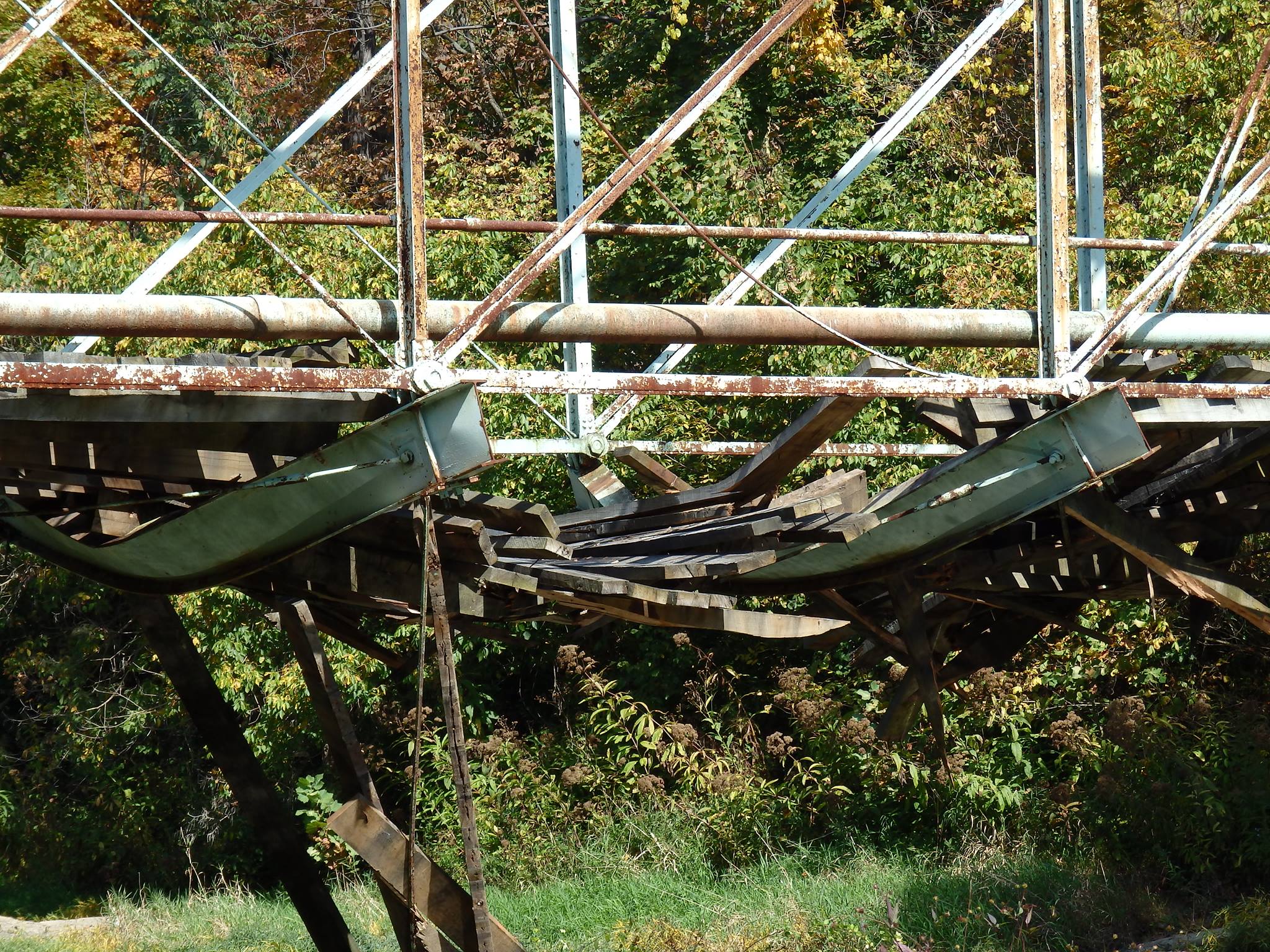
Above: Bridge after truck extrication.
Following this accident, the bridge was repaired, with funding from the insurance carried by the truck. The bridge is again open to traffic as a result.
Information and Findings From Pennsylvania's Historic Bridge InventoryDiscussion of Bridge The 163' long, pin-connected Double Intersection Pratt (Whipple) truss built in 1878 is supported on ashlar abutments with stepped wingwalls. The trusses exhibit many early details including rolled I sections with cover plates riveted to the flanges and cast chafing guards/guides for the diagonals. The counters pass through openings in the web of the verticals. Pin plates riveted to the ends of the verticals facilitate connections at the panel points. In 1990 the original floorbeams were replaced with new steel I beams, and the timber stringers were replaced in kind, otherwise the bridge is remarkably complete. This early bridge is historically and technologically significant. Discussion of Surrounding Area The bridge carries 1 lane of an unimproved township road over a stream in a sparsely developed, forested area. Just east of the bridge is an overpass carrying a branch of the Monongahela RR over TR 597. No buildings are near the bridge, just a dead, mutilated deer carcass,-- charming. Bridge Considered Historic By Survey: Yes |
![]()
![]()
![]()

![]()
Coordinates (Latitude, Longitude):
Search For Additional Bridge Listings:
Bridgehunter.com: View listed bridges within 0.5 miles (0.8 kilometers) of this bridge.
Bridgehunter.com: View listed bridges within 10 miles (16 kilometers) of this bridge.
Additional Maps:
Google Streetview (If Available)
GeoHack (Additional Links and Coordinates)
Apple Maps (Via DuckDuckGo Search)
Apple Maps (Apple devices only)
Android: Open Location In Your Map or GPS App
Flickr Gallery (Find Nearby Photos)
Wikimedia Commons (Find Nearby Photos)
Directions Via Sygic For Android
Directions Via Sygic For iOS and Android Dolphin Browser
USGS National Map (United States Only)
Historical USGS Topo Maps (United States Only)
Historic Aerials (United States Only)
CalTopo Maps (United States Only)

© Copyright 2003-2026, HistoricBridges.org. All Rights Reserved. Disclaimer: HistoricBridges.org is a volunteer group of private citizens. HistoricBridges.org is NOT a government agency, does not represent or work with any governmental agencies, nor is it in any way associated with any government agency or any non-profit organization. While we strive for accuracy in our factual content, HistoricBridges.org offers no guarantee of accuracy. Information is provided "as is" without warranty of any kind, either expressed or implied. Information could include technical inaccuracies or errors of omission. Opinions and commentary are the opinions of the respective HistoricBridges.org member who made them and do not necessarily represent the views of anyone else, including any outside photographers whose images may appear on the page in which the commentary appears. HistoricBridges.org does not bear any responsibility for any consequences resulting from the use of this or any other HistoricBridges.org information. Owners and users of bridges have the responsibility of correctly following all applicable laws, rules, and regulations, regardless of any HistoricBridges.org information.
![]()