

View Information About HSR Ratings

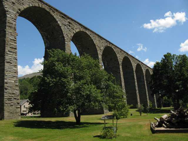
This magnificent structure stands today, not only as one of the oldest and largest railroad bridges in Pennsylvania, but as one of the most impressive and noteworthy examples of a stone bridge in the United States. The bridge soars 100 feet over the valley it crosses, with semicircular stone arch spans supported by stone piers. This bridge was among the last of its kind to be built in the United States, for soon after, metal would become the preferred material for structures of this size. A mighty structure, the bridge today retains excellent historic integrity and is largely unaltered, yet is capable of carrying four times the weight of any train that would have existed in 1848. This bridge is very impressive in appearance and has been compared to Roman aqueducts in terms of visual appearance. The bridge has received designation as a National Historic Civil Engineering Landmark, a designation that very few bridges receive.
Aside from its size and age, the Starrucca Viaduct is noteworthy for its unique design and construction. Review the Historic American Engineering Record drawings for a description of these unusual and noteworthy details. Among the details, the interior of the arch has voids designed to reduce the dead load on the arch. Also, concrete was used in the pier foundations, which would have been an experimental endeavor at the time. Also, the bridge has a 1 degree incline, but was carefully designed to give the illusion of a horizontal bridge.
![]()
![]()
![]()
Coordinates (Latitude, Longitude):
Search For Additional Bridge Listings:
Bridgehunter.com: View listed bridges within 0.5 miles (0.8 kilometers) of this bridge.
Bridgehunter.com: View listed bridges within 10 miles (16 kilometers) of this bridge.
Additional Maps:
Google Streetview (If Available)
GeoHack (Additional Links and Coordinates)
Apple Maps (Via DuckDuckGo Search)
Apple Maps (Apple devices only)
Android: Open Location In Your Map or GPS App
Flickr Gallery (Find Nearby Photos)
Wikimedia Commons (Find Nearby Photos)
Directions Via Sygic For Android
Directions Via Sygic For iOS and Android Dolphin Browser
USGS National Map (United States Only)
Historical USGS Topo Maps (United States Only)
Historic Aerials (United States Only)
CalTopo Maps (United States Only)

© Copyright 2003-2026, HistoricBridges.org. All Rights Reserved. Disclaimer: HistoricBridges.org is a volunteer group of private citizens. HistoricBridges.org is NOT a government agency, does not represent or work with any governmental agencies, nor is it in any way associated with any government agency or any non-profit organization. While we strive for accuracy in our factual content, HistoricBridges.org offers no guarantee of accuracy. Information is provided "as is" without warranty of any kind, either expressed or implied. Information could include technical inaccuracies or errors of omission. Opinions and commentary are the opinions of the respective HistoricBridges.org member who made them and do not necessarily represent the views of anyone else, including any outside photographers whose images may appear on the page in which the commentary appears. HistoricBridges.org does not bear any responsibility for any consequences resulting from the use of this or any other HistoricBridges.org information. Owners and users of bridges have the responsibility of correctly following all applicable laws, rules, and regulations, regardless of any HistoricBridges.org information.
![]()