

View Information About HSR Ratings
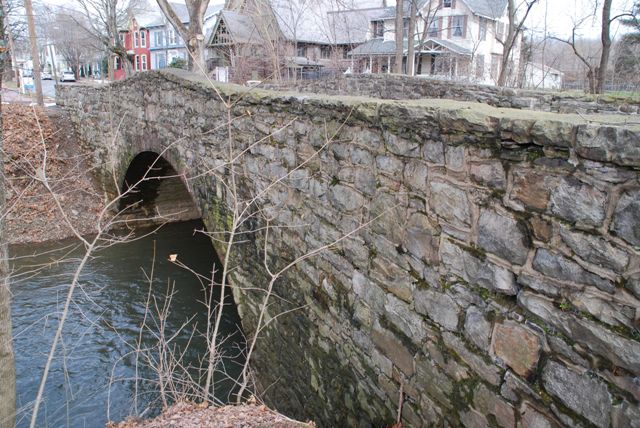
This bridge is a traditional stone arch bridge. It retains excellent historic integrity with no noteworthy alterations visible. It contributes to the Newport Historic District along with the two other stone arch bridges in Newport. The National Bridge Inventory claims the bridge was built in 1920, while the Historic Bridge Inventory claims the bridge is ca. 1895. The Newport Historic District Nomination claims the bridge is ca. 1900. The reality appears to be that nobody really knows when the bridge was built!
Information and Findings From Pennsylvania's Historic Bridge InventoryDiscussion of Bridge The 1-span, 40'-long stone arch bridge with dressed red sandstone voussoirs is supported on stone abutments. It has semi-coursed rubble masonry spandrel walls and parapets with an arched profile. The date of construction and builder of the bridge are undocumented by available records. The bridge dates by style to ca. 1895. The bridge is historically significant as a contributing resource to the potential Newport historic district. The NR-nomination specifically mentions the bridge as a contributing resource. The bridge dates from the district's period of significance and is associated historically with the significant themes of transportation and commerce. Discussion of Surrounding Area The bridge carries a 2 lane street over a stream on the south side of Newport Borough. Newport is a NR-listed historic district (3/12/99), noteworthy for its historic role as a local milling and shipping center. The district includes residential, commercial, and industrial buildings dating from ca. 1840 to 1920. The district boundary is the south bank of the creek and entirely includes the bridge. The late-20th-century garage at the bridge's southwest quadrant is excluded from the district boundary (see map attached to nomination). Bridge Considered Historic By Survey: Yes |
![]()
![]()
![]()
Coordinates (Latitude, Longitude):
Search For Additional Bridge Listings:
Bridgehunter.com: View listed bridges within 0.5 miles (0.8 kilometers) of this bridge.
Bridgehunter.com: View listed bridges within 10 miles (16 kilometers) of this bridge.
Additional Maps:
Google Streetview (If Available)
GeoHack (Additional Links and Coordinates)
Apple Maps (Via DuckDuckGo Search)
Apple Maps (Apple devices only)
Android: Open Location In Your Map or GPS App
Flickr Gallery (Find Nearby Photos)
Wikimedia Commons (Find Nearby Photos)
Directions Via Sygic For Android
Directions Via Sygic For iOS and Android Dolphin Browser
USGS National Map (United States Only)
Historical USGS Topo Maps (United States Only)
Historic Aerials (United States Only)
CalTopo Maps (United States Only)

© Copyright 2003-2024, HistoricBridges.org. All Rights Reserved. Disclaimer: HistoricBridges.org is a volunteer group of private citizens. HistoricBridges.org is NOT a government agency, does not represent or work with any governmental agencies, nor is it in any way associated with any government agency or any non-profit organization. While we strive for accuracy in our factual content, HistoricBridges.org offers no guarantee of accuracy. Information is provided "as is" without warranty of any kind, either expressed or implied. Information could include technical inaccuracies or errors of omission. Opinions and commentary are the opinions of the respective HistoricBridges.org member who made them and do not necessarily represent the views of anyone else, including any outside photographers whose images may appear on the page in which the commentary appears. HistoricBridges.org does not bear any responsibility for any consequences resulting from the use of this or any other HistoricBridges.org information. Owners and users of bridges have the responsibility of correctly following all applicable laws, rules, and regulations, regardless of any HistoricBridges.org information.
![]()