

View Information About HSR Ratings
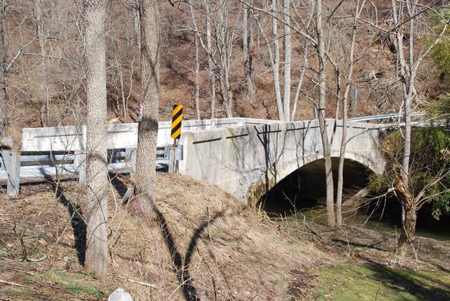
This small concrete arch bridge appears to have been built to a county design.
Information and Findings From Pennsylvania's Historic Bridge InventoryDiscussion of Bridge The single span, 51'-long, reinforced concrete deck arch bridge built in 1914 is finished with spandrel walls and parapets with oversized panels. The reinforced concrete arch bridge technology was introduced in Pennsylvania during the first decade of the 20th century and after 1910 it was ubiquitous. Over 200 pre-1916 examples have been identified with more than 55 from before 1910. This example is one of at least 10 similar bridges in York County from 1910 to 1920. It is not individually distinguished, however, it is located in and dates from the period of significance of a potential rural historic district along the Little Muddy Creek valley. It is contributing. Discussion of Surrounding Area The 1 lane bridge carries a 2 lane road over a stream in a pristine rural area of active farms. At the southeast quadrant is a ca. 1800 banked stone farmhouse. The other quadrants are wooded. A reconnaissance level survey of the area along Little Muddy Creek valley in the vicinity of the bridge indicates that it has the significance and integrity of a potential rural historic district with traditional agricultural settlement patterns, farmsteads, and a mill (Grove Mill). The area is characterized by predominantly 19th to early 20th century buildings with integrity. Bridge Considered Historic By Survey: Yes |
![]()
![]()
![]()
Coordinates (Latitude, Longitude):
Search For Additional Bridge Listings:
Bridgehunter.com: View listed bridges within 0.5 miles (0.8 kilometers) of this bridge.
Bridgehunter.com: View listed bridges within 10 miles (16 kilometers) of this bridge.
Additional Maps:
Google Streetview (If Available)
GeoHack (Additional Links and Coordinates)
Apple Maps (Via DuckDuckGo Search)
Apple Maps (Apple devices only)
Android: Open Location In Your Map or GPS App
Flickr Gallery (Find Nearby Photos)
Wikimedia Commons (Find Nearby Photos)
Directions Via Sygic For Android
Directions Via Sygic For iOS and Android Dolphin Browser
USGS National Map (United States Only)
Historical USGS Topo Maps (United States Only)
Historic Aerials (United States Only)
CalTopo Maps (United States Only)

© Copyright 2003-2024, HistoricBridges.org. All Rights Reserved. Disclaimer: HistoricBridges.org is a volunteer group of private citizens. HistoricBridges.org is NOT a government agency, does not represent or work with any governmental agencies, nor is it in any way associated with any government agency or any non-profit organization. While we strive for accuracy in our factual content, HistoricBridges.org offers no guarantee of accuracy. Information is provided "as is" without warranty of any kind, either expressed or implied. Information could include technical inaccuracies or errors of omission. Opinions and commentary are the opinions of the respective HistoricBridges.org member who made them and do not necessarily represent the views of anyone else, including any outside photographers whose images may appear on the page in which the commentary appears. HistoricBridges.org does not bear any responsibility for any consequences resulting from the use of this or any other HistoricBridges.org information. Owners and users of bridges have the responsibility of correctly following all applicable laws, rules, and regulations, regardless of any HistoricBridges.org information.
![]()