

View Information About HSR Ratings
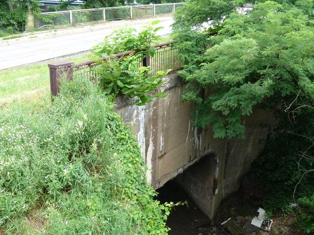
This is a tiny concrete rigid-frame bridge with decorative railing. The railing has been removed on one side since these photos were taken based on Google Street View.
Information and Findings From Pennsylvania's Historic Bridge InventoryDiscussion of Bridge The 1935, 35'-long, reinforced concrete rigid frame bridge is finished with plain spandrel walls and steel railings with cast end posts. The bridge is complete, but it has no innovative or distinctive details. It is one of 35 rigid frame bridges in Allegheny County built between 1929 and 1952. Many of the population date to the early 1930s. Neither the bridge nor its setting are historically or technologically significant. It was not built as an original element of the the 1927 McKeesport-Duquesne Bridge (02 2114 0020 0000). Discussion of Surrounding Area The bridge carries a lane of one-directional traffic, a sidewalk, and grass strip over the access road to the former B & O and P & LE railroad rights of way on the east side of the Monongahela River at the SE end of the 1927 McKeesport-Duquesne Bridge (02 2114 0020 0000). The ramp carries traffic from the bridge to SR 148 South. The McKeesport approach to the bridge is dominated by modern garages and repair facilities. The setting does not have historic district potential. The railroad tracks are north and west of the bridge. Bridge Considered Historic By Survey: No |
This bridge is tagged with the following special condition(s): Unorganized Photos
![]()
![]()
![]()
Coordinates (Latitude, Longitude):
Search For Additional Bridge Listings:
Bridgehunter.com: View listed bridges within 0.5 miles (0.8 kilometers) of this bridge.
Bridgehunter.com: View listed bridges within 10 miles (16 kilometers) of this bridge.
Additional Maps:
Google Streetview (If Available)
GeoHack (Additional Links and Coordinates)
Apple Maps (Via DuckDuckGo Search)
Apple Maps (Apple devices only)
Android: Open Location In Your Map or GPS App
Flickr Gallery (Find Nearby Photos)
Wikimedia Commons (Find Nearby Photos)
Directions Via Sygic For Android
Directions Via Sygic For iOS and Android Dolphin Browser
USGS National Map (United States Only)
Historical USGS Topo Maps (United States Only)
Historic Aerials (United States Only)
CalTopo Maps (United States Only)

© Copyright 2003-2024, HistoricBridges.org. All Rights Reserved. Disclaimer: HistoricBridges.org is a volunteer group of private citizens. HistoricBridges.org is NOT a government agency, does not represent or work with any governmental agencies, nor is it in any way associated with any government agency or any non-profit organization. While we strive for accuracy in our factual content, HistoricBridges.org offers no guarantee of accuracy. Information is provided "as is" without warranty of any kind, either expressed or implied. Information could include technical inaccuracies or errors of omission. Opinions and commentary are the opinions of the respective HistoricBridges.org member who made them and do not necessarily represent the views of anyone else, including any outside photographers whose images may appear on the page in which the commentary appears. HistoricBridges.org does not bear any responsibility for any consequences resulting from the use of this or any other HistoricBridges.org information. Owners and users of bridges have the responsibility of correctly following all applicable laws, rules, and regulations, regardless of any HistoricBridges.org information.
![]()