

View Information About HSR Ratings
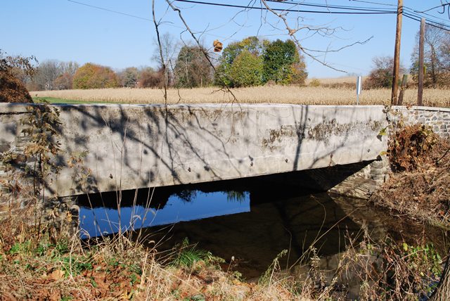
This bridge is a steel stringer bridge with its beams encased in concrete. The bridge is unornamented with solid concrete railings with no decorative details aside from a marble plaque. Like many concrete/steeel bridges in the county however, handsome stone abutments are present.
Information and Findings From Pennsylvania's Historic Bridge InventoryDiscussion of Bridge The one-span, 33'-long bridge is composed of concrete-encased rolled steel beam stringers with the bottom flanges exposed. It has plain concrete parapets and is supported on stone abutments. Fieldstone wingwalls with parapets enclose the approach roadways. Concrete encasement was favored in the state because it provided protection for the steel and eliminated the need to periodically paint the beams. A representative example of one of the most common, 20th century bridge types and designs in the state, it has no innovative or technologically noteworthy details. It is not significant for its setting or context. It is one of over 740 surviving pre-1957 examples, with the oldest dating to about 1900, and more than 35 to before 1911. A more distinguished example in the Chester County context is BMS#15 3016 0030 2812, the earliest identified example in the county and listed as a contributing resource to the Hopewell HD. Discussion of Surrounding Area The bridge carries a 2 lane road over a stream in a rural area of active farms and scattered late-20th-century residential subdivisions. At the bridge's southwest quadrant is a new house, and to the southeast quadrant is a trailer home. Open fields are to the north. The setting does not have historic district potential. Bridge Considered Historic By Survey: Yes |
![]()
![]()
![]()
Coordinates (Latitude, Longitude):
Search For Additional Bridge Listings:
Bridgehunter.com: View listed bridges within 0.5 miles (0.8 kilometers) of this bridge.
Bridgehunter.com: View listed bridges within 10 miles (16 kilometers) of this bridge.
Additional Maps:
Google Streetview (If Available)
GeoHack (Additional Links and Coordinates)
Apple Maps (Via DuckDuckGo Search)
Apple Maps (Apple devices only)
Android: Open Location In Your Map or GPS App
Flickr Gallery (Find Nearby Photos)
Wikimedia Commons (Find Nearby Photos)
Directions Via Sygic For Android
Directions Via Sygic For iOS and Android Dolphin Browser
USGS National Map (United States Only)
Historical USGS Topo Maps (United States Only)
Historic Aerials (United States Only)
CalTopo Maps (United States Only)

© Copyright 2003-2024, HistoricBridges.org. All Rights Reserved. Disclaimer: HistoricBridges.org is a volunteer group of private citizens. HistoricBridges.org is NOT a government agency, does not represent or work with any governmental agencies, nor is it in any way associated with any government agency or any non-profit organization. While we strive for accuracy in our factual content, HistoricBridges.org offers no guarantee of accuracy. Information is provided "as is" without warranty of any kind, either expressed or implied. Information could include technical inaccuracies or errors of omission. Opinions and commentary are the opinions of the respective HistoricBridges.org member who made them and do not necessarily represent the views of anyone else, including any outside photographers whose images may appear on the page in which the commentary appears. HistoricBridges.org does not bear any responsibility for any consequences resulting from the use of this or any other HistoricBridges.org information. Owners and users of bridges have the responsibility of correctly following all applicable laws, rules, and regulations, regardless of any HistoricBridges.org information.
![]()