

View Information About HSR Ratings
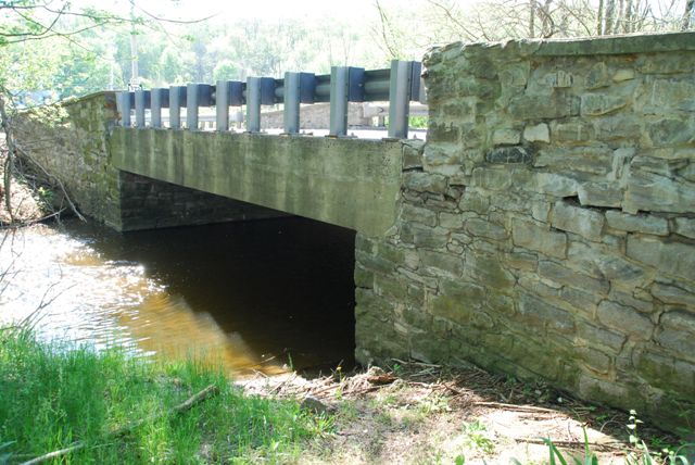
The historic bridge inventory makes note of this bridge as an early example of a number of bridges in Chester County with jack-arch decks. However, the original railings described by the inventory have been replaced with modern guardrail.
Information and Findings From Pennsylvania's Historic Bridge InventoryDiscussion of Bridge The one span, 30'-long steel stringer bridge built in 1914 has a concrete jack arch deck, pipe railings, and stone abutments and wingwalls with parapets. It is among the 21 earliest examples of the steel stringer bridge type and concrete jack arch design identified in the state, and one of the four earliest identified, prototypical examples from 1913-14 in Chester County, where it was popular with County Engineer Nathan R. Rambo during the mid 1910s. More examples of the bridge type and design have been identified in Chester County than any other county in the state. It has typical construction details of the early 20th century and reflects national thinking about bridge technology and design applied in the local context. By using a form liner of wood or corrugated sheet metal placed in an arch shape between the stringers, a concrete deck was poured so as to integrate the stringers with the deck. The jack arches create a strong deck and a stiff member with a minimum of reinforcing bars. Discussion of Surrounding Area The bridge carries a 2 lane road over a stream in a rural setting of active farms and scattered 19th to late-20th-century residences. At the bridge's northeast quadrant is a vernacular 2- story frame residence with replacement windows. Fields and woods are at each of the bridge's other quadrants. The bridge is approximately 1/4-mile east of the Stottsville Inn (1858). North of the inn are a tree farm and a late-20th-century mixing plant. The setting does not have the integrity or cohesiveness of a potential historic district. Bridge Considered Historic By Survey: Yes |
![]()
![]()
![]()
Coordinates (Latitude, Longitude):
Search For Additional Bridge Listings:
Bridgehunter.com: View listed bridges within 0.5 miles (0.8 kilometers) of this bridge.
Bridgehunter.com: View listed bridges within 10 miles (16 kilometers) of this bridge.
Additional Maps:
Google Streetview (If Available)
GeoHack (Additional Links and Coordinates)
Apple Maps (Via DuckDuckGo Search)
Apple Maps (Apple devices only)
Android: Open Location In Your Map or GPS App
Flickr Gallery (Find Nearby Photos)
Wikimedia Commons (Find Nearby Photos)
Directions Via Sygic For Android
Directions Via Sygic For iOS and Android Dolphin Browser
USGS National Map (United States Only)
Historical USGS Topo Maps (United States Only)
Historic Aerials (United States Only)
CalTopo Maps (United States Only)

© Copyright 2003-2024, HistoricBridges.org. All Rights Reserved. Disclaimer: HistoricBridges.org is a volunteer group of private citizens. HistoricBridges.org is NOT a government agency, does not represent or work with any governmental agencies, nor is it in any way associated with any government agency or any non-profit organization. While we strive for accuracy in our factual content, HistoricBridges.org offers no guarantee of accuracy. Information is provided "as is" without warranty of any kind, either expressed or implied. Information could include technical inaccuracies or errors of omission. Opinions and commentary are the opinions of the respective HistoricBridges.org member who made them and do not necessarily represent the views of anyone else, including any outside photographers whose images may appear on the page in which the commentary appears. HistoricBridges.org does not bear any responsibility for any consequences resulting from the use of this or any other HistoricBridges.org information. Owners and users of bridges have the responsibility of correctly following all applicable laws, rules, and regulations, regardless of any HistoricBridges.org information.
![]()