

View Information About HSR Ratings
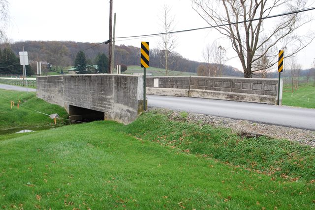
This is a small steel stringer bridge that features concrete encased stringers. Combined with concrete railing, this looks like an all-concrete bridge. The only architectural detailing is the rectangle outlines on the inside of the solid parapets. No detailing is present on the outside of the bridge, indicating that having a nice looking bridge here was only of interest to those driving over the bridge. Given the rural agricultural location of the bridge this is perhaps not suprising.
Information and Findings From Pennsylvania's Historic Bridge InventoryDiscussion of Bridge The single span, 27'-long, encased steel stringer bridge is supported on concrete abutments and has concrete parapets. The beams are encased down to the exposed bottom flanges of the I-shaped beams. Concrete encasement was favored in the state because it provided protection for the steel and eliminated the need to periodically paint the beams. A representative example of one of the most common, early-to-mid-20th century bridge types and designs in the state, it has no innovative or distinguishing details. It is one of 639 Discussion of Surrounding Area The bridge carries a 2 lane road over a stream in a rural area of active farms and scattered late-20th century residences. The setting does not appear to have historic district potential. Bridge Considered Historic By Survey: No |
![]()
![]()
![]()
Coordinates (Latitude, Longitude):
Search For Additional Bridge Listings:
Bridgehunter.com: View listed bridges within 0.5 miles (0.8 kilometers) of this bridge.
Bridgehunter.com: View listed bridges within 10 miles (16 kilometers) of this bridge.
Additional Maps:
Google Streetview (If Available)
GeoHack (Additional Links and Coordinates)
Apple Maps (Via DuckDuckGo Search)
Apple Maps (Apple devices only)
Android: Open Location In Your Map or GPS App
Flickr Gallery (Find Nearby Photos)
Wikimedia Commons (Find Nearby Photos)
Directions Via Sygic For Android
Directions Via Sygic For iOS and Android Dolphin Browser
USGS National Map (United States Only)
Historical USGS Topo Maps (United States Only)
Historic Aerials (United States Only)
CalTopo Maps (United States Only)

© Copyright 2003-2024, HistoricBridges.org. All Rights Reserved. Disclaimer: HistoricBridges.org is a volunteer group of private citizens. HistoricBridges.org is NOT a government agency, does not represent or work with any governmental agencies, nor is it in any way associated with any government agency or any non-profit organization. While we strive for accuracy in our factual content, HistoricBridges.org offers no guarantee of accuracy. Information is provided "as is" without warranty of any kind, either expressed or implied. Information could include technical inaccuracies or errors of omission. Opinions and commentary are the opinions of the respective HistoricBridges.org member who made them and do not necessarily represent the views of anyone else, including any outside photographers whose images may appear on the page in which the commentary appears. HistoricBridges.org does not bear any responsibility for any consequences resulting from the use of this or any other HistoricBridges.org information. Owners and users of bridges have the responsibility of correctly following all applicable laws, rules, and regulations, regardless of any HistoricBridges.org information.
![]()