

View Information About HSR Ratings
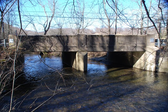
This bridge is an unaltered example of a county designed concrete slab bridge. It has paneled railings and includes a bronze plaque. The bridge was found to be non-contributing structure of a Historic District because it was built after the period of significance. This may be the case, but its also worth noting that a nice looking 1920s bridge still will blend in with a Historic District a lot better than a modern replacement bridge would. Thus, even non-contributing bridges that are older and nicer looking than modern bridges should still be considered for preservation simply because they harmonize with the Historic District better even if they don't officially contribute.
Information and Findings From Pennsylvania's Historic Bridge InventoryDiscussion of Bridge The 2 span, reinforced concrete slab bridge built in 1923 has paneled parapets and is supported on a concrete substructure. It is an example of a very common bridge type that was used with great frequency from the late 1910s through the 1950s. It is one of over 750 Discussion of Surrounding Area The bridge carries a 2 lane road over a stream in an 18th and 19th century rural setting. The bridge is in the National Register listed Paradise Valley Historic District (12/24/92). The district's period of significance is from 1700 to 1899. Early-20th century residences are rated noncontributing. Bridge Considered Historic By Survey: No |
![]()
![]()
![]()
Coordinates (Latitude, Longitude):
Search For Additional Bridge Listings:
Bridgehunter.com: View listed bridges within 0.5 miles (0.8 kilometers) of this bridge.
Bridgehunter.com: View listed bridges within 10 miles (16 kilometers) of this bridge.
Additional Maps:
Google Streetview (If Available)
GeoHack (Additional Links and Coordinates)
Apple Maps (Via DuckDuckGo Search)
Apple Maps (Apple devices only)
Android: Open Location In Your Map or GPS App
Flickr Gallery (Find Nearby Photos)
Wikimedia Commons (Find Nearby Photos)
Directions Via Sygic For Android
Directions Via Sygic For iOS and Android Dolphin Browser
USGS National Map (United States Only)
Historical USGS Topo Maps (United States Only)
Historic Aerials (United States Only)
CalTopo Maps (United States Only)

© Copyright 2003-2024, HistoricBridges.org. All Rights Reserved. Disclaimer: HistoricBridges.org is a volunteer group of private citizens. HistoricBridges.org is NOT a government agency, does not represent or work with any governmental agencies, nor is it in any way associated with any government agency or any non-profit organization. While we strive for accuracy in our factual content, HistoricBridges.org offers no guarantee of accuracy. Information is provided "as is" without warranty of any kind, either expressed or implied. Information could include technical inaccuracies or errors of omission. Opinions and commentary are the opinions of the respective HistoricBridges.org member who made them and do not necessarily represent the views of anyone else, including any outside photographers whose images may appear on the page in which the commentary appears. HistoricBridges.org does not bear any responsibility for any consequences resulting from the use of this or any other HistoricBridges.org information. Owners and users of bridges have the responsibility of correctly following all applicable laws, rules, and regulations, regardless of any HistoricBridges.org information.
![]()