

View Information About HSR Ratings
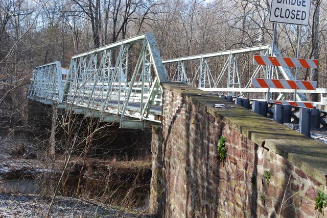
This bridge stands out as an uncommon example of a multi-span pin-connected pony truss. The endposts have welded alterations, and the outriggers are not original to the bridge.
Information and Findings From Pennsylvania's Historic Bridge InventoryDiscussion of Bridge The 2-span, 158' long pin connected Pratt pony truss bridge is supported on a stone substructure. The trusses are traditionally composed with built up box section upper chords and inclined end posts. The verticals are angles with lacing on the upper portions and stay plates on the lower part. The diagonals and lower chords are eye bars. The trusses have been altered. Cover plates have been welded to the end posts and upper chords, and outriggers have added as have welded substruts in the outside panels. The plaque dates the substructure to 1892, and it is assumed that the pin connected truss bridge is contemporary with the substructure. Another plaque states that the bridge was rehabilitated in 1987 by the county. The altered bridge has no innovative or distinctive details, and it represents the standardization of the type and design that is typical of the 1890s. It is not historically and technologically significant. Discussion of Surrounding Area The bridge carries a 2 lane road over a stream in a sparsely developed, forested setting. Bridge Considered Historic By Survey: No |
![]()
![]()
![]()
This historic bridge has been demolished. This map is shown for reference purposes only.
Coordinates (Latitude, Longitude):
Search For Additional Bridge Listings:
Bridgehunter.com: View listed bridges within 0.5 miles (0.8 kilometers) of this bridge.
Bridgehunter.com: View listed bridges within 10 miles (16 kilometers) of this bridge.
Additional Maps:
Google Streetview (If Available)
GeoHack (Additional Links and Coordinates)
Apple Maps (Via DuckDuckGo Search)
Apple Maps (Apple devices only)
Android: Open Location In Your Map or GPS App
Flickr Gallery (Find Nearby Photos)
Wikimedia Commons (Find Nearby Photos)
Directions Via Sygic For Android
Directions Via Sygic For iOS and Android Dolphin Browser
USGS National Map (United States Only)
Historical USGS Topo Maps (United States Only)
Historic Aerials (United States Only)
CalTopo Maps (United States Only)

© Copyright 2003-2024, HistoricBridges.org. All Rights Reserved. Disclaimer: HistoricBridges.org is a volunteer group of private citizens. HistoricBridges.org is NOT a government agency, does not represent or work with any governmental agencies, nor is it in any way associated with any government agency or any non-profit organization. While we strive for accuracy in our factual content, HistoricBridges.org offers no guarantee of accuracy. Information is provided "as is" without warranty of any kind, either expressed or implied. Information could include technical inaccuracies or errors of omission. Opinions and commentary are the opinions of the respective HistoricBridges.org member who made them and do not necessarily represent the views of anyone else, including any outside photographers whose images may appear on the page in which the commentary appears. HistoricBridges.org does not bear any responsibility for any consequences resulting from the use of this or any other HistoricBridges.org information. Owners and users of bridges have the responsibility of correctly following all applicable laws, rules, and regulations, regardless of any HistoricBridges.org information.
![]()