

View Information About HSR Ratings
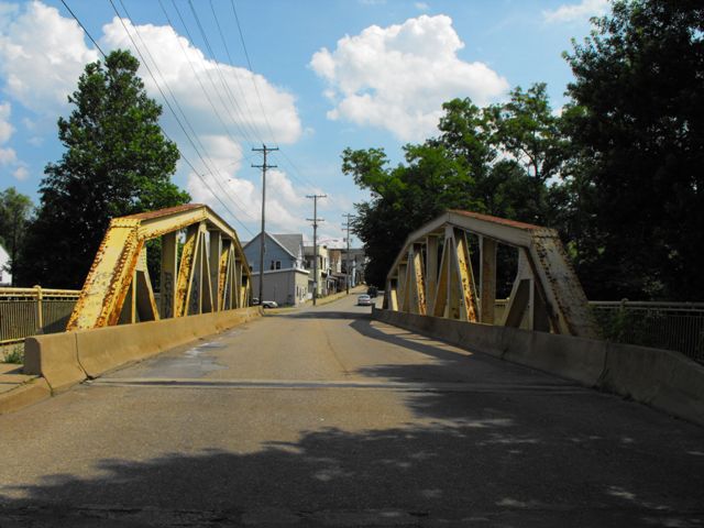
According to Bridgemapper, this bridge is the longest Warren pony truss in the state. As a result, this bridge gains additional historic significance beyond what it already claims as a good representative example of a 1920s pony truss with good historic integrity. Some of the reason this bridge bears the distinction of its length is because most other truss bridges from the early 20th century were designed by the state and follow a Parker configuration, so the number of Warrens or polygonal Warrens is relatively low. This bridge is a county-designed bridge. Note that most pre-standard pony truss bridges rarely exceeded 100 feet, it was only in the later truss bridge era that a 140 foot pony truss might have been built.
This bridge is a county-designed standard plan truss bridge. The Pennsylvania Historic Bridge Inventory dismissed nearly all state standard (and county standard) plan truss bridges as not historic and not eligible for the National Register of Historic Places, regardless of integrity, size, or construction date. Given the rate of demolition and reduction of surviving examples of this bridge type, HistoricBridges.org strongly disagrees with this finding. It is outdated and further disproved by the fact that other states and other historic resource consultants found state standard truss bridges eligible in other states. The Pennsylvania historic bridge inventory operates on the philosophy that historic significant arises only from innovative, prototypical engineering, and that significance does not arise from good representative examples of structures from a period in history. This appears to go against the philosophy of the National Register of Historic Places which has accepted structures from both categories in other states. The information below from the Historic Bridge Inventory is provided for structure information and reference only. HistoricBridges.org does not agree with the findings of the below historic bridge inventory assessment. It should also be noted that in 2001, the findings of the historic bridge inventory were overturned, as they needed to be.
Information and Findings From Pennsylvania's Historic Bridge InventoryDiscussion of Bridge The 1927, riveted, single span, 7 panel, 146'-long, Warren with verticals pony truss bridge is supported on concrete abutments with flared wingwalls. The trusses have built up box section chords, and the verticals and diagonals are built up from angles and plate. The bridge, constructed by the county during its 1924-1932 road and bridge building program, is an example of a type and design that had been used with great frequency since the early 20th century. It has no innovative or distinctive details. Neither the bridge nor its setting is historically or technologically significant. Discussion of Surrounding Area The bridge carries a 2 lane street and 2 sidewalks over a stream in a mixed use section of Carnegie Borough. To the north are undistinguished, late 19th and early 20th century brick houses, many converted to business uses, as well as scattered post-WW II commercial buildings. The area south of the bridge is dominated by undistinguished, altered, early 20th century residences, many with altered facades and replacement windows. There is also a parking lot at the southeast quadrant. The area lacks the architectural significance and cohesiveness of a potential historic district. Bridge Considered Historic By Survey: Yes, After 2001 |
![]()
![]()
![]()
Coordinates (Latitude, Longitude):
Search For Additional Bridge Listings:
Bridgehunter.com: View listed bridges within 0.5 miles (0.8 kilometers) of this bridge.
Bridgehunter.com: View listed bridges within 10 miles (16 kilometers) of this bridge.
Additional Maps:
Google Streetview (If Available)
GeoHack (Additional Links and Coordinates)
Apple Maps (Via DuckDuckGo Search)
Apple Maps (Apple devices only)
Android: Open Location In Your Map or GPS App
Flickr Gallery (Find Nearby Photos)
Wikimedia Commons (Find Nearby Photos)
Directions Via Sygic For Android
Directions Via Sygic For iOS and Android Dolphin Browser
USGS National Map (United States Only)
Historical USGS Topo Maps (United States Only)
Historic Aerials (United States Only)
CalTopo Maps (United States Only)

© Copyright 2003-2024, HistoricBridges.org. All Rights Reserved. Disclaimer: HistoricBridges.org is a volunteer group of private citizens. HistoricBridges.org is NOT a government agency, does not represent or work with any governmental agencies, nor is it in any way associated with any government agency or any non-profit organization. While we strive for accuracy in our factual content, HistoricBridges.org offers no guarantee of accuracy. Information is provided "as is" without warranty of any kind, either expressed or implied. Information could include technical inaccuracies or errors of omission. Opinions and commentary are the opinions of the respective HistoricBridges.org member who made them and do not necessarily represent the views of anyone else, including any outside photographers whose images may appear on the page in which the commentary appears. HistoricBridges.org does not bear any responsibility for any consequences resulting from the use of this or any other HistoricBridges.org information. Owners and users of bridges have the responsibility of correctly following all applicable laws, rules, and regulations, regardless of any HistoricBridges.org information.
![]()