

View Information About HSR Ratings
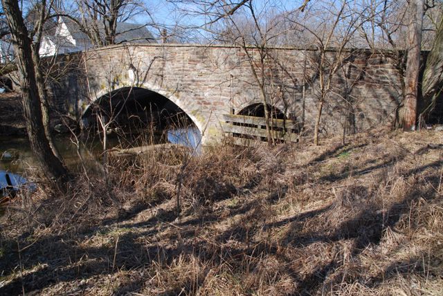
This bridge is traditionally composed, but in addition to its forty foot primary span, there is a much smaller additional span at one end of the bridge. Both spans have been altered with the addition of a corrugated steel liner under the arches.
Information and Findings From Pennsylvania's Historic Bridge InventoryDiscussion of Bridge The two-span, 40'-long stone arch bridge, built in 1912, has voussoirs with keystone, fieldstone spandrel walls, and parapets with sections of replacement concrete coping. It is supported on a stone pier and abutments with wingwalls. The bridge has been heavily repointed. In 1986, the arches were strengthened with steel plate liners. The bridge is an altered example of a bridge type that is common from the first two decades of the 20th century in Chester County. The county-built traditional stone arch bridges were favored by the county engineer, and at least 19 similar bridges from 1908 to 1919 have been identified. Stone arch bridges have been in use in Pennsylvania since the late 17th century, and over 350 examples have been identified statewide, with more than two-thirds dating to before 1900. Early 20th century examples in Chester County are considered individually significant in the local context only when they are complete and large or particularly well detailed. This altered example is not historically or technologically distinguished within its population or by its setting and context. Discussion of Surrounding Area The bridge carries a 2 lane road over a stream in a mixed 19th- to late-20th-century residential area in the town of Avondale. At the bridge's southeast quadrant is a playground and at the northeast quadrant is an empty lot. At the northwest quadrant is an altered one story church building with front and rear additions and loss of fenestration. At the southwest quadrant is an altered late-19th-century vernacular frame residence with replacement siding and fenestration. The immediate setting does not appear to have historic district potential based on the level of irreversible alterations and lack of overall architectural integrity. Bridge Considered Historic By Survey: No Information and Findings From Pennsylvania's Stone Arch Bridge Management PlanDiscussion of Bridge The bridge is recommended for the Reserve Pool. The bridge's condition code is very high; no specific action is required. Its waterway is adequate. Because most of the bridge is intact, the bridge would be relatively inexpensive to rehabilitate. The bridge is not individually eligible for listing in the National Register of Historic Places, but it contributes to the Avondale Historic District. The bridge has received some public support (two emails), and the community has a strong sense of its history. However, the bridge carries a moderate amount of traffic and its roadway width is narrow. It lies in an area of rapid development, where it will experience an increase in traffic in the future, perhaps beyond what it can adequately handle. For this reason, it is not recommended for long-term preservation at this time. Ratings The Avondale, Third Street Bridge is owned by
PennDOT and is ranked 77th. Recommendation: Recommended for the Reserve Pool. |
![]()
![]()
![]()
Coordinates (Latitude, Longitude):
Search For Additional Bridge Listings:
Bridgehunter.com: View listed bridges within 0.5 miles (0.8 kilometers) of this bridge.
Bridgehunter.com: View listed bridges within 10 miles (16 kilometers) of this bridge.
Additional Maps:
Google Streetview (If Available)
GeoHack (Additional Links and Coordinates)
Apple Maps (Via DuckDuckGo Search)
Apple Maps (Apple devices only)
Android: Open Location In Your Map or GPS App
Flickr Gallery (Find Nearby Photos)
Wikimedia Commons (Find Nearby Photos)
Directions Via Sygic For Android
Directions Via Sygic For iOS and Android Dolphin Browser
USGS National Map (United States Only)
Historical USGS Topo Maps (United States Only)
Historic Aerials (United States Only)
CalTopo Maps (United States Only)

© Copyright 2003-2024, HistoricBridges.org. All Rights Reserved. Disclaimer: HistoricBridges.org is a volunteer group of private citizens. HistoricBridges.org is NOT a government agency, does not represent or work with any governmental agencies, nor is it in any way associated with any government agency or any non-profit organization. While we strive for accuracy in our factual content, HistoricBridges.org offers no guarantee of accuracy. Information is provided "as is" without warranty of any kind, either expressed or implied. Information could include technical inaccuracies or errors of omission. Opinions and commentary are the opinions of the respective HistoricBridges.org member who made them and do not necessarily represent the views of anyone else, including any outside photographers whose images may appear on the page in which the commentary appears. HistoricBridges.org does not bear any responsibility for any consequences resulting from the use of this or any other HistoricBridges.org information. Owners and users of bridges have the responsibility of correctly following all applicable laws, rules, and regulations, regardless of any HistoricBridges.org information.
![]()