

View Information About HSR Ratings
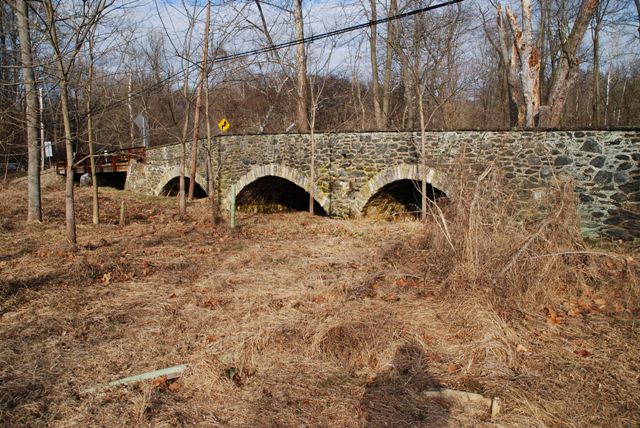
This bridge is one of Chester County's early 20th Century stone arches, built under the direction of county engineer Nathan Rambo. His family had a history of owning limestone quarries which may partly explain why this engineer continued to build stone bridges at a time when metal and concrete had become the most common bridge materials. This bridge is actually composed of the stone arch bridge and also a two span steel stringer bridge that dates to 1937 and is not part of the original bridge. The stringer and stone arch are treated as separate bridges in the National Bridge Inventory. HistoricBridges.org also considers them two bridges because the stringer bridge is not original nor is it historically significant. The measurements given in the technical facts table above refer to the stone arch portion of the bridge only.
Information and Findings From Pennsylvania's Historic Bridge InventoryDiscussion of Bridge The 3 span, 68'-long, stone arch bridge built in 1915 has voussoirs, fieldstone spandrel walls and parapets with sections of replacement concrete coping. The bridge is an example of a bridge type that is common from the first two decades of the 20th century in Chester County. The county-built traditional stone arch bridges were favored by the county engineer, and at least 19 similar bridges from 1908 to 1919 have been identified. Stone arch bridges have been in use in Pennsylvania since the late 17th century, and over 350 examples have been identified statewide, with more than two-thirds dating to before 1900. Early 20th century examples in Chester County are considered individually significant in the local context only when they are complete and large or particularly well detailed. This example is not historically or technologically distinguished within its population or by its setting and context. Discussion of Surrounding Area The bridge carries a 2 lane road over a stream in a rural setting of fields and woods with scattered 19th to late-20th-century residences in the vicinity, but not within view of the bridge. The setting does not have historic district potential. The bridge is in tandem with a steel stringer bridge built in 1937 over the same stream (15304900603247). The steel stringer bridge replaced a covered bridge from 1876. The 1915 stone arch was built as an extension to the covered bridge to cross the floodplain, which is frequently flooded. Bridge Considered Historic By Survey: No Discussion of Attached Stringer Bridge The 2 span, 68'-long, steel stringer bridge built in 1937 has 2-high rail metal railings. It is supported on rubble masonry abutments and pier with concrete caps. In ca. 1980 the timber deck was replaced with an open steel grid deck. It is a standard design developed in the early 1930s by the state highway department as a low cost bridge for rural highways. More than 850 examples from 1930 to 1955 have been identified in the state. More than 40 examples date to before 1935. This later example has no technologically distinguishing details, and it is not historically significant for its setting or context. Discussion of Surrounding Area For Attached Stringer Bridge The bridge carries a 2 lane road over a stream in a rural setting of fields and woods with scattered 19th to late-20th-century residences in the vicinity, but not within view of the bridge. The setting does not have historic district potential. The bridge is in tandem with a 3 span stone arch bridge over the same stream (15304900603161). The steel stringer bridge replaced a covered bridge from 1876. The stone arch to the south was built in 1915 as an extension over the adjacent floodplain, which is frequently flooded. Bridge Considered Historic By Survey: No Information and Findings From Pennsylvania's Stone Arch Bridge Management PlanDiscussion of Bridge This bridge is not recommended for long-term preservation. The bridge has poor integrity. It actually consists of two portions: a stone arch section and a steel stringer section, which replaced a stone section that washed out. Because of the steel stringer portion, it would be a relatively expensive bridge to rehabilitate back to its historic appearance. Its transportation code is moderate, bordering on low, a result of moderate traffic and a narrow roadway width. It lies in an area of low development potential; it may be able to carry its traffic for some time, but any increase would be detrimental. Its condition code and waterway are merely moderate. The bridge has received some public support (two emails), but it is not listed in or eligible for listing in the National Register of Historic Places individually or as part of a historic district, and it is not part of a greenway, natural area, or park. Ratings The Newlin, Brandywine Creek Road Bridge is owned by
PennDOT and is ranked 92nd. Recommendation: Not recommended for long-term preservation. |
![]()
![]()
![]()
Coordinates (Latitude, Longitude):
Search For Additional Bridge Listings:
Bridgehunter.com: View listed bridges within 0.5 miles (0.8 kilometers) of this bridge.
Bridgehunter.com: View listed bridges within 10 miles (16 kilometers) of this bridge.
Additional Maps:
Google Streetview (If Available)
GeoHack (Additional Links and Coordinates)
Apple Maps (Via DuckDuckGo Search)
Apple Maps (Apple devices only)
Android: Open Location In Your Map or GPS App
Flickr Gallery (Find Nearby Photos)
Wikimedia Commons (Find Nearby Photos)
Directions Via Sygic For Android
Directions Via Sygic For iOS and Android Dolphin Browser
USGS National Map (United States Only)
Historical USGS Topo Maps (United States Only)
Historic Aerials (United States Only)
CalTopo Maps (United States Only)

© Copyright 2003-2024, HistoricBridges.org. All Rights Reserved. Disclaimer: HistoricBridges.org is a volunteer group of private citizens. HistoricBridges.org is NOT a government agency, does not represent or work with any governmental agencies, nor is it in any way associated with any government agency or any non-profit organization. While we strive for accuracy in our factual content, HistoricBridges.org offers no guarantee of accuracy. Information is provided "as is" without warranty of any kind, either expressed or implied. Information could include technical inaccuracies or errors of omission. Opinions and commentary are the opinions of the respective HistoricBridges.org member who made them and do not necessarily represent the views of anyone else, including any outside photographers whose images may appear on the page in which the commentary appears. HistoricBridges.org does not bear any responsibility for any consequences resulting from the use of this or any other HistoricBridges.org information. Owners and users of bridges have the responsibility of correctly following all applicable laws, rules, and regulations, regardless of any HistoricBridges.org information.
![]()