

View Information About HSR Ratings
This small truss bridge is a good example of one of the many reasons why truss bridges are important to preserve. Brush Creek is a very small creek that might pass un-noticed to people traveling down the road. But thanks to the trusses of this bridge, people can immediately recognize that they are crossing something. The bridge also simply adds a bit a variety to an otherwise uneventful drive.
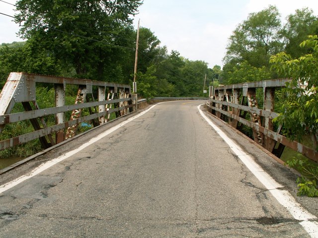
This bridge is unusual because it has large concrete panels on the approach. The bridge is unfortunately not in the best of condition. In particular, the bottom chord appeared to be in very bad shape, with its v-lacing all but rusted away due to extensive section loss.
Today, this attractive historic bridge is nothing more than an organized arrangement of colored pixels that you see on your screen when you look at the photo above.
Information and Findings From Pennsylvania's Historic Bridge InventoryDiscussion of Bridge The single-span, 78'-long and 22' wide, riveted Warren with verticals pony truss bridge was built in 1929 as a replacement for an 1871 bridge. The bridge is supported on concrete abutments with wingwalls, and the trusses are traditionally composed. It has no innovative or distinctive details. It is a late example of a type and design that was common by 1910 throughout the state. Neither the bridge nor its setting is historically or technologically significant. It is one of 18 remaining truss bridges built between 1878 and 1939 in Beaver County. Discussion of Surrounding Area The bridge carries a two-lane road over a stream in a sparsely developed, rural area with scattered 20th century houses and a local greenspace park beyond the northeast quadrant. Bridge Considered Historic By Survey: No |
![]()
![]()
![]()
This historic bridge has been demolished. This map is shown for reference purposes only.
Coordinates (Latitude, Longitude):
Search For Additional Bridge Listings:
Bridgehunter.com: View listed bridges within 0.5 miles (0.8 kilometers) of this bridge.
Bridgehunter.com: View listed bridges within 10 miles (16 kilometers) of this bridge.
Additional Maps:
Google Streetview (If Available)
GeoHack (Additional Links and Coordinates)
Apple Maps (Via DuckDuckGo Search)
Apple Maps (Apple devices only)
Android: Open Location In Your Map or GPS App
Flickr Gallery (Find Nearby Photos)
Wikimedia Commons (Find Nearby Photos)
Directions Via Sygic For Android
Directions Via Sygic For iOS and Android Dolphin Browser
USGS National Map (United States Only)
Historical USGS Topo Maps (United States Only)
Historic Aerials (United States Only)
CalTopo Maps (United States Only)

© Copyright 2003-2024, HistoricBridges.org. All Rights Reserved. Disclaimer: HistoricBridges.org is a volunteer group of private citizens. HistoricBridges.org is NOT a government agency, does not represent or work with any governmental agencies, nor is it in any way associated with any government agency or any non-profit organization. While we strive for accuracy in our factual content, HistoricBridges.org offers no guarantee of accuracy. Information is provided "as is" without warranty of any kind, either expressed or implied. Information could include technical inaccuracies or errors of omission. Opinions and commentary are the opinions of the respective HistoricBridges.org member who made them and do not necessarily represent the views of anyone else, including any outside photographers whose images may appear on the page in which the commentary appears. HistoricBridges.org does not bear any responsibility for any consequences resulting from the use of this or any other HistoricBridges.org information. Owners and users of bridges have the responsibility of correctly following all applicable laws, rules, and regulations, regardless of any HistoricBridges.org information.
![]()