

View Information About HSR Ratings
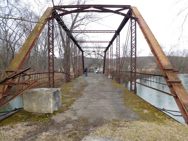
This bridge appears to be the work of the York Bridge Company based on its railing and other truss details. York County appears to have used York Bridge Company railing on other bridges (unclear if it was salvaged railing or bought new from the company). However this appears to be a whole York Bridge Company bridge because the construction date matches the company's years of operation and it has the company's preferred a-frame portal bracing. The bridge is abandoned and the distinctive railing is damaged or missing in many panels.
The Historic Bridge Inventory failed to notice the railing and suggest York Bridge Company as the likely builder of this bridge.
Information and Findings From Pennsylvania's Historic Bridge InventoryDiscussion of Bridge The single-span, 91'-long, pin-connected, steel Pratt thru truss bridge built in 1908 is supported on stone abutments with wingwalls. It is traditionally composed of built-up compression members and eye-bar tension members. Ca. 1970, the bridge deck was replaced with a bituminous-filled steel deck, the lower chords were strengthened by post-tensioning with steel cables, welded repairs were made to the eye bars at the lower panel points, and the floorbeams were picked up by hangers welded to the verticals. The bridge has lost integrity of original design. Pin-connected truss highway bridges from the 1880s to the early 1910s are not uncommon in the northern Pennsylvania region. At least nine examples remain from 1888 to 1908 in McKean County. Earlier and more complete examples represent the significance of the type and design. Discussion of Surrounding Area The bridge is located on a 2 lane road over a stream. It has been closed to traffic. The setting is sparsely developed and forested. It does not have historic district potential. Bridge Considered Historic By Survey: No |
This bridge is tagged with the following special condition(s): Unorganized Photos
![]()
![]()
![]()
Coordinates (Latitude, Longitude):
Search For Additional Bridge Listings:
Bridgehunter.com: View listed bridges within 0.5 miles (0.8 kilometers) of this bridge.
Bridgehunter.com: View listed bridges within 10 miles (16 kilometers) of this bridge.
Additional Maps:
Google Streetview (If Available)
GeoHack (Additional Links and Coordinates)
Apple Maps (Via DuckDuckGo Search)
Apple Maps (Apple devices only)
Android: Open Location In Your Map or GPS App
Flickr Gallery (Find Nearby Photos)
Wikimedia Commons (Find Nearby Photos)
Directions Via Sygic For Android
Directions Via Sygic For iOS and Android Dolphin Browser
USGS National Map (United States Only)
Historical USGS Topo Maps (United States Only)
Historic Aerials (United States Only)
CalTopo Maps (United States Only)

© Copyright 2003-2024, HistoricBridges.org. All Rights Reserved. Disclaimer: HistoricBridges.org is a volunteer group of private citizens. HistoricBridges.org is NOT a government agency, does not represent or work with any governmental agencies, nor is it in any way associated with any government agency or any non-profit organization. While we strive for accuracy in our factual content, HistoricBridges.org offers no guarantee of accuracy. Information is provided "as is" without warranty of any kind, either expressed or implied. Information could include technical inaccuracies or errors of omission. Opinions and commentary are the opinions of the respective HistoricBridges.org member who made them and do not necessarily represent the views of anyone else, including any outside photographers whose images may appear on the page in which the commentary appears. HistoricBridges.org does not bear any responsibility for any consequences resulting from the use of this or any other HistoricBridges.org information. Owners and users of bridges have the responsibility of correctly following all applicable laws, rules, and regulations, regardless of any HistoricBridges.org information.
![]()