

View Information About HSR Ratings
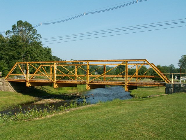
Outside of Cooperstown, the road this bridge is on is known as Woolen Mills Road. The bridge is a five panel half-hip Pratt pony truss, and featured pinned connections. The deck is wooden. There is v-lacing present on the built-up vertical members.
When Daniel Alward of the now-defunct Disappearing Bridges website visited the bridge he found the remains of a plaque that was clearly a Massillon Bridge Company plaque, which allowed the builder of this structure to be identified. The remains of that plaque did not remain in 2006 when HistoricBridges.org documented the bridge. The bridge's highly unusual channel-like railing is original and is a distinctive railing design that was used by Massillon Bridge Company. Even without a plaque, this railing is clear evidence of who built the bridge.
Although originally, the Historic Bridge Inventory did not find this bridge Eligible for Listing in the National Register of Historic Places, and also failed to identify the builder, this finding was later overturned and the bridge found to be eligible.
This bridge carries a very small amount of traffic and is in a condition that it could easily be rehabilitated for decades of continued use by the light traffic it carries. Rehabilitation by a qualified firm would likely cost less than demolition and replacement. However, as is so often the case, Pennsylvania has chosen to demolish and replace the bridge. PennDOT loves to complain that Pennsylvania has more bridges in bad condition than other states and how it needs more money. Perhaps if PennDOT did not waste money demolishing the Commonwealth's beautiful historic bridges and instead would do less costly maintenance and rehabilitation projects, they would not be so short of money and more bridges would be in good condition. This is a bridge that could have and should have been rehabilitated.
Also questionable was the selected mitigation for the adverse effect of demolishing this historic bridge (as concluded by the Section 106 Historic Review process). Mitigation was to take photos of the bridge and give the State Historic Preservation Office $5000 to make a video about historic bridges. Instead of making a video, why not actually preserve the bridges in reality? Then people would not have to watch a video to see Pennsylvania's historic bridges... they could actually visit them instead, something that is far more rewarding and enjoyable. $5000 would have been more than enough money to at least pick this bridge with a crane and set it on the ground in a park as a non-functional exhibit. This solution would have avoided the destruction of this bridge. The question is why was this obvious course of action not taken?
Information and Findings From Pennsylvania's Historic Bridge InventoryDiscussion of Bridge The 1889, skewed, pin connected, single span, 73'-long, Pratt pony truss bridge is supported on ashlar abutments with flared wingwalls. The traditionally composed bridge is stylistically similar to 60 7217 0522 3041 [Dotter Road Bridge], a pony truss bridge that was built by the Smith Bridge Company. The built up floor beams are original. The bridge has no innovative or distinctive details, and it is an example of what by 1890 had become the standardized design for pony truss bridges. The bridge is not historically or technologically significant. Discussion of Surrounding Area The bridge carries 1 lane of a street over a stream in Cooperstown Borough. To the north is a post-WW II residential development. To the south is a small, post-WW II borough park with athletic fields and courts. The area does not have historic district potential. Bridge Considered Historic By Survey: No, but later overturned and found eligible. |
![]()
![]()
![]()
This historic bridge has been demolished. This map is shown for reference purposes only.
Coordinates (Latitude, Longitude):
Search For Additional Bridge Listings:
Bridgehunter.com: View listed bridges within 0.5 miles (0.8 kilometers) of this bridge.
Bridgehunter.com: View listed bridges within 10 miles (16 kilometers) of this bridge.
Additional Maps:
Google Streetview (If Available)
GeoHack (Additional Links and Coordinates)
Apple Maps (Via DuckDuckGo Search)
Apple Maps (Apple devices only)
Android: Open Location In Your Map or GPS App
Flickr Gallery (Find Nearby Photos)
Wikimedia Commons (Find Nearby Photos)
Directions Via Sygic For Android
Directions Via Sygic For iOS and Android Dolphin Browser
USGS National Map (United States Only)
Historical USGS Topo Maps (United States Only)
Historic Aerials (United States Only)
CalTopo Maps (United States Only)

© Copyright 2003-2024, HistoricBridges.org. All Rights Reserved. Disclaimer: HistoricBridges.org is a volunteer group of private citizens. HistoricBridges.org is NOT a government agency, does not represent or work with any governmental agencies, nor is it in any way associated with any government agency or any non-profit organization. While we strive for accuracy in our factual content, HistoricBridges.org offers no guarantee of accuracy. Information is provided "as is" without warranty of any kind, either expressed or implied. Information could include technical inaccuracies or errors of omission. Opinions and commentary are the opinions of the respective HistoricBridges.org member who made them and do not necessarily represent the views of anyone else, including any outside photographers whose images may appear on the page in which the commentary appears. HistoricBridges.org does not bear any responsibility for any consequences resulting from the use of this or any other HistoricBridges.org information. Owners and users of bridges have the responsibility of correctly following all applicable laws, rules, and regulations, regardless of any HistoricBridges.org information.
![]()