

View Information About HSR Ratings
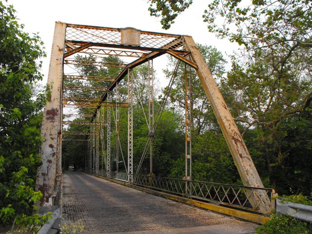
This bridge is an old and an increasingly rare example of a pin-connected Pennsylvania through truss bridge. The bridge was built to a standard design that its builder, Pittsburgh Bridge Company and its agents Nelson and Buchannan used for longer truss spans such as this. This particular bridge has excellent historic integrity is an excellent example of the company's work.
Information and Findings From Pennsylvania's Historic Bridge InventoryDiscussion of Bridge The one-span, 218'-long, pin-connected, Pennsylvania thru truss bridge is composed of built-up sections and eye bars. The bridge has built-up floorbeams with Z-plate floorbeam hangers. The open steel grid deck and stringers were placed ca. 1960. The bridge is supported on stone abutments with U-shaped wingwalls. The bridge was fabricated in 1896 by the Pittsburgh Bridge Co. and erected by their agents Nelson & Buchanan of Chambersburg. It is historically and technologically significant as one of the four oldest identified examples of Pennsylvania thru truss highway bridges, and one of only about 20 examples from 1890 to 1937 in the state. The Pennsylvania truss design, a variation of the Pratt truss with subdivided panels and polygonal upper chord, was developed in about 1875 by bridge engineers of the Pennsylvania RR. The design was used primarily for long-span railroad applications, but found some popularity for long-span (approx. 200') highway applications from about 1890 to 1910. Discussion of Surrounding Area The bridge carries a 1 lane road over a stream in a rural area of active farms. A vernacular residence (ca. 1960) is located at the bridge's southwest quadrant. Bridge Considered Historic By Survey: Yes |
![]()
![]()
![]()

![]()
![]()
Coordinates (Latitude, Longitude):
Search For Additional Bridge Listings:
Bridgehunter.com: View listed bridges within 0.5 miles (0.8 kilometers) of this bridge.
Bridgehunter.com: View listed bridges within 10 miles (16 kilometers) of this bridge.
Additional Maps:
Google Streetview (If Available)
GeoHack (Additional Links and Coordinates)
Apple Maps (Via DuckDuckGo Search)
Apple Maps (Apple devices only)
Android: Open Location In Your Map or GPS App
Flickr Gallery (Find Nearby Photos)
Wikimedia Commons (Find Nearby Photos)
Directions Via Sygic For Android
Directions Via Sygic For iOS and Android Dolphin Browser
USGS National Map (United States Only)
Historical USGS Topo Maps (United States Only)
Historic Aerials (United States Only)
CalTopo Maps (United States Only)

© Copyright 2003-2024, HistoricBridges.org. All Rights Reserved. Disclaimer: HistoricBridges.org is a volunteer group of private citizens. HistoricBridges.org is NOT a government agency, does not represent or work with any governmental agencies, nor is it in any way associated with any government agency or any non-profit organization. While we strive for accuracy in our factual content, HistoricBridges.org offers no guarantee of accuracy. Information is provided "as is" without warranty of any kind, either expressed or implied. Information could include technical inaccuracies or errors of omission. Opinions and commentary are the opinions of the respective HistoricBridges.org member who made them and do not necessarily represent the views of anyone else, including any outside photographers whose images may appear on the page in which the commentary appears. HistoricBridges.org does not bear any responsibility for any consequences resulting from the use of this or any other HistoricBridges.org information. Owners and users of bridges have the responsibility of correctly following all applicable laws, rules, and regulations, regardless of any HistoricBridges.org information.
![]()