

View Information About HSR Ratings
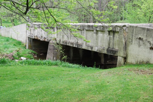
This is one of the oldest concrete girder bridges in Pennsylvania. Built in 1909, reinforced concrete was still the "new thing" in bridge construction. This bridge is an important early example of the concrete through girder and a surviving pre-1910 concrete bridge.
Information and Findings From Pennsylvania's Historic Bridge InventoryDiscussion of Bridge The 2 span, 76'-long, reinforced concrete thru girder bridge built in 1909 is supported on concrete pier and abutments with flared wingwalls surmounted by concrete parapets. The girders support floorbeams and a slab deck. Although the reinforced concrete thru girder bridge type was one of the least successful reinforced concrete bridge types developed during the first decade of the 20th century, it was used by a select number of Pennsylvania county engineers for the improvement of local roads and bridges. At least 24 of the 65 surviving examples from 1906 to 1930 in Pennsylvania are located in Lancaster County where its use was forwarded by County Engineer F. H. Shaw. This bridge is an early prototypical example by Shaw and contractor Andrew Buchanan of Chambersburg. The 1909 reinforced concrete thru girder bridge is historically and technologically distinguished as one of the two earliest extant examples of its type in the county and among the 5 oldest pre- 1910 examples in the state. Discussion of Surrounding Area The bridge carries a 2 lane road over a stream in a rural area of active farms and scattered late 20th century residences. The setting does not have the cohesiveness or integrity of a historic district. Bridge Considered Historic By Survey: Yes |
![]()
![]()
![]()
This historic bridge has been demolished. This map is shown for reference purposes only.
Coordinates (Latitude, Longitude):
Search For Additional Bridge Listings:
Bridgehunter.com: View listed bridges within 0.5 miles (0.8 kilometers) of this bridge.
Bridgehunter.com: View listed bridges within 10 miles (16 kilometers) of this bridge.
Additional Maps:
Google Streetview (If Available)
GeoHack (Additional Links and Coordinates)
Apple Maps (Via DuckDuckGo Search)
Apple Maps (Apple devices only)
Android: Open Location In Your Map or GPS App
Flickr Gallery (Find Nearby Photos)
Wikimedia Commons (Find Nearby Photos)
Directions Via Sygic For Android
Directions Via Sygic For iOS and Android Dolphin Browser
USGS National Map (United States Only)
Historical USGS Topo Maps (United States Only)
Historic Aerials (United States Only)
CalTopo Maps (United States Only)

© Copyright 2003-2024, HistoricBridges.org. All Rights Reserved. Disclaimer: HistoricBridges.org is a volunteer group of private citizens. HistoricBridges.org is NOT a government agency, does not represent or work with any governmental agencies, nor is it in any way associated with any government agency or any non-profit organization. While we strive for accuracy in our factual content, HistoricBridges.org offers no guarantee of accuracy. Information is provided "as is" without warranty of any kind, either expressed or implied. Information could include technical inaccuracies or errors of omission. Opinions and commentary are the opinions of the respective HistoricBridges.org member who made them and do not necessarily represent the views of anyone else, including any outside photographers whose images may appear on the page in which the commentary appears. HistoricBridges.org does not bear any responsibility for any consequences resulting from the use of this or any other HistoricBridges.org information. Owners and users of bridges have the responsibility of correctly following all applicable laws, rules, and regulations, regardless of any HistoricBridges.org information.
![]()