

View Information About HSR Ratings

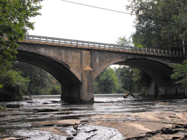
As the historic bridge inventory has mentioned, this bridge has been altered by the loss of its railings and the cantilevering of the deck sections. However, should these alterations result in the determination of "not eligible" as the inventory has done? Initially, this might seem to be appropriate. There certainly are many larger, older, and/or longer arch bridges in Pennsylvania with better historic integrity. But their is a certain irony in condemning a bridge because it is altered in this manner. Often, when a National Register Eligible historic concrete arch bridge is to be rehabilitated, the plans include the removal of the deck, the widening of the deck with cantilevers, and replacement of the original railings... exactly the same things that were done with this bridge and resulting in a bridge that is equally altered, yet these projects are called historic preservation. It is true that often these historic bridge rehabilitation projects would install railings that were more attractive and perhaps even replicate the design of the historic bridge.
The point in making these observations is not to suggest that a project that widens a historic concrete arch bridge and replaces its railings is not worth doing. Sometimes there is no way around the fact that stronger railings and a wider deck are needed to meet the needs of the roadway, and there are a number of historic projects which do this in a very careful manner that tries to be respectful of the original design of the bridge and does look nice when complete. And certainly such a project would be far more preferable to demolition and replacement. Further, it is not the point of making these observations to suggest that all concrete arch bridges like the Doughertys Mills Bridge that lack historic integrity and have lost much of their original material and design should all be considered eligible for the National Register. The point is that in both of these areas, restraint should be practiced. It needs to be realized that widening a historic concrete arch bridge will reduce the historic integrity of the bridge, and so careful consideration should be made before moving forward with such a project. Similarly, historic bridge inventories should carefully consider the value of a concrete arch bridge with a widened deck and lost railings before writing it off as not eligible.
In the case of the Doughertys Mills Bridge, original plans for the bridge survive that detail the exact design of the railings, as shown in the adaptation at the top of this narrative. If the bridge were rehabilitated, the current railings could be replaced with railings that replicate the original design. Many concrete balustrades like the ones outlined in the plans for this bridge can have their dimensions and reinforcing changed slightly to make them crash-worthy while also retaining the original appearance. Such a rehabilitation project would result in a final product similar to many historic bridge preservation projects elsewhere. As such, it would seem inappropriate to consider this bridge not eligible on the basis of its deck and railing alterations, given that a rehabilitation project would result in a product that would normally be considered acceptable on a historic concrete arch bridge. Another reason why careful consideration should be given to writing off a bridge as not eligible for the National Register of Historic Places is that without eligibility, there is no requirement for PennDOT to consider alternatives to demolition and replacement. It is hard enough to get an eligible bridge preserved, even if it might represent a cost savings over replacement, with the Section 106 process trying to help save a historic bridge, so think how hard it is to get a bridge preserved without Section 106.
Historic or not, the Doughertys Mills Bridge is to be demolished and replaced. This will deal a serious blow to the beauty of the location, which includes Rock Falls Park. From the park, one can enjoy a beautiful view of the appropriately named rocky creek with the graceful arches passing overhead. The replacement bridge will be a slab of concrete and steel, totally devoid of any heritage or aesthetic value. Rather than an asset to the beauty of the area, the replacement bridge will instead be a detriment.
A final note is that a portion of stone abutments from what appears to be a previous bridge were noted on the southeast corner of the arch bridge's abutments.
Information and Findings From Pennsylvania's Historic Bridge InventoryDiscussion of Bridge The 1929, 2 span, 140'-long reinforced concrete deck arch bridge was built in 1929 by the state highway department. It has plain spandrels. The original deck was removed and the present deck with cantilevered sections was placed in 1976. The original railings were removed and replaced with modern beam guiderail railings at that time. The bridge is an altered example of what by 1929 was a common technology. Neither the bridge nor its setting are historically or technologically distinguished. Discussion of Surrounding Area The bridge carries a 2 lane road over a stream in a sparsely developed, rural area with scattered 19th- and 20th century residences. The majority of the housing dates from after WW II. The area does appear to have historic district potential. Bridge Considered Historic By Survey: No |
![]()
![]()
![]()
This historic bridge has been demolished. This map is shown for reference purposes only.
Coordinates (Latitude, Longitude):
Search For Additional Bridge Listings:
Bridgehunter.com: View listed bridges within 0.5 miles (0.8 kilometers) of this bridge.
Bridgehunter.com: View listed bridges within 10 miles (16 kilometers) of this bridge.
Additional Maps:
Google Streetview (If Available)
GeoHack (Additional Links and Coordinates)
Apple Maps (Via DuckDuckGo Search)
Apple Maps (Apple devices only)
Android: Open Location In Your Map or GPS App
Flickr Gallery (Find Nearby Photos)
Wikimedia Commons (Find Nearby Photos)
Directions Via Sygic For Android
Directions Via Sygic For iOS and Android Dolphin Browser
USGS National Map (United States Only)
Historical USGS Topo Maps (United States Only)
Historic Aerials (United States Only)
CalTopo Maps (United States Only)

© Copyright 2003-2024, HistoricBridges.org. All Rights Reserved. Disclaimer: HistoricBridges.org is a volunteer group of private citizens. HistoricBridges.org is NOT a government agency, does not represent or work with any governmental agencies, nor is it in any way associated with any government agency or any non-profit organization. While we strive for accuracy in our factual content, HistoricBridges.org offers no guarantee of accuracy. Information is provided "as is" without warranty of any kind, either expressed or implied. Information could include technical inaccuracies or errors of omission. Opinions and commentary are the opinions of the respective HistoricBridges.org member who made them and do not necessarily represent the views of anyone else, including any outside photographers whose images may appear on the page in which the commentary appears. HistoricBridges.org does not bear any responsibility for any consequences resulting from the use of this or any other HistoricBridges.org information. Owners and users of bridges have the responsibility of correctly following all applicable laws, rules, and regulations, regardless of any HistoricBridges.org information.
![]()