

View Information About HSR Ratings
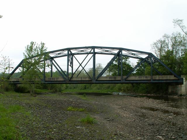
This bridge is painted an unusual purple color. It is a representative example of a standard plan bridge design that was built throughout Pennsylvania with frequency from 1920-1941. The practice of building these bold and attractive structures would ensure that no drive on a Pennsylvania highway would be without something interesting to look for decades to come. Now, as these bridges begin to age, it is time to re-evaluate these bridges to recognize their increasing rarity as PennDOT moves to demolish many of them, and seek their preservation. They are strong, sturdy structures that if preserved would continue to be viable for decades to come. The East Troy Bridge is a perfect example.
Information and Findings From Pennsylvania's Historic Bridge InventoryDiscussion of Bridge The single span, 192'-long riveted Parker thru truss is supported on concrete abutments. The top and bottom chords are built-up members. Rolled beam sections are used for the vertical and diagonal truss members. Rolled floorbeams and stringers support the concrete deck, which was replaced in 1988. Concrete barriers were constructed at that time, and numerous repairs to the steel truss were made. The 1941 bridge is a late and altered example of its type, which was widely used since the late 1920s throughout the state. Promoted in the 1910s and 1920s as the Roosevelt Highway, one of many tourist trails in the state, the highway was designated as US 6 in 1928, and named as the Pennsylvania section of the Grand Army of the Republic highway in 1948. US 6 has never been a principal east-west road. It is noted for its scenic vistas and low traffic volumes that has limited post-World War II improvements. The highway itself is not a historic district. Discussion of Surrounding Area The bridge carries a 2 lane state highway, US 6, over a stream east of the village of East Troy. The setting is predominantly wooded, and it does not appear to have historic district potential. Developed beginning in the early 19th century, SR 6 became part of the state highway system in 1911 and was improved to state standards in the 1920s. The highway itself is not a historic district. Bridge Considered Historic By Survey: No Information From Skelly and Loy Demolition Mitigation WebsiteThis riveted Parker thru truss bridge is 192' long. The Pennsylvania State Highway Department is attributed with its fabrication in 1941. It is a single span bridge supported on concrete abutments. The top and bottom chords are built up members. The vertical and diagonal truss members are rolled beams. The concrete deck was replaced in 1988, and is supported by rolled floorbeams and stringers. This bridge has been determined not eligible for listing in the National Register of Historic Places. |
![]()
![]()
Coordinates (Latitude, Longitude):
Search For Additional Bridge Listings:
Bridgehunter.com: View listed bridges within 0.5 miles (0.8 kilometers) of this bridge.
Bridgehunter.com: View listed bridges within 10 miles (16 kilometers) of this bridge.
Additional Maps:
Google Streetview (If Available)
GeoHack (Additional Links and Coordinates)
Apple Maps (Via DuckDuckGo Search)
Apple Maps (Apple devices only)
Android: Open Location In Your Map or GPS App
Flickr Gallery (Find Nearby Photos)
Wikimedia Commons (Find Nearby Photos)
Directions Via Sygic For Android
Directions Via Sygic For iOS and Android Dolphin Browser
USGS National Map (United States Only)
Historical USGS Topo Maps (United States Only)
Historic Aerials (United States Only)
CalTopo Maps (United States Only)

© Copyright 2003-2024, HistoricBridges.org. All Rights Reserved. Disclaimer: HistoricBridges.org is a volunteer group of private citizens. HistoricBridges.org is NOT a government agency, does not represent or work with any governmental agencies, nor is it in any way associated with any government agency or any non-profit organization. While we strive for accuracy in our factual content, HistoricBridges.org offers no guarantee of accuracy. Information is provided "as is" without warranty of any kind, either expressed or implied. Information could include technical inaccuracies or errors of omission. Opinions and commentary are the opinions of the respective HistoricBridges.org member who made them and do not necessarily represent the views of anyone else, including any outside photographers whose images may appear on the page in which the commentary appears. HistoricBridges.org does not bear any responsibility for any consequences resulting from the use of this or any other HistoricBridges.org information. Owners and users of bridges have the responsibility of correctly following all applicable laws, rules, and regulations, regardless of any HistoricBridges.org information.
![]()