

View Information About HSR Ratings
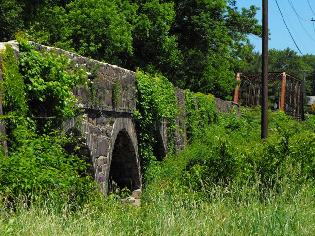
This beautiful bridge is a truly unique structure. On its own, the through truss main span is an attractive, traditionally composed example of its type, made noteworthy by its being a documented example of a bridge built by local bridge company Eyre Construction Company. But it is the addition of the stone approach system that truly makes this bridge unique. For the creek it crosses and the design of the main span, the 300+ foot stone arch approach is somewhat of a suprise. The design of the approach is itself unusual aside from its length, it consists of six stone arch spans prsented in two groups of three. The stone arch groups are seperated from each other, the main span, and the western end of the bridge by sections of earthen causeway which is held by stone retaining walls. The unusual design of this bridge is to accomodate the nature of the creek at this location, which splits at this point to form a small, low-lying island. The truss span crosses the largest channel on the east end, while one of the stone arch groups crosses the narrower channel, and the other stone arch group serves to accomodate the island which is also flood plain.
This bridge was rehabilitated in 1962-1963 as well as in 1999.
Information and Findings From Pennsylvania's Historic Bridge InventoryDiscussion of Bridge The 626'-long and 16'-wide bridge is really a stone viaduct with two, 3-span stone arch spans and a 110'-long, pin connected, Pratt thru truss main span that carries the roadway over two streams and related flood plain. The two 78'-long, three span, stone arch sections have coursed, dressed red-colored stone spandrel walls and stepped parapets originally finished with bluestone cap stones. The truss bridge is traditionally composed with the floor beams above the lower chords. The 1905 viaduct is a late example of both bridge technologies, but it is historically and technologically significant as a complete example of a stone arch bridge built in the early 20th century in Montgomery County. It represents better than most other extant examples of the technical and aesthetic preferences of the county at the turn of the century. Twenty one of the 57 extant stone arch bridges in the county were built in the 20th century. Discussion of Surrounding Area The bridge carries one lane of a county road over two streams and a flood plain in a rural area that is redeveloping with modern houses. The East Greenville waterworks buildings (1894 and 1939) are at the east side of the long bridge. The waterworks may be a potential historic district. Bridge Considered Historic By Survey: Yes |
![]()
![]()
![]()
Coordinates (Latitude, Longitude):
Search For Additional Bridge Listings:
Bridgehunter.com: View listed bridges within 0.5 miles (0.8 kilometers) of this bridge.
Bridgehunter.com: View listed bridges within 10 miles (16 kilometers) of this bridge.
Additional Maps:
Google Streetview (If Available)
GeoHack (Additional Links and Coordinates)
Apple Maps (Via DuckDuckGo Search)
Apple Maps (Apple devices only)
Android: Open Location In Your Map or GPS App
Flickr Gallery (Find Nearby Photos)
Wikimedia Commons (Find Nearby Photos)
Directions Via Sygic For Android
Directions Via Sygic For iOS and Android Dolphin Browser
USGS National Map (United States Only)
Historical USGS Topo Maps (United States Only)
Historic Aerials (United States Only)
CalTopo Maps (United States Only)

© Copyright 2003-2024, HistoricBridges.org. All Rights Reserved. Disclaimer: HistoricBridges.org is a volunteer group of private citizens. HistoricBridges.org is NOT a government agency, does not represent or work with any governmental agencies, nor is it in any way associated with any government agency or any non-profit organization. While we strive for accuracy in our factual content, HistoricBridges.org offers no guarantee of accuracy. Information is provided "as is" without warranty of any kind, either expressed or implied. Information could include technical inaccuracies or errors of omission. Opinions and commentary are the opinions of the respective HistoricBridges.org member who made them and do not necessarily represent the views of anyone else, including any outside photographers whose images may appear on the page in which the commentary appears. HistoricBridges.org does not bear any responsibility for any consequences resulting from the use of this or any other HistoricBridges.org information. Owners and users of bridges have the responsibility of correctly following all applicable laws, rules, and regulations, regardless of any HistoricBridges.org information.
![]()