

View Information About HSR Ratings
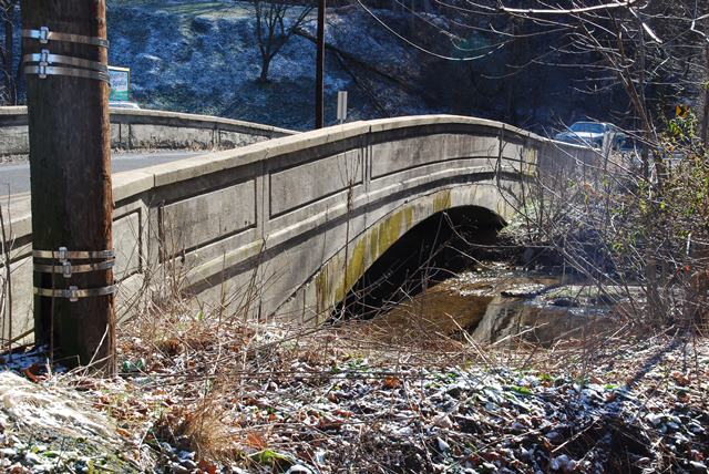
This small concrete arch bridge is noted as a very early surviving example of its type in the region.
Information and Findings From Pennsylvania's Historic Bridge InventoryDiscussion of Bridge The single span, 50'-long reinforced concrete deck arch bridge is finished with concrete parapets with scored panels. The spandrel walls are plain save for scoring that accents the arch shape. The reinforced concrete deck arch bridge designed by the Berks County Engineer's Office was erected in 1907. The bridge is historically and technologically significant within the local context as a documented, early example of its type and design, which was used by Berks County with great frequency through the 1930s. It is one of 25 reinforced concrete deck arch bridges in the county dating from 1902 to 1936 and ranks as the second oldest extant example (criterion C). The use of reinforced concrete for closed spandrel arch bridges was introduced in this country about 1890. Although American engineers were familiar with a combination of concrete and reinforcing by about 1870, it took another 30 years of experimentation and theoretical and empirical investigations before engineers and builders had a mature understanding of the capabilities and versatility of the material. Once understood, the technology was quickly embraced, and by 1910, the elliptical-shaped, deck arch bridge, where the road is at or near the crown of the arch, was ubiquitous. Reinforced concrete arches offered an economical and relatively low maintenance alternative to steel truss bridges, and because of the moldable qualities of the material, the spandrel walls and railings could be architectonically detailed, frequently in the classical taste. The technology was immediately popular with some county and city engineers, and over 55 examples from before 1910 survive throughout the state. Over 200 examples from before 1916 survive, and 270 reinforced concrete closed spandrel arch bridges predate 1920. It is the early examples of the technology in the county like this one that represent its significance in the local and state context. The bridge is evaluated as individually significant. The significant boundary is the superstructure and substructure. Discussion of Surrounding Area The bridge carries a 2 lane road over a stream in a sparsely developed, rural area with scattered 20th-century residences and a waste water treatment plant. A railroad overpass is beyond the west side of the bridge. The area does not have historic district potential. Bridge Considered Historic By Survey: Yes |
This bridge is tagged with the following special condition(s): Unorganized Photos
![]()
![]()
![]()
Coordinates (Latitude, Longitude):
Search For Additional Bridge Listings:
Bridgehunter.com: View listed bridges within 0.5 miles (0.8 kilometers) of this bridge.
Bridgehunter.com: View listed bridges within 10 miles (16 kilometers) of this bridge.
Additional Maps:
Google Streetview (If Available)
GeoHack (Additional Links and Coordinates)
Apple Maps (Via DuckDuckGo Search)
Apple Maps (Apple devices only)
Android: Open Location In Your Map or GPS App
Flickr Gallery (Find Nearby Photos)
Wikimedia Commons (Find Nearby Photos)
Directions Via Sygic For Android
Directions Via Sygic For iOS and Android Dolphin Browser
USGS National Map (United States Only)
Historical USGS Topo Maps (United States Only)
Historic Aerials (United States Only)
CalTopo Maps (United States Only)

© Copyright 2003-2024, HistoricBridges.org. All Rights Reserved. Disclaimer: HistoricBridges.org is a volunteer group of private citizens. HistoricBridges.org is NOT a government agency, does not represent or work with any governmental agencies, nor is it in any way associated with any government agency or any non-profit organization. While we strive for accuracy in our factual content, HistoricBridges.org offers no guarantee of accuracy. Information is provided "as is" without warranty of any kind, either expressed or implied. Information could include technical inaccuracies or errors of omission. Opinions and commentary are the opinions of the respective HistoricBridges.org member who made them and do not necessarily represent the views of anyone else, including any outside photographers whose images may appear on the page in which the commentary appears. HistoricBridges.org does not bear any responsibility for any consequences resulting from the use of this or any other HistoricBridges.org information. Owners and users of bridges have the responsibility of correctly following all applicable laws, rules, and regulations, regardless of any HistoricBridges.org information.
![]()