

View Information About HSR Ratings
This bridge was historic on multiple levels. It was an important contributing element to the historic Pennsylvania Railroad main line. Aside from the physical footprint and right-of-way of the railroad line itself, bridges such as the Leger Road Bridge are among the most tangible and important surviving remnants of a historic railroad line. The rails themselves, the railroad ties, and gravel that make up the railroad are mundane elements that have changed little over the past century. Therefore, the historic feel of a historic railroad line is rendered by the preservation of tangible structures such as the Leger Road Bridge.
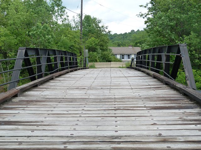
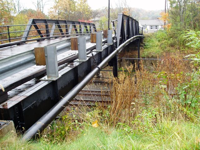
The bridge was noteworthy in appearance and design for its configuration consisting of a main pony truss span flanked with a girder approach span on either end, as well as for its substructure which included attractive riveted steel bents with bracing. Perhaps one of the most surprising and unique features of the bridge was its railings. While the pole railings it contained were nothing unusual for the period, the ornate cast iron posts at the ends of the railings were extremely unique and very beautiful.
None of this mattered to PennDOT however, who chose to demolish and replace the historic bridge with a slab of concrete. It is doubtful that even the beautiful cast iron railing posts survived the dumpster. At the very least, these posts should have been salvaged and placed near the replacement bridge to stand as reminders of heritage (and preservation opportunities) lost.
Information and Findings From Pennsylvania's Historic Bridge InventoryDiscussion of Bridge The 3 simple span bridge consists of a 62' long riveted, Warren with verticals pony truss main span and 28' long built up deck girder approach spans. The substructure consists of ashlar abutments topped with concrete seats and built up 2 column bents. The truss is a standard PRR design composed of angles and plate. The design was used since the late 19th century. The bridge, which appears to be complete, is finished with three-high pipe railings with cast iron end posts. The stringers and deck are wood. The bridge is historically significant in association with the Pennsylvania RR main line. It is a complete example of their commonly used grade crossing elimination bridge of the period. American Bridge Co. fabricated many bridges for the railroad company. Discussion of Surrounding Area The bridge carries a 2 lane road over 2 tracks of the Conrail/Amtrak (formerly Pennsylvania Railroad main line) and an access road in an area of predominently post-World War II houses. PHMC has determined the PRR main line in Pennsylvania eligible. Bridge Considered Historic By Survey: Yes |
This bridge is tagged with the following special condition(s): Unorganized Photos
![]()
![]()
![]()
![]()
![]()
Coordinates (Latitude, Longitude):
Search For Additional Bridge Listings:
Bridgehunter.com: View listed bridges within 0.5 miles (0.8 kilometers) of this bridge.
Bridgehunter.com: View listed bridges within 10 miles (16 kilometers) of this bridge.
Additional Maps:
Google Streetview (If Available)
GeoHack (Additional Links and Coordinates)
Apple Maps (Via DuckDuckGo Search)
Apple Maps (Apple devices only)
Android: Open Location In Your Map or GPS App
Flickr Gallery (Find Nearby Photos)
Wikimedia Commons (Find Nearby Photos)
Directions Via Sygic For Android
Directions Via Sygic For iOS and Android Dolphin Browser
USGS National Map (United States Only)
Historical USGS Topo Maps (United States Only)
Historic Aerials (United States Only)
CalTopo Maps (United States Only)

© Copyright 2003-2024, HistoricBridges.org. All Rights Reserved. Disclaimer: HistoricBridges.org is a volunteer group of private citizens. HistoricBridges.org is NOT a government agency, does not represent or work with any governmental agencies, nor is it in any way associated with any government agency or any non-profit organization. While we strive for accuracy in our factual content, HistoricBridges.org offers no guarantee of accuracy. Information is provided "as is" without warranty of any kind, either expressed or implied. Information could include technical inaccuracies or errors of omission. Opinions and commentary are the opinions of the respective HistoricBridges.org member who made them and do not necessarily represent the views of anyone else, including any outside photographers whose images may appear on the page in which the commentary appears. HistoricBridges.org does not bear any responsibility for any consequences resulting from the use of this or any other HistoricBridges.org information. Owners and users of bridges have the responsibility of correctly following all applicable laws, rules, and regulations, regardless of any HistoricBridges.org information.
![]()