

View Information About HSR Ratings
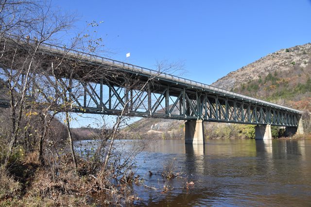
This is a large deck truss bridge located in a scenic mountain setting. In light of how many truss bridges have been demolished in Pennsylvania, the inventory finding of "not historic" should be overturned.
Information and Findings From Pennsylvania's Historic Bridge InventoryDiscussion of Bridge The 7 span, 1024'-long viaduct built in 1930 is composed of 5 Pratt deck truss spans with a single thru girder span on each end. It has a concrete substructure. In 1984, the floorbeams and stringers were replaced in the truss spans. The trusses were strengthened with bolted coverplate. The bridge was designed by the state highway department, and rolled section is used for the verticals and diagonals. It is notable for its overall size, but it is not historically or technologically significant. Deck trusses are used when there is sufficient vertical clearance. Discussion of Surrounding Area The bridge carries a 2 lane road and a sidewalk over the Lehigh River, the abandoned Lehigh Canal, and a single active railroad track on the north side of the river in a sparsely developed setting with scattered residential and commercial structures. The Lehigh Canal Historic District (listed 10/2/78) is the right-of-way of the old Lehigh Canal along the river's north bank. The district has a period of significance from 1840 to 1931, the active years of the canal. The active railroad track on the north bank of the river is operated by Conrail, and is the former Central RR of New Jersey's line from Easton to Wilkes Barre, established in the late 1860s. On the west bank of the river is the abandoned right-of-way of the Lehigh Valley RR, established in the early 1850s. Bridge Considered Historic By Survey: No |
![]()
![]()
![]()
Coordinates (Latitude, Longitude):
Search For Additional Bridge Listings:
Bridgehunter.com: View listed bridges within 0.5 miles (0.8 kilometers) of this bridge.
Bridgehunter.com: View listed bridges within 10 miles (16 kilometers) of this bridge.
Additional Maps:
Google Streetview (If Available)
GeoHack (Additional Links and Coordinates)
Apple Maps (Via DuckDuckGo Search)
Apple Maps (Apple devices only)
Android: Open Location In Your Map or GPS App
Flickr Gallery (Find Nearby Photos)
Wikimedia Commons (Find Nearby Photos)
Directions Via Sygic For Android
Directions Via Sygic For iOS and Android Dolphin Browser
USGS National Map (United States Only)
Historical USGS Topo Maps (United States Only)
Historic Aerials (United States Only)
CalTopo Maps (United States Only)

© Copyright 2003-2024, HistoricBridges.org. All Rights Reserved. Disclaimer: HistoricBridges.org is a volunteer group of private citizens. HistoricBridges.org is NOT a government agency, does not represent or work with any governmental agencies, nor is it in any way associated with any government agency or any non-profit organization. While we strive for accuracy in our factual content, HistoricBridges.org offers no guarantee of accuracy. Information is provided "as is" without warranty of any kind, either expressed or implied. Information could include technical inaccuracies or errors of omission. Opinions and commentary are the opinions of the respective HistoricBridges.org member who made them and do not necessarily represent the views of anyone else, including any outside photographers whose images may appear on the page in which the commentary appears. HistoricBridges.org does not bear any responsibility for any consequences resulting from the use of this or any other HistoricBridges.org information. Owners and users of bridges have the responsibility of correctly following all applicable laws, rules, and regulations, regardless of any HistoricBridges.org information.
![]()