

View Information About HSR Ratings
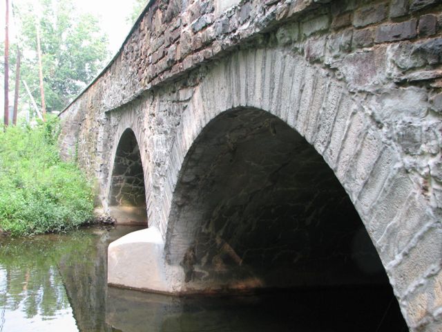
With an 1838 construction date, this bridge is not anywhere near the oldest example, yet it is among the older examples of stone arch bridges in Pennsylvania, and on a national scale it is an extremely old bridge, since many states do not have bridges anywhere near this old. This 172+ year old bridge today carries traffic on a busy road. The Average Daily Traffic is 11,971. The builders of this bridge could not have even imagined that their bridge would carry something called "motorized" traffic, nor could they have imagined the volume of this traffic that the bridge would serve. The bridge is truly a testimony to the quality of construction in these ancient stone arch bridges. The road this bridge is on, the Limekiln Pike, is itself a historic route that dates back to 1693. Appropriately named, the road was constructed to carry lime from kilns that were located in Upper Dublin Township.
The marble plaque on the bridge is of interest. It reads "Built By Montgomery County 1838 21 1/2 M. To Phil." What is interesting is that it is giving travelers a measure of distance to Philadelphia. The bridge was built in a time where there were no big reflective signs that had to be read by traffic moving at 55mph. The fact that a distance measurement to a major destination is displayed on the plaque also demonstrates the historic use of Limekiln Pike as an arterial route rather than a local street.
Information and Findings From Pennsylvania's Stone Arch Bridge Management PlanDiscussion of Bridge This bridge is not recommended for long-term preservation. It is among the lowest ranked of the stone arch bridges under study in this plan. It scored low or very low in five variables: transportation, waterway adequacy, development, values, and public input. Advanced scour was identified during the latest inspection. High traffic volumes occur on this bridge, which has a relatively narrow width. Additional growth is anticipated in the area and would result in a decreasing ability to support traffic flow. The waterway is inadequate and causes occasional flooding; the advanced scour is likely a result of the inadequate waterway. An inadequate waterway is a function of the size of the arch barrel, which is also the bridge's main structural element. Repairing the problem to enlarge the opening requires the reconstruction of the bridge. Returning the bridge to its historic appearance would be relatively expensive, as some of its historic fabric and form is missing. The recreational, historical, and cultural values and public input codes are very low, indicating a lack of significance for the bridge. Although an old example (1810), it was determined not eligible for listing in the National Register of Historic Places individually because of the alterations, including the replacement of parts of the parapets with concrete and a steel guide rail. It also does not contribute to a historic district. The bridge received no public support. Ratings The Upper Dublin, Limekiln Road Bridge is owned by
PennDOT and is ranked 122nd. Recommendation: Not recommended for long-term preservation. |
![]()
![]()
![]()
Coordinates (Latitude, Longitude):
Search For Additional Bridge Listings:
Bridgehunter.com: View listed bridges within 0.5 miles (0.8 kilometers) of this bridge.
Bridgehunter.com: View listed bridges within 10 miles (16 kilometers) of this bridge.
Additional Maps:
Google Streetview (If Available)
GeoHack (Additional Links and Coordinates)
Apple Maps (Via DuckDuckGo Search)
Apple Maps (Apple devices only)
Android: Open Location In Your Map or GPS App
Flickr Gallery (Find Nearby Photos)
Wikimedia Commons (Find Nearby Photos)
Directions Via Sygic For Android
Directions Via Sygic For iOS and Android Dolphin Browser
USGS National Map (United States Only)
Historical USGS Topo Maps (United States Only)
Historic Aerials (United States Only)
CalTopo Maps (United States Only)

© Copyright 2003-2024, HistoricBridges.org. All Rights Reserved. Disclaimer: HistoricBridges.org is a volunteer group of private citizens. HistoricBridges.org is NOT a government agency, does not represent or work with any governmental agencies, nor is it in any way associated with any government agency or any non-profit organization. While we strive for accuracy in our factual content, HistoricBridges.org offers no guarantee of accuracy. Information is provided "as is" without warranty of any kind, either expressed or implied. Information could include technical inaccuracies or errors of omission. Opinions and commentary are the opinions of the respective HistoricBridges.org member who made them and do not necessarily represent the views of anyone else, including any outside photographers whose images may appear on the page in which the commentary appears. HistoricBridges.org does not bear any responsibility for any consequences resulting from the use of this or any other HistoricBridges.org information. Owners and users of bridges have the responsibility of correctly following all applicable laws, rules, and regulations, regardless of any HistoricBridges.org information.
![]()