

View Information About HSR Ratings

This bridge is to be demolished and replaced in association with the project to replace the Strank Bridge.
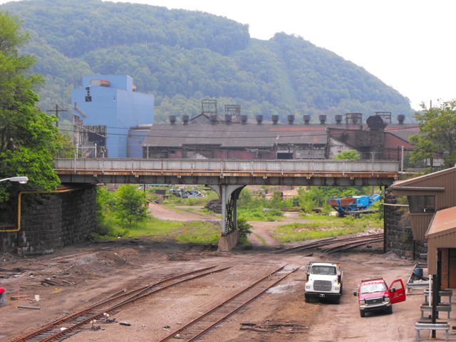
This bridge is a traditionally composed example of a riveted highway through plate girder. The center support for the bridge is a steel bent with bracing all composed of built-up beams. The abutments are stone. There is a cantilevered sidewalk on the northeast side of the girder.
The original plans for this bridge reveal a unique and interesting design feature of this bridge. The bridge was specifically designed to have one of the two spans increased in length by 20 feet at some point in the future. The bridge as originally built was to be designed so that this expansion could be spliced in at a later date. The original plans show what this expansion would look like, which HistoricBridges.org has shown in the drawing above. This would have increased the clear span distance from abutment to abutment from 116 feet to 138 feet. This was apparently done in the event that the railroad line decided to expand, something which never apparently happened. The description of this as it appeared in the original plans is shown to the right.

Information and Findings From Pennsylvania's Historic Bridge InventoryDiscussion of Bridge The 1928, 2 span, 116'-long, thru girder bridge is supported on ashlar abutments and a built up steel column and cap beam bent. It has no innovative or distinctive details. The bridge is not historically significant. It was excluded by PHMC from the boundary of the Cambria Iron Company Franklin Plant potential historic district in 1989, as was the Cambria and Blacklick Railroad yard to its east. The potential historic district stretches for nearly a mile to the southeast and concentrates on steel making operations. The bridge is not associated with the mill's steel making operations, nor was it built during any of the plant improvement campaign. Discussion of Surrounding Area The bridge carries a 2 lane street and a sidewalk over 4 tracks connecting a small C&BL RR yard with the former Franklin Works of Bethlehem Steel. The C&BL was the company's intra-plant railroad. The bridge is just northeast, and outside, of the boundary of Cambria Iron Franklin Plant potential historic district. Bridge Considered Historic By Survey: No |
![]()
![]()
![]()
This historic bridge has been demolished. This map is shown for reference purposes only.
Coordinates (Latitude, Longitude):
Search For Additional Bridge Listings:
Bridgehunter.com: View listed bridges within 0.5 miles (0.8 kilometers) of this bridge.
Bridgehunter.com: View listed bridges within 10 miles (16 kilometers) of this bridge.
Additional Maps:
Google Streetview (If Available)
GeoHack (Additional Links and Coordinates)
Apple Maps (Via DuckDuckGo Search)
Apple Maps (Apple devices only)
Android: Open Location In Your Map or GPS App
Flickr Gallery (Find Nearby Photos)
Wikimedia Commons (Find Nearby Photos)
Directions Via Sygic For Android
Directions Via Sygic For iOS and Android Dolphin Browser
USGS National Map (United States Only)
Historical USGS Topo Maps (United States Only)
Historic Aerials (United States Only)
CalTopo Maps (United States Only)

© Copyright 2003-2024, HistoricBridges.org. All Rights Reserved. Disclaimer: HistoricBridges.org is a volunteer group of private citizens. HistoricBridges.org is NOT a government agency, does not represent or work with any governmental agencies, nor is it in any way associated with any government agency or any non-profit organization. While we strive for accuracy in our factual content, HistoricBridges.org offers no guarantee of accuracy. Information is provided "as is" without warranty of any kind, either expressed or implied. Information could include technical inaccuracies or errors of omission. Opinions and commentary are the opinions of the respective HistoricBridges.org member who made them and do not necessarily represent the views of anyone else, including any outside photographers whose images may appear on the page in which the commentary appears. HistoricBridges.org does not bear any responsibility for any consequences resulting from the use of this or any other HistoricBridges.org information. Owners and users of bridges have the responsibility of correctly following all applicable laws, rules, and regulations, regardless of any HistoricBridges.org information.
![]()