

View Information About HSR Ratings

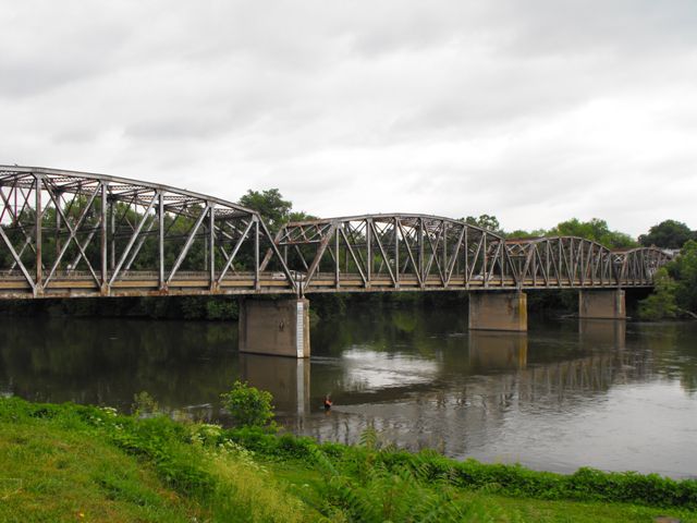
This bridge is an excellent, laregly unaltered example of a state standard truss bridge in Pennsylvania. The bridge retains original vehicular and pedestrian railings. The only major alteration is the repair of the bottom portion of truss members with bolts and plates. The bridge is an increasingly rare example of a state standard truss bridge in Pennsylvania that exceeds three spans. The larger state standard plan truss bridges have seen a higher demolition rate than some of the shorter examples. The bridge is a very attractive structure with its complex trusses, and is located right on the main street of two small communities and is positioned as such that it is easy to view and enjoy.
PennDOT wants to build a new bridge a significant distance south of the truss bridge. There is nothing really wrong with this in and of itself, however PennDOT has a habit of refusing to leave a historic bridge standing after a replacement has been built, even when the historic bridge is not in the way of its replacement. Demolishing these bridges represents a massive waste of heritage and also money, to simply demolish a bridge for no other reason than to wipe it off the face of the earth. It is frustrating enough when this sort of thing happens. However, it gets worse. Not only does PennDOT want to demolish the historic truss bridge, they want to build a pedestrian bridge in its place because many members of the local community use the bridge as pedestrians and the location of the new bridge is too far away to be useful for pedestrians. This is one of the most ridiculous things ever proposed! The existing bridge is carrying 8000+ cars a day with no posted weight limit. According to the National Bridge Inventory, there is nothing severely wrong with this bridge. HistoricBridges.org provides a detailed NBI sheets, the facts speak for themselves. Once vehicular traffic is removed from the bridge, the existing bridge would probably stand as a functional pedestrian bridge for decades with little to no work at all. There is absolutely no need to squander taxpayer dollars and destroy history by demolishing the beautiful truss bridge and constructing an expensive pre-stressed slab of concrete for pedestrian use only! Such a proposal is so absurd its hard to believe it was even considered, let alone accepted as the solution!
If nothing else, simply leave the historic bridge standing for pedestrian use as it is. And if 20 years down the road, the bridge decays to a serious point, then they could still choose to tear the bridge down and build a new bridge. At the very least, why not at least continue to use the existing bridge until its service life has ended? By the way, if instead they chose to go above and beyond the call of duty and PennDOT instead restored the existing truss bridge for pedestrian use, you could probably forget about the idea of "service life" since as long as paint was kept on it and the substructure maintained, the bridge could have an indefinite life as a pedestrian bridge.
The not eligible finding for this bridge by the Historic Bridge Inventory reflects the findings of a 1996 survey when there were many more examples of this bridge type than exist today. The bridge today should be reevaluated as eligible as an unaltered, long multi-span example of a 1930s state standard plan for truss bridges. The number of remaining examples of state standard plan truss bridges that exceed three through truss spans has dropped dramatically since 1996.
Information and Findings From Pennsylvania's Historic Bridge InventoryDiscussion of Bridge The 690'-long, steel, Parker thru truss bridge, built in 1936, is composed of four equal spans of approximately 172.5' long each. The trusses are rivet-connected and composed of standard steel members, including built-up chords and rolled-beam verticals and diagonals. The bridge is supported on concrete piers and stone abutments. A sidewalk is cantilevered off of the north side of the bridge. The concrete deck was replaced in 1972, but no other major alterations are noted. The Parker truss design dates to the 1870s and is a variation of the Pratt with a polygonal top chord. The design was used by the state highway department throughout the early to mid-20th-century as an economical alternative to other long span bridge types and designs. This example has no unusual or noteworthy features, and it is one of at least 75 identified similar bridges dating from the 1920s and 1930s. The bridge was built by the state highway department as a bridge replacement project. It is not historically distinguished by its setting, nor does it have a significant historic association with Mifflin's or Mifflintown's history of development. Discussion of Surrounding Area The bridge carries a 2-lane highway and sidewalk over the Juniata River between the towns of Mifflin and Mifflintown. A potential Mifflin commerical historic district has been identified by PHMC (DOE 3/27/90), but no exact boundaries or period of significance are established by the available information in the file. The bridge would not be within the district's boundaries, which would extend no further east than the street fronting the river adjacent to the bridge's southwest quadrant and to the 19th-century residence at its northwest quadrant. The west end of the bridge in Mifflintown is adjacent to a parking lot at its southeastern quadrant and a brick vernacular residence (1833) at its northeastern quadrant. Mifflintown is the county seat. The courthouse and square are located two blocks east of the bridge. The area surrounding the courthouse is dominated by mid-19th to early 20th century brick commercial and civic buildings. It appears to have historic district potential. Further research would be needed to establish the potential Mifflintown district's significance and boundaries. It may include the residence at the bridge's northeast quadrant, but it would not extend to the bridge or parking lot to its southeast. Bridge Considered Historic By Survey: No |
![]()

![]()

![]()
![]()
![]()

![]()
![]()
This historic bridge has been demolished. This map is shown for reference purposes only.
Coordinates (Latitude, Longitude):
Search For Additional Bridge Listings:
Bridgehunter.com: View listed bridges within 0.5 miles (0.8 kilometers) of this bridge.
Bridgehunter.com: View listed bridges within 10 miles (16 kilometers) of this bridge.
Additional Maps:
Google Streetview (If Available)
GeoHack (Additional Links and Coordinates)
Apple Maps (Via DuckDuckGo Search)
Apple Maps (Apple devices only)
Android: Open Location In Your Map or GPS App
Flickr Gallery (Find Nearby Photos)
Wikimedia Commons (Find Nearby Photos)
Directions Via Sygic For Android
Directions Via Sygic For iOS and Android Dolphin Browser
USGS National Map (United States Only)
Historical USGS Topo Maps (United States Only)
Historic Aerials (United States Only)
CalTopo Maps (United States Only)

© Copyright 2003-2024, HistoricBridges.org. All Rights Reserved. Disclaimer: HistoricBridges.org is a volunteer group of private citizens. HistoricBridges.org is NOT a government agency, does not represent or work with any governmental agencies, nor is it in any way associated with any government agency or any non-profit organization. While we strive for accuracy in our factual content, HistoricBridges.org offers no guarantee of accuracy. Information is provided "as is" without warranty of any kind, either expressed or implied. Information could include technical inaccuracies or errors of omission. Opinions and commentary are the opinions of the respective HistoricBridges.org member who made them and do not necessarily represent the views of anyone else, including any outside photographers whose images may appear on the page in which the commentary appears. HistoricBridges.org does not bear any responsibility for any consequences resulting from the use of this or any other HistoricBridges.org information. Owners and users of bridges have the responsibility of correctly following all applicable laws, rules, and regulations, regardless of any HistoricBridges.org information.
![]()