

View Information About HSR Ratings
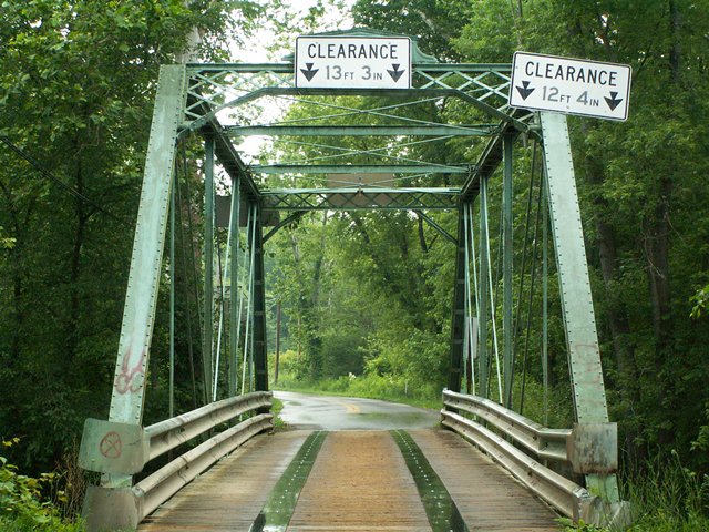
The destruction destruction of this beautiful example of the Wrought Iron Bridge Company's work is reflective of the current bridge program in Pennsylvania. Although the "program" is not stated officially, casual observers would suspect that the program involves preserving all wooden covered bridges and demolishing all metal truss bridges, regardless of historic significance, feasibility, or cost. This was a short through truss, at five panels and 80 feet. Original railings did not remain on the bridge, and two sets of ugly modern railings were added. These ugly railings could however be removed as part of a restoration and replaced with railings that would better protect the bridge while also looking nicer. A restoration of a bridge this size would likely cost less than replacement, and would allow it to continue to carry light vehicular traffic. The portal's knee bracing and at least part of the main section of portal bracing was replaced at the west end.
The replacement of this bridge was allowed only after a Section 106 Historic Review to attempt to avoid, minimize, or as a last resort mitigate adverse effect (like demolition) to the historic bridge. Pennsylvania managed to push its way through Section 106 without being forced to face the horror of saving tax dollars and preserving history through a rehabilitation of this bridge. Instead, adverse effect of replacement was found to the only feasible and prudent alternative. This meant that mitigation for the adverse effect of demolition was needed. Mitigation for the bridge was to create a website about Mercer County's truss bridges. The website address is www.mercercotrussbridges.com. Try the link, and see how it works. Its dead as of 2012! What does this mean? It means that the mitigation for demolishing a bridge that had stood for over a century, and would have stood for another century if preserved, was to create a website and let it expire after less than five years! The annual cost to keep a website the size of the mercercotrussbridges.com website would have been less than $200 per year, which is not very much money considering the cost of proper mitigation observed in other states. This is absolutely one of the worst examples of mitigation ever encountered. More than a failure to meet the spirit of Section 106, it spits in the face of the people who designed the Section 106 system. If a unique century old historic bridge is being demolished and replaced, the mitigation needs to be something that lasts for a very, very long time. Mitigation might include salvage and preservation of parts of the bridge alongside interpretive plaques for example. It could even include relocating the whole bridge somewhere, even if it sat on the ground as a non-functional exhibit. Sometimes mitigation includes a "recordation" of the bridge which involves producing a narrative about the history of the bridge and producing photographs. However, these materials are expected to be distributed to a number of places that will preserve the materials, perhaps in an archival setting. The recordation certainly would last more than a pathetic five years.
Information and Findings From Pennsylvania's Historic Bridge InventoryDiscussion of Bridge The ca. 1880, pin connected, single span, 80'-long, Pratt thru truss bridge is supported on ashlar abutments with flared wingwalls. The bridge has a number of distinctive details associated with the builder, the Wrought Iron Bridge Company, including diagonals with four-prong ends and cast guide blocks at the hip panels. The bridge is historically and technologically significant as a complete, early example of a pin connected, metal truss bridge. Adding to the significance is its association with the Wrought Iron Bridge Company, a prominent fabricator of metal truss bridges. Discussion of Surrounding Area The bridge carries a one lane road over a stream in a rural and wooded, with scattered, predominantly late, 20th century houses. Bridge Considered Historic By Survey: Yes Information From www.mercercotrussbridges.com Demolition Mitigation WebsiteDiscussion of Bridge The Pratt Through Truss bridge has a
number of distinctive details associated with the builder, the Wrought
Iron Bridge Company of Canton, Ohio, including cast guide blocks at the
lower chords of the hip panels. This bridge is slated to be removed. |
![]()
![]()
![]()
This historic bridge has been demolished. This map is shown for reference purposes only.
Coordinates (Latitude, Longitude):
Search For Additional Bridge Listings:
Bridgehunter.com: View listed bridges within 0.5 miles (0.8 kilometers) of this bridge.
Bridgehunter.com: View listed bridges within 10 miles (16 kilometers) of this bridge.
Additional Maps:
Google Streetview (If Available)
GeoHack (Additional Links and Coordinates)
Apple Maps (Via DuckDuckGo Search)
Apple Maps (Apple devices only)
Android: Open Location In Your Map or GPS App
Flickr Gallery (Find Nearby Photos)
Wikimedia Commons (Find Nearby Photos)
Directions Via Sygic For Android
Directions Via Sygic For iOS and Android Dolphin Browser
USGS National Map (United States Only)
Historical USGS Topo Maps (United States Only)
Historic Aerials (United States Only)
CalTopo Maps (United States Only)

© Copyright 2003-2024, HistoricBridges.org. All Rights Reserved. Disclaimer: HistoricBridges.org is a volunteer group of private citizens. HistoricBridges.org is NOT a government agency, does not represent or work with any governmental agencies, nor is it in any way associated with any government agency or any non-profit organization. While we strive for accuracy in our factual content, HistoricBridges.org offers no guarantee of accuracy. Information is provided "as is" without warranty of any kind, either expressed or implied. Information could include technical inaccuracies or errors of omission. Opinions and commentary are the opinions of the respective HistoricBridges.org member who made them and do not necessarily represent the views of anyone else, including any outside photographers whose images may appear on the page in which the commentary appears. HistoricBridges.org does not bear any responsibility for any consequences resulting from the use of this or any other HistoricBridges.org information. Owners and users of bridges have the responsibility of correctly following all applicable laws, rules, and regulations, regardless of any HistoricBridges.org information.
![]()