

View Information About HSR Ratings
Although this bridge is among the youngest of the stone arch bridges in Montgomery County, the bridge is still worth noting because it is nevertheless a beautiful multi-span stone arch bridge with stone parapets remaining as well, and it retains decent overall historic integrity. It has been closed to traffic and is listed as having some serious structural problems, but could probably still be preserved, something that the stone arch bridge management plan appears to confirm.
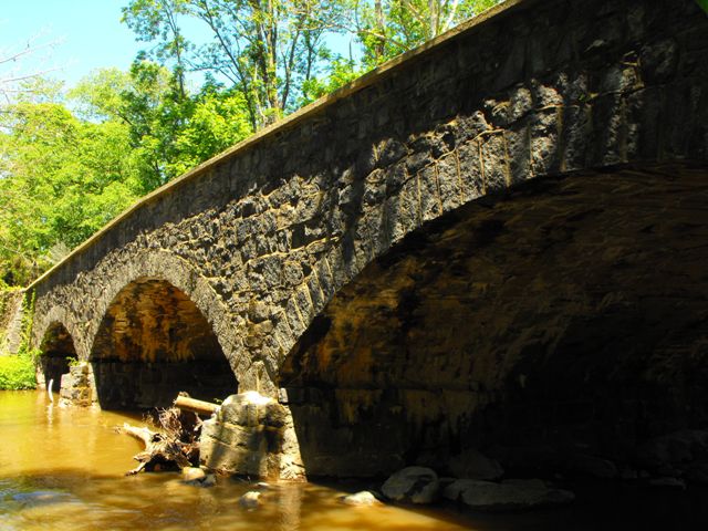
Information and Findings From Pennsylvania's Historic Bridge InventoryDiscussion of Bridge The 3-span, 97'-long and 24'-wide, stone arch bridge with asymmetrical span lengths was built in 1915 and is laid up in rubble coursed stone. The arch rings are matched stones, and the piers have cutwater nosing. The wingwalls, with parapets, are flared to accommodate adjacent intersections at both ends of the bridge. It is one of 50 stone arch bridges in the county that date from 1789 to 1919. This example is not technologically or historically significant because it is a late example of its technology in a county with a rich collection of stone arch bridges. It is located outside of any potential historic district in Zieglersville. Discussion of Surrounding Area The bridge carries a township road over a stream in a wooded setting beyond the 19th century residential core of Zieglersville. The mid-19th century houses to the west of the bridge are a potential historic district. The bridge is separated from the district visually and physically by a wooded area. It is not part of the concentration of 19th century resources that comprise the potential district. Bridge Considered Historic By Survey: Yes Information and Findings From Pennsylvania's Stone Arch Bridge Management PlanThis bridge is a moderate candidate for long-term preservation. Its condition code is very low. Structural problems, including loose stones, cracks, and scour at the piers, need to be addressed. The transportation code is moderate, a result of manageable traffic volumes and good sight distances at the approaches. However, the bridge stands in an area of rapid development, which could substantially increase traffic volumes, although a bypass carries most vehicular traffic on PA 29, a few yards to the east. The bridge’s waterway is adequate. The bridge’s historic form and fabric is intact, making the bridge relatively inexpensive to rehabilitate. The bridge is individually eligible for listing in the National Register of Historic Places. It is also part of a planned greenway. The bridge enjoys immense public support (five questionnaires, 24 letters, four emails, one petition, and one meeting at which the bridge was a primary focus). Recommendation: A moderate candidate for long-term preservation. Assessment: The Lower Frederick, Old Gravel Pike Bridge is owned
by Montgomery County and is ranked 54th. |
![]()
![]()
![]()
Coordinates (Latitude, Longitude):
Search For Additional Bridge Listings:
Bridgehunter.com: View listed bridges within 0.5 miles (0.8 kilometers) of this bridge.
Bridgehunter.com: View listed bridges within 10 miles (16 kilometers) of this bridge.
Additional Maps:
Google Streetview (If Available)
GeoHack (Additional Links and Coordinates)
Apple Maps (Via DuckDuckGo Search)
Apple Maps (Apple devices only)
Android: Open Location In Your Map or GPS App
Flickr Gallery (Find Nearby Photos)
Wikimedia Commons (Find Nearby Photos)
Directions Via Sygic For Android
Directions Via Sygic For iOS and Android Dolphin Browser
USGS National Map (United States Only)
Historical USGS Topo Maps (United States Only)
Historic Aerials (United States Only)
CalTopo Maps (United States Only)

© Copyright 2003-2024, HistoricBridges.org. All Rights Reserved. Disclaimer: HistoricBridges.org is a volunteer group of private citizens. HistoricBridges.org is NOT a government agency, does not represent or work with any governmental agencies, nor is it in any way associated with any government agency or any non-profit organization. While we strive for accuracy in our factual content, HistoricBridges.org offers no guarantee of accuracy. Information is provided "as is" without warranty of any kind, either expressed or implied. Information could include technical inaccuracies or errors of omission. Opinions and commentary are the opinions of the respective HistoricBridges.org member who made them and do not necessarily represent the views of anyone else, including any outside photographers whose images may appear on the page in which the commentary appears. HistoricBridges.org does not bear any responsibility for any consequences resulting from the use of this or any other HistoricBridges.org information. Owners and users of bridges have the responsibility of correctly following all applicable laws, rules, and regulations, regardless of any HistoricBridges.org information.
![]()