

View Information About HSR Ratings
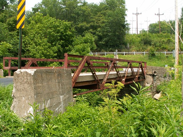
This quaint little bridge is so small that the railings are as high as the top chord! With a 1919 construction date one might be surprised to see such a small warren pony truss with riveted connections being listed with a high level of historic significance. However this is one of the first bridges to use rolled H section beams for a top chord and end post. As such the bridge is quite historic since it anticipates, well ahead of time, the transition away from built-up beams and rolled American Standard Beam style i-beams.
Information and Findings From Pennsylvania's Historic Bridge InventoryDiscussion of Bridge The 52' long and 13' wide Warren pony truss bridge dated 1919 is supported on one concrete abutment with wingwalls and one ashlar abutment. The top chords and inclined end posts are rolled H section. All other members are traditionally composed. A two rail high steel channel railing has been attached to the bridge and finished with squared ends that extend beyond the end posts. The bridge is historically and technologically significant as one of the earliest if not the earliest documented application of the rolled H section for compression members, and it is a technologically significant. There are apparently no original plans for the bridge. Discussion of Surrounding Area The bridge carries one lane of a township road over a stream. Southwest of the bridge is a large gravel pile from a stone crushing plant. North are scrub woods and fields. The area does not appear to have historic district potential. Bridge Considered Historic By Survey: Yes |
![]()
![]()
![]()
This historic bridge has been demolished. This map is shown for reference purposes only.
Coordinates (Latitude, Longitude):
Search For Additional Bridge Listings:
Bridgehunter.com: View listed bridges within 0.5 miles (0.8 kilometers) of this bridge.
Bridgehunter.com: View listed bridges within 10 miles (16 kilometers) of this bridge.
Additional Maps:
Google Streetview (If Available)
GeoHack (Additional Links and Coordinates)
Apple Maps (Via DuckDuckGo Search)
Apple Maps (Apple devices only)
Android: Open Location In Your Map or GPS App
Flickr Gallery (Find Nearby Photos)
Wikimedia Commons (Find Nearby Photos)
Directions Via Sygic For Android
Directions Via Sygic For iOS and Android Dolphin Browser
USGS National Map (United States Only)
Historical USGS Topo Maps (United States Only)
Historic Aerials (United States Only)
CalTopo Maps (United States Only)

© Copyright 2003-2024, HistoricBridges.org. All Rights Reserved. Disclaimer: HistoricBridges.org is a volunteer group of private citizens. HistoricBridges.org is NOT a government agency, does not represent or work with any governmental agencies, nor is it in any way associated with any government agency or any non-profit organization. While we strive for accuracy in our factual content, HistoricBridges.org offers no guarantee of accuracy. Information is provided "as is" without warranty of any kind, either expressed or implied. Information could include technical inaccuracies or errors of omission. Opinions and commentary are the opinions of the respective HistoricBridges.org member who made them and do not necessarily represent the views of anyone else, including any outside photographers whose images may appear on the page in which the commentary appears. HistoricBridges.org does not bear any responsibility for any consequences resulting from the use of this or any other HistoricBridges.org information. Owners and users of bridges have the responsibility of correctly following all applicable laws, rules, and regulations, regardless of any HistoricBridges.org information.
![]()