

View Information About HSR Ratings
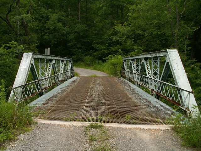
This small subdivided Warren pony truss with riveted connections, built ca. 1910 is attractive because it is has a lot of v-lacing and lattice for its design and age. V-lacing is present on the diagonals and lattice is on the verticals. There is also v-lacing under the top chord. Original lattice railings also remain on the bridge. A metal grate deck is present, although the metal grating is not the usual bridge deck style, it is more like the type used on walkways and such. The bridge is slightly skewed. It is a very rural bridge, and carries hardly any traffic. Because of this and its small size, it is hard to imagine that rehabilitating this bridge to ensure it will serve traffic for another century would be a costly endeavor.
Information and Findings From Pennsylvania's Historic Bridge InventoryDiscussion of Bridge The ca. 1910, skewed, riveted, 54'-long, Warren with verticals pony truss is supported on ashlar abutments with flared wingwalls. An example of a standardized design, the trusses have no innovative or distinctive details. The upper chords and end posts are built up box sections, and the verticals and diagonals are angles with either laced or lattice webs. The bridge is undocumented, and it is an example of the most common early 20th century pony truss design in the region and state. The technology was introduced into the state ca. 1895 and was well established by the time this bridge was built. Approximately 90 erected examples prior to 1910 survive throughout the Commonwealth. Neither the bridge nor its setting are historically or technologically significant. Discussion of Surrounding Area The bridge carries 1 lane of an unimproved township road over a stream in a sparsely developed, wooded setting that does not have rural historic district potential. Bridge Considered Historic By Survey: No |
![]()
![]()
![]()
Coordinates (Latitude, Longitude):
Search For Additional Bridge Listings:
Bridgehunter.com: View listed bridges within 0.5 miles (0.8 kilometers) of this bridge.
Bridgehunter.com: View listed bridges within 10 miles (16 kilometers) of this bridge.
Additional Maps:
Google Streetview (If Available)
GeoHack (Additional Links and Coordinates)
Apple Maps (Via DuckDuckGo Search)
Apple Maps (Apple devices only)
Android: Open Location In Your Map or GPS App
Flickr Gallery (Find Nearby Photos)
Wikimedia Commons (Find Nearby Photos)
Directions Via Sygic For Android
Directions Via Sygic For iOS and Android Dolphin Browser
USGS National Map (United States Only)
Historical USGS Topo Maps (United States Only)
Historic Aerials (United States Only)
CalTopo Maps (United States Only)

© Copyright 2003-2024, HistoricBridges.org. All Rights Reserved. Disclaimer: HistoricBridges.org is a volunteer group of private citizens. HistoricBridges.org is NOT a government agency, does not represent or work with any governmental agencies, nor is it in any way associated with any government agency or any non-profit organization. While we strive for accuracy in our factual content, HistoricBridges.org offers no guarantee of accuracy. Information is provided "as is" without warranty of any kind, either expressed or implied. Information could include technical inaccuracies or errors of omission. Opinions and commentary are the opinions of the respective HistoricBridges.org member who made them and do not necessarily represent the views of anyone else, including any outside photographers whose images may appear on the page in which the commentary appears. HistoricBridges.org does not bear any responsibility for any consequences resulting from the use of this or any other HistoricBridges.org information. Owners and users of bridges have the responsibility of correctly following all applicable laws, rules, and regulations, regardless of any HistoricBridges.org information.
![]()