

View Information About HSR Ratings
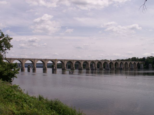
The current total length of this bridge is unknown, HAER gave a 3507 foot length for the bridge when completed, but noted that "several" arch spans had been added at the east end of the bridge, so the bridge today is a little longer.
This bridge features a staggering 51 semicircle concrete deck arch spans, three more than the famous Rockville Bridge north of Harrisburg, a stone arch bridge that was the longest stone bridge in the world when completed.
This bridge is important, just as its near-twin the Cumberland Valley Railroad Bridge is. The two bridges are together important since they offer an easy way to see how two railroads that competed with each other approached the problems associated with bridge construction.
This bridge, much like its nearby neighbor, replaced a metal truss bridge that sat on stone piers. The existing bridge's concrete piers encase these original stone abutments.
The design of the Philadelphia and Reading Railroad Bridge differs from the Cumberland Valley Railroad Bridge partially because the railroad wanted to avoid issues with floods washing out falsework which occurred with the Cumberland Valley Railroad Bridge. The design seen with the Philadelphia and Reading Railroad Bridge was one that used drastically less falsework.
![]()
![]()
![]()
Coordinates (Latitude, Longitude):
Search For Additional Bridge Listings:
Bridgehunter.com: View listed bridges within 0.5 miles (0.8 kilometers) of this bridge.
Bridgehunter.com: View listed bridges within 10 miles (16 kilometers) of this bridge.
Additional Maps:
Google Streetview (If Available)
GeoHack (Additional Links and Coordinates)
Apple Maps (Via DuckDuckGo Search)
Apple Maps (Apple devices only)
Android: Open Location In Your Map or GPS App
Flickr Gallery (Find Nearby Photos)
Wikimedia Commons (Find Nearby Photos)
Directions Via Sygic For Android
Directions Via Sygic For iOS and Android Dolphin Browser
USGS National Map (United States Only)
Historical USGS Topo Maps (United States Only)
Historic Aerials (United States Only)
CalTopo Maps (United States Only)

© Copyright 2003-2024, HistoricBridges.org. All Rights Reserved. Disclaimer: HistoricBridges.org is a volunteer group of private citizens. HistoricBridges.org is NOT a government agency, does not represent or work with any governmental agencies, nor is it in any way associated with any government agency or any non-profit organization. While we strive for accuracy in our factual content, HistoricBridges.org offers no guarantee of accuracy. Information is provided "as is" without warranty of any kind, either expressed or implied. Information could include technical inaccuracies or errors of omission. Opinions and commentary are the opinions of the respective HistoricBridges.org member who made them and do not necessarily represent the views of anyone else, including any outside photographers whose images may appear on the page in which the commentary appears. HistoricBridges.org does not bear any responsibility for any consequences resulting from the use of this or any other HistoricBridges.org information. Owners and users of bridges have the responsibility of correctly following all applicable laws, rules, and regulations, regardless of any HistoricBridges.org information.
![]()