

View Information About HSR Ratings
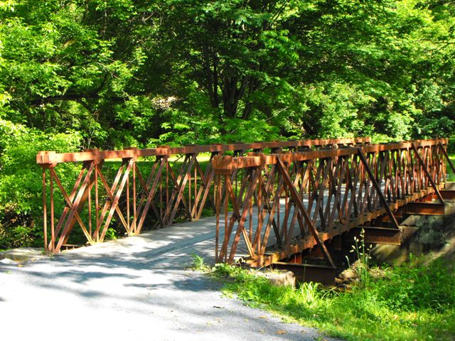
This bridge is an exceedingly rare example of a bridge with cast iron compression members, and it is independently also a rare example of a metal Howe truss bridge. The Howe truss configuration was vastly more common on wooden truss bridges such as covered bridges, and was rarely used with metal truss bridges. Bridges with cast iron compression members are one of the rarest and most significant historic bridge types in the United States. They represent the oldest metal bridges in the country and also generally exhibit unique and innovative details that demonstrate the period of experimentation that accompanied the initial use of metal in bridge construction. This bridge is no exception, with members and connection designs that are unlike any other bridges remaining today. Very little is known about the obscure builder name that Historic American Engineering Record research uncovered. As a Howe truss, the bridge contains diagonal members in compression, and these members are cast iron. There are also cast iron connection blocks.
The truss webs themselves retain excellent historic integrity, with the addition of knee braces being the only noteworthy alteration. The bridge's appearance as a whole has been significantly altered by the narrowing of the deck to an extremely narrow 7.5 foot width. Relocated back in 1980 before historic bridges, especially metal truss bridges, were a serious consideration in the historic preservation field, one cannot really condemn the fact that the bridge was made this narrow. It is lucky enough that the bridge was even saved and not demolished. However it is worth commenting that today, bridge historians would frown on decreasing the width of a bridge so drastically. It alters the design of the superstructure, and makes the bridge's proportions look incorrect, or even outright absurd. In the case of this bridge, the structure was narrowed so greatly that it is difficult for it to even serve its purpose as a non-motorized crossing. During the field visit to the bridge the trail was fairly busy, with traffic including both pedestrians and bicycles. With one person standing on the bridge admiring the historic details of the structure, a pedestrian walking across the bridge, and a bicyclist trying to get across the bridge as well, it is quite clear that 7.5 feet is not wide enough.
Generally, the reason a relocated truss bridge would be made more narrow like this would be to save on substructure (abutment and pier) costs as well as reduced deck costs. If funds are tight, a slight narrowing of some pony truss bridges may be acceptable. For example, if a pony truss with a 16 foot roadway was narrowed to 12 feet, that might not look bad. It isn't a major change in dimension, and some bridges were in fact built with 12 foot roadways. However reducing that 16 foot roadway to an 8 foot roadway (a 50% reduction) would be great enough that it would significantly affect the visual appearance of the bridge. When choosing to narrow a bridge, moderation is the best guide. It is also worth noting that if the goal is simply to save on decking costs, it is possible to place a narrower deck on a wider bridge, and simply install railings where the deck ends to contain traffic within the narrower deck. This reduces the deck costs, but retains the original bridge dimensions.
These issues aside, the bridge remains intact and in good physical condition, including maintenance of paint on the bridge.
This bridge is tagged with the following special condition(s): Reused
![]()
![]()
![]()
Coordinates (Latitude, Longitude):
Search For Additional Bridge Listings:
Bridgehunter.com: View listed bridges within 0.5 miles (0.8 kilometers) of this bridge.
Bridgehunter.com: View listed bridges within 10 miles (16 kilometers) of this bridge.
Additional Maps:
Google Streetview (If Available)
GeoHack (Additional Links and Coordinates)
Apple Maps (Via DuckDuckGo Search)
Apple Maps (Apple devices only)
Android: Open Location In Your Map or GPS App
Flickr Gallery (Find Nearby Photos)
Wikimedia Commons (Find Nearby Photos)
Directions Via Sygic For Android
Directions Via Sygic For iOS and Android Dolphin Browser
USGS National Map (United States Only)
Historical USGS Topo Maps (United States Only)
Historic Aerials (United States Only)
CalTopo Maps (United States Only)

© Copyright 2003-2024, HistoricBridges.org. All Rights Reserved. Disclaimer: HistoricBridges.org is a volunteer group of private citizens. HistoricBridges.org is NOT a government agency, does not represent or work with any governmental agencies, nor is it in any way associated with any government agency or any non-profit organization. While we strive for accuracy in our factual content, HistoricBridges.org offers no guarantee of accuracy. Information is provided "as is" without warranty of any kind, either expressed or implied. Information could include technical inaccuracies or errors of omission. Opinions and commentary are the opinions of the respective HistoricBridges.org member who made them and do not necessarily represent the views of anyone else, including any outside photographers whose images may appear on the page in which the commentary appears. HistoricBridges.org does not bear any responsibility for any consequences resulting from the use of this or any other HistoricBridges.org information. Owners and users of bridges have the responsibility of correctly following all applicable laws, rules, and regulations, regardless of any HistoricBridges.org information.
![]()