

View Information About HSR Ratings
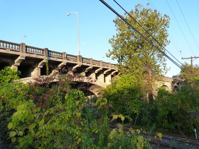
This bridge is an attractive arch bridge that also includes two concrete t-beam approach spans. The t-beam approach spans feature decoratively arched fascia beams that hide the straight nature of the interior beams. The bridge features an attractive and somewhat unusual concrete balustrade railing design.
Emos L. Seeds and John Derham Jr. of the firm Seeds and Derham of Philadelphia, Pennsylvania was the contractor for the bridge. The company was located in the Germantown area of Philadelphia.
This bridge is slated for rehabilitation.
Information and Findings From Pennsylvania's Historic Bridge InventoryDiscussion of Bridge The 7 span, 670' long, ribbed open spandrel arch bridge was built in 1924 by the county, and its handsome detailing, which includes the stylized consoles supporting the cantilevered deck sections and the Neo-Classical balustrades, reflect the tenets of the City Beautiful movement. It is one of 4 large open spandrel arch bridges built in the city, and this one is significant as one of the most handsome. Its aesthetics reflects the qualities for which the best examples of the technology are noted. Discussion of Surrounding Area The bridge carries a 2 lane city street over the Schuylkill River, River Road, and a line of the Reading RR on the northwest side of Reading. It is beyond the electric substation and turn-of-the-century rowhouse neighborhoods, and there are early to mid-19th century houses along the river. The northeast side of the bridge is dominated by a modern factory. There is a highly altered building with an 18th century nucleus beyond the northwest quadrant. The bridge was taken into the state system in 1946. Bridge Considered Historic By Survey: Yes |
![]()
![]()
![]()
Coordinates (Latitude, Longitude):
Search For Additional Bridge Listings:
Bridgehunter.com: View listed bridges within 0.5 miles (0.8 kilometers) of this bridge.
Bridgehunter.com: View listed bridges within 10 miles (16 kilometers) of this bridge.
Additional Maps:
Google Streetview (If Available)
GeoHack (Additional Links and Coordinates)
Apple Maps (Via DuckDuckGo Search)
Apple Maps (Apple devices only)
Android: Open Location In Your Map or GPS App
Flickr Gallery (Find Nearby Photos)
Wikimedia Commons (Find Nearby Photos)
Directions Via Sygic For Android
Directions Via Sygic For iOS and Android Dolphin Browser
USGS National Map (United States Only)
Historical USGS Topo Maps (United States Only)
Historic Aerials (United States Only)
CalTopo Maps (United States Only)

© Copyright 2003-2024, HistoricBridges.org. All Rights Reserved. Disclaimer: HistoricBridges.org is a volunteer group of private citizens. HistoricBridges.org is NOT a government agency, does not represent or work with any governmental agencies, nor is it in any way associated with any government agency or any non-profit organization. While we strive for accuracy in our factual content, HistoricBridges.org offers no guarantee of accuracy. Information is provided "as is" without warranty of any kind, either expressed or implied. Information could include technical inaccuracies or errors of omission. Opinions and commentary are the opinions of the respective HistoricBridges.org member who made them and do not necessarily represent the views of anyone else, including any outside photographers whose images may appear on the page in which the commentary appears. HistoricBridges.org does not bear any responsibility for any consequences resulting from the use of this or any other HistoricBridges.org information. Owners and users of bridges have the responsibility of correctly following all applicable laws, rules, and regulations, regardless of any HistoricBridges.org information.
![]()