

View Information About HSR Ratings
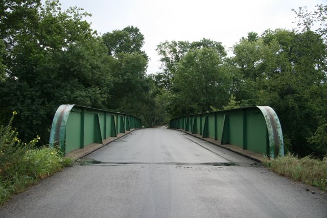
This bridge is a good way to prove that there really is a traditional plate girder hidden behind the concrete of a concrete encased metal plate girder bridge. This bridge had its concrete encasement removed in 1949, and if a visitor were not aware of this fact, the bridge otherwise looks like a typical plate girder bridge. The only visual clue to its past is that the flooring system remains encased in concrete.
Information and Findings From Pennsylvania's Historic Bridge InventoryDiscussion of Bridge The 1914, 2 span, simply supported, 182'-long, thru girder bridge is supported on concrete abutments and a concrete cutwater pier. When built, the entire bridge was encased with concrete, but the encasement was removed from all but the floorbeams and stringers in 1949. The bridge is an example of a bridge technology introduced by the railroad industry in the 1840s and used on Pennsylvania highways since the late 19th century. This example has no innovative or distinctive details. The webs of the spans are connected over the center pier by welded cover plate, but the design is not continuous because the spans are not joined at the flanges. Neither the bridge nor its setting are historically or technologically significant. Discussion of Surrounding Area The bridge carries a two lane road over a stream in a rural area with scattered, undistinguished, mid 20th century residences. Downstream of the bridge are remnants of ashlar abutments from an earlier bridge. Bridge Considered Historic By Survey: No |
![]()
![]()
![]()
Coordinates (Latitude, Longitude):
Search For Additional Bridge Listings:
Bridgehunter.com: View listed bridges within 0.5 miles (0.8 kilometers) of this bridge.
Bridgehunter.com: View listed bridges within 10 miles (16 kilometers) of this bridge.
Additional Maps:
Google Streetview (If Available)
GeoHack (Additional Links and Coordinates)
Apple Maps (Via DuckDuckGo Search)
Apple Maps (Apple devices only)
Android: Open Location In Your Map or GPS App
Flickr Gallery (Find Nearby Photos)
Wikimedia Commons (Find Nearby Photos)
Directions Via Sygic For Android
Directions Via Sygic For iOS and Android Dolphin Browser
USGS National Map (United States Only)
Historical USGS Topo Maps (United States Only)
Historic Aerials (United States Only)
CalTopo Maps (United States Only)

© Copyright 2003-2024, HistoricBridges.org. All Rights Reserved. Disclaimer: HistoricBridges.org is a volunteer group of private citizens. HistoricBridges.org is NOT a government agency, does not represent or work with any governmental agencies, nor is it in any way associated with any government agency or any non-profit organization. While we strive for accuracy in our factual content, HistoricBridges.org offers no guarantee of accuracy. Information is provided "as is" without warranty of any kind, either expressed or implied. Information could include technical inaccuracies or errors of omission. Opinions and commentary are the opinions of the respective HistoricBridges.org member who made them and do not necessarily represent the views of anyone else, including any outside photographers whose images may appear on the page in which the commentary appears. HistoricBridges.org does not bear any responsibility for any consequences resulting from the use of this or any other HistoricBridges.org information. Owners and users of bridges have the responsibility of correctly following all applicable laws, rules, and regulations, regardless of any HistoricBridges.org information.
![]()