

View Information About HSR Ratings
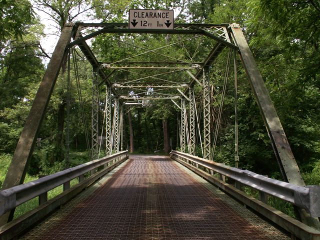
When HistoricBridges.org visited this bridge in 2008, the observation made was that this bridge was historically significant as a complete example of a rapidly disappearing bridge type built by a noteworthy company. Don't believe that this assessment? Try finding this bridge today and you will find that this bridge has itself disappeared, thanks to PennDOT who reduced this bridge to scrap metal and built an ugly modern replacement bridge. This historic bridge retained good historic integrity and would have been easy to rehabilitate, likely for less than the cost of replacement.
The Pittsburgh Bridge Company is important to Pennsylvania's heritage obviously because it is a Pennsylvania based company. It is further important because this company did most of its business within Pennsylvania. Yes, there are out-of-state examples, but the vast majority is within the state. The Wiermans Mill Road Bridge displays the distinctive details of this company's bridge design, which features several features that are consistent enough, that even without a plaque, bridges built by this company are readily identifiable. The layout of the portal bracing, while not unusual in appearance, does have a layout of its beams that is consistent with the company's work. Also, the lateral bracing connections to the sway bracing are distinctive. The connection design is one seen often with lateral bracing under the deck connected to floorbeams, but it is uncommon to find that sort of connection to the overhead sway bracing. These features are clearly visible even to casual bridge enthusiasts. A more difficult detail to understand and discern, but which is also distinctive to the Pittsburgh Bridge Company, involves the way the hangers that connect the vertical members to the floorbeams are designed. The details are described in the inventory comments below. Finally, although the plaque is gone, it left a scar in the trademark skewed shape that only Pittsburgh Bridge Company (and its agents, Nelson and Buchanan) used.
Information and Findings From Pennsylvania's Historic Bridge InventoryDiscussion of Bridge The 1 span, 93'-long, pin-connected, Pratt thru truss bridge built in 1896 is supported on stone abutments. It is composed of standard built-up section members and eye bars and has Z-shaped plate floorbeam hangers (a distinctive Pittsburgh Bridge Co. detail) and lattice portals. The timber deck was replaced by an open steel grid deck in 1960. W-beam guiderail railings have replaced earlier railings. Fabricated by the Pittsburgh Bridge Company and erected by Nelson & Buchanan of Chambersburg, the bridge is a complete example of the pin-connected Pratt truss bridge type and design that dominated highway bridge building in the late 19th century. Pin-connected truss bridges were once common in the region, but they are increasingly rare with four examples from 1889 to 1896 identified in Adams County. Of the four remaining pin-connected truss bridges, this is the only Pratt thru truss, and it was built by a noteworthy builder in the region. It is historically and technologically significant. Discussion of Surrounding Area The bridge carries 1 lane of a 2 lane road over a stream in a sparsely developed, forested rural setting. There are no buildings within sight of the bridge. Bridge Considered Historic By Survey: Yes |
![]()
![]()
![]()
This historic bridge has been demolished. This map is shown for reference purposes only.
Coordinates (Latitude, Longitude):
Search For Additional Bridge Listings:
Bridgehunter.com: View listed bridges within 0.5 miles (0.8 kilometers) of this bridge.
Bridgehunter.com: View listed bridges within 10 miles (16 kilometers) of this bridge.
Additional Maps:
Google Streetview (If Available)
GeoHack (Additional Links and Coordinates)
Apple Maps (Via DuckDuckGo Search)
Apple Maps (Apple devices only)
Android: Open Location In Your Map or GPS App
Flickr Gallery (Find Nearby Photos)
Wikimedia Commons (Find Nearby Photos)
Directions Via Sygic For Android
Directions Via Sygic For iOS and Android Dolphin Browser
USGS National Map (United States Only)
Historical USGS Topo Maps (United States Only)
Historic Aerials (United States Only)
CalTopo Maps (United States Only)

© Copyright 2003-2024, HistoricBridges.org. All Rights Reserved. Disclaimer: HistoricBridges.org is a volunteer group of private citizens. HistoricBridges.org is NOT a government agency, does not represent or work with any governmental agencies, nor is it in any way associated with any government agency or any non-profit organization. While we strive for accuracy in our factual content, HistoricBridges.org offers no guarantee of accuracy. Information is provided "as is" without warranty of any kind, either expressed or implied. Information could include technical inaccuracies or errors of omission. Opinions and commentary are the opinions of the respective HistoricBridges.org member who made them and do not necessarily represent the views of anyone else, including any outside photographers whose images may appear on the page in which the commentary appears. HistoricBridges.org does not bear any responsibility for any consequences resulting from the use of this or any other HistoricBridges.org information. Owners and users of bridges have the responsibility of correctly following all applicable laws, rules, and regulations, regardless of any HistoricBridges.org information.
![]()