

View Information About HSR Ratings
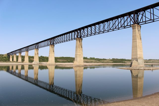
This bridge was built in 1912 using truss spans from another bridge, dating to 1887. In terms of historical significance, the bridge should be evaluated in the context of its 1887 truss spans, thus this is why the construction date is listed as such. At severe risk for collapse due to a truss being distorted, this bridge's trusses, salvaged from the famous Lachine Bridge in Montréal, are the longest Whipple truss in Canada, and indeed all of North America. Whipple deck trusses are more rare than Whipple through trusses in North America. Whipple trusses of any kind are almost unheard of in Canada. Yet this bridge remains, for now, as an enormous large-scale multi-span Whipple truss. It is over 150 feet over the river, and the concrete piers when completed in 1912 were the tallest in the world. The bridge it came from, the Lachine Bridge, was a pioneering continuous through truss bridge. The spans seen at Outlook were the simple truss approach spans of the bridge. The Outlook Railway Bridge had been converted for pedestrian use, but was closed in 2013. The reason for closure is obvious since the truss members show severe distortions. The cause of this is reported to be due to movement of the riverbed itself. Joanne David contacted HistoricBridges.org and explains the problem: The riverbed itself is moving, and in need of ecological treatment; this sloping downward to the riverbed has pushed the metal structure towards the concrete piers on the east side. This east side was deemed unsafe.
The spans of the bridge are as follows (quantity by length in feet): 6x45, 5x60, 2x80; 8x242; 3x45, 2x60, 1x80. The contractor for the 1912 substructure was J.D. McArthur & Co.
![]()
![]()
![]()
Coordinates (Latitude, Longitude):
Search For Additional Bridge Listings:
Additional Maps:
Google Streetview (If Available)
GeoHack (Additional Links and Coordinates)
Apple Maps (Via DuckDuckGo Search)
Apple Maps (Apple devices only)
Android: Open Location In Your Map or GPS App
Flickr Gallery (Find Nearby Photos)
Wikimedia Commons (Find Nearby Photos)
Directions Via Sygic For Android
Directions Via Sygic For iOS and Android Dolphin Browser

© Copyright 2003-2024, HistoricBridges.org. All Rights Reserved. Disclaimer: HistoricBridges.org is a volunteer group of private citizens. HistoricBridges.org is NOT a government agency, does not represent or work with any governmental agencies, nor is it in any way associated with any government agency or any non-profit organization. While we strive for accuracy in our factual content, HistoricBridges.org offers no guarantee of accuracy. Information is provided "as is" without warranty of any kind, either expressed or implied. Information could include technical inaccuracies or errors of omission. Opinions and commentary are the opinions of the respective HistoricBridges.org member who made them and do not necessarily represent the views of anyone else, including any outside photographers whose images may appear on the page in which the commentary appears. HistoricBridges.org does not bear any responsibility for any consequences resulting from the use of this or any other HistoricBridges.org information. Owners and users of bridges have the responsibility of correctly following all applicable laws, rules, and regulations, regardless of any HistoricBridges.org information.
![]()