

View Information About HSR Ratings
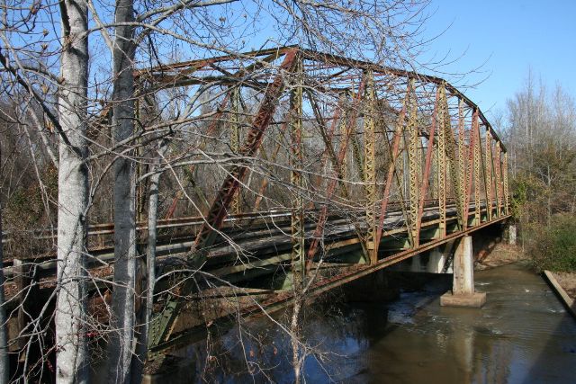
This bridge is an extremely rare example of a smaller scale truss bridge that is a continuous truss bridge, and also a continuous truss bridge that is not a cantilever truss. Most continuous truss bridges built were large monumental cantilever bridges. As such, this bridge stands out as an unusual type. The bridge is otherwise traditionally composed for a bridge may have been built after 1915 and before 1930. However, the bridge does include v-lacing on top of its built-up end posts instead of cover plate, which is uncommon. The bridge appears to retain good historic integrity with few alterations. There are stringer approach spans present at this bridge also. The bridge was bypassed by a modern bridge in 1987 and allowed to stand next to its replacement.
This bridge is locally known as the Crybaby Creek Bridge because legend says that the bridge is a "crybaby bridge" which is a group of bridges upon which paranormal events are supposedly witnessed relating to babies and/or their mothers. On this particular bridge, the sounds of a crying baby, sounds of a mother searching for her baby, or a ghost of the mother approaching visitors to see if they had her baby were supposedly possible events that could occur here. The legend apparently began with a story of a mother who jumped off the bridge with an illegitimate baby to commit suicide. These legends and stories and their truth or untruth have no bearing on the historic significance of the bridge but they do shed light on the local stories and value that can accumulate in a local community on old/historic bridges, even technologically insignificant old bridges.
Perhaps the crying sounds people supposedly hear at this bridge are the sounds of the bridge weeping for all the historic trusses that have been demolished.
HistoricBridges.org currently only has a few photos of this bridge.
![]()
![]()
![]()
Coordinates (Latitude, Longitude):
Search For Additional Bridge Listings:
Bridgehunter.com: View listed bridges within 0.5 miles (0.8 kilometers) of this bridge.
Bridgehunter.com: View listed bridges within 10 miles (16 kilometers) of this bridge.
Additional Maps:
Google Streetview (If Available)
GeoHack (Additional Links and Coordinates)
Apple Maps (Via DuckDuckGo Search)
Apple Maps (Apple devices only)
Android: Open Location In Your Map or GPS App
Flickr Gallery (Find Nearby Photos)
Wikimedia Commons (Find Nearby Photos)
Directions Via Sygic For Android
Directions Via Sygic For iOS and Android Dolphin Browser
USGS National Map (United States Only)
Historical USGS Topo Maps (United States Only)
Historic Aerials (United States Only)
CalTopo Maps (United States Only)

© Copyright 2003-2024, HistoricBridges.org. All Rights Reserved. Disclaimer: HistoricBridges.org is a volunteer group of private citizens. HistoricBridges.org is NOT a government agency, does not represent or work with any governmental agencies, nor is it in any way associated with any government agency or any non-profit organization. While we strive for accuracy in our factual content, HistoricBridges.org offers no guarantee of accuracy. Information is provided "as is" without warranty of any kind, either expressed or implied. Information could include technical inaccuracies or errors of omission. Opinions and commentary are the opinions of the respective HistoricBridges.org member who made them and do not necessarily represent the views of anyone else, including any outside photographers whose images may appear on the page in which the commentary appears. HistoricBridges.org does not bear any responsibility for any consequences resulting from the use of this or any other HistoricBridges.org information. Owners and users of bridges have the responsibility of correctly following all applicable laws, rules, and regulations, regardless of any HistoricBridges.org information.
![]()