

View Information About HSR Ratings
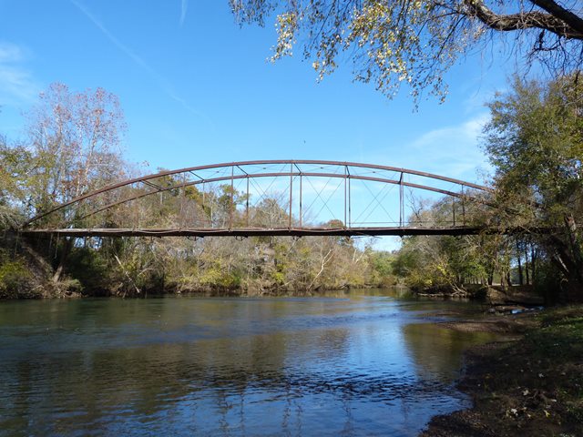
This cast and wrought iron bridge, with a 170 foot span, is one of the longest-spanning iron bowstrings in North America. It is also the longest known surviving bowstring span by the King Iron Bridge Company, one of the most prolific builders of this today-rare pioneering metal bridge type that was most popular in the 1870s. Because of its span length, this bridge should be considered to have national significance. Additional state-level significance arises from the fact that this is the only known surviving iron bowstring in Tennessee. In addition to the significance due to its size, this bowstring truss has several details not found in most surviving King Bridge Company bowstrings. The presence of lattice on the verticals is not typical for King bowstrings, and this is likely a result of the length of the atypically tall vertical members needed for the unusually long span length. The other unusual detail is the floor beams which feature a rare design including tension rods, which supplement the main part of the floor beam which is composed of two channels. A small number of King truss bridges have this detail, but it is not common, especially on bowstrings.
The bridge has been abandoned. A high priority should be placed on the full in-kind restoration of this bridge, either here, or perhaps in a new location on a trail or in a park for pedestrian use. The bridge retains good historic integrity. However, some diagonal members are damaged or have been the victims of welded alterations that likely will need to be addressed during restoration. One of the verticals also was partially broken off at the base. What is important however, is that most of the cast iron connection assemblies appear to be in good condition and remain in place on the bridge.
![]()
![]()
![]()
Coordinates (Latitude, Longitude):
Search For Additional Bridge Listings:
Bridgehunter.com: View listed bridges within 0.5 miles (0.8 kilometers) of this bridge.
Bridgehunter.com: View listed bridges within 10 miles (16 kilometers) of this bridge.
Additional Maps:
Google Streetview (If Available)
GeoHack (Additional Links and Coordinates)
Apple Maps (Via DuckDuckGo Search)
Apple Maps (Apple devices only)
Android: Open Location In Your Map or GPS App
Flickr Gallery (Find Nearby Photos)
Wikimedia Commons (Find Nearby Photos)
Directions Via Sygic For Android
Directions Via Sygic For iOS and Android Dolphin Browser
USGS National Map (United States Only)
Historical USGS Topo Maps (United States Only)
Historic Aerials (United States Only)
CalTopo Maps (United States Only)

© Copyright 2003-2024, HistoricBridges.org. All Rights Reserved. Disclaimer: HistoricBridges.org is a volunteer group of private citizens. HistoricBridges.org is NOT a government agency, does not represent or work with any governmental agencies, nor is it in any way associated with any government agency or any non-profit organization. While we strive for accuracy in our factual content, HistoricBridges.org offers no guarantee of accuracy. Information is provided "as is" without warranty of any kind, either expressed or implied. Information could include technical inaccuracies or errors of omission. Opinions and commentary are the opinions of the respective HistoricBridges.org member who made them and do not necessarily represent the views of anyone else, including any outside photographers whose images may appear on the page in which the commentary appears. HistoricBridges.org does not bear any responsibility for any consequences resulting from the use of this or any other HistoricBridges.org information. Owners and users of bridges have the responsibility of correctly following all applicable laws, rules, and regulations, regardless of any HistoricBridges.org information.
![]()