

View Information About HSR Ratings

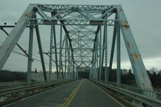
This beautiful bridge was historically significant for its large size, with a total length of 1067 feet, including an impressive concrete t-beam approach system. The main span was of decent size also, at 220 feet. Perhaps the most important aspect of this bridge however was its unusual design. Although it appeared to have been a standard plan in Tennessee, as evidenced by the similar US-41 Bridge, also potentially doomed, it was extremely unusual today both nationally and within the state. The bridge was a modification of the Parker truss, whose two centermost panels utilize a truss arrangement that was like that found on a K-truss configuration. The K-truss is a highly uncommon truss configuration, mostly found in Oklahoma and is itself a noteworthy find. This unusual blend of the two configurations was both and unusual and noteworthy. In addition, the unique design of the truss created a beautiful aesthetic design, in which a clear diamond shape was visible when the bridge's elevation was viewed from a distance.
Despite having an embarrassingly low number of remaining truss bridges, Tennessee still decided to demolish this beautiful historic bridge. Indeed, perhaps no other state has offered less of a commitment to the historic bridge community. One TNDOT official said they didn't expect than any metal truss bridges would remain in the state in the years down the road, with the exception of the Walnut Street Bridge in Chattanooga. Such a statement can mean only one thing: Tennessee intends to demolish every single highway truss bridge remaining in the state! This is an alarming statement, and highlights the need for the U.S. Congress to reinforce its declaration that preserving historic bridges is in the national interest, and expand existing limited preservation laws, that currently place little pressure on states like Tennessee to preserve their historic truss bridges.

![]()
![]()
This historic bridge has been demolished. This map is shown for reference purposes only.
Coordinates (Latitude, Longitude):
Search For Additional Bridge Listings:
Bridgehunter.com: View listed bridges within 0.5 miles (0.8 kilometers) of this bridge.
Bridgehunter.com: View listed bridges within 10 miles (16 kilometers) of this bridge.
Additional Maps:
Google Streetview (If Available)
GeoHack (Additional Links and Coordinates)
Apple Maps (Via DuckDuckGo Search)
Apple Maps (Apple devices only)
Android: Open Location In Your Map or GPS App
Flickr Gallery (Find Nearby Photos)
Wikimedia Commons (Find Nearby Photos)
Directions Via Sygic For Android
Directions Via Sygic For iOS and Android Dolphin Browser
USGS National Map (United States Only)
Historical USGS Topo Maps (United States Only)
Historic Aerials (United States Only)
CalTopo Maps (United States Only)

© Copyright 2003-2024, HistoricBridges.org. All Rights Reserved. Disclaimer: HistoricBridges.org is a volunteer group of private citizens. HistoricBridges.org is NOT a government agency, does not represent or work with any governmental agencies, nor is it in any way associated with any government agency or any non-profit organization. While we strive for accuracy in our factual content, HistoricBridges.org offers no guarantee of accuracy. Information is provided "as is" without warranty of any kind, either expressed or implied. Information could include technical inaccuracies or errors of omission. Opinions and commentary are the opinions of the respective HistoricBridges.org member who made them and do not necessarily represent the views of anyone else, including any outside photographers whose images may appear on the page in which the commentary appears. HistoricBridges.org does not bear any responsibility for any consequences resulting from the use of this or any other HistoricBridges.org information. Owners and users of bridges have the responsibility of correctly following all applicable laws, rules, and regulations, regardless of any HistoricBridges.org information.
![]()