HistoricBridges.org Menu: HistoricBridges.org Menu:


We Recommend:
Bach Steel - Experts at historic truss bridge restoration.

HistoricBridges.org: Bridge Browser

George Street Bridge

Dearborn County Bridge 159

George Street Bridge

Primary Photographer(s): Nathan Holth

Bridge Documented: July 6, 2007

View Photos
and Videos
View Maps
and Links

Facility Carried / Feature Intersected
George Street Over Hogan Creek
Location
Aurora: Dearborn County, Indiana: United States
Structure Type
Metal 16 Panel Pin-Connected Whipple (Double-Intersection Pratt) Through Truss, Fixed and Approach Spans: Metal Stringer (Multi-Beam), Fixed
Construction Date and Builder / Engineer
1887 By Builder/Contractor: Lomas Forge and Bridge Works of Cincinnati, Ohio
Rehabilitation Date
2011
Main Span Length
200.0 Feet (61 Meters)
Structure Length
254.0 Feet (77.4 Meters)
Roadway Width
23 Feet (7.01 Meters)
Spans
1 Main Span(s) and 1 Approach Span(s)
Inventory Number
1500091

Historic Significance Rating (HSR)
View Information About HSR Ratings

Bridge Documentation

View Archived National Bridge Inventory Report - Has Additional Details and Evaluation

View comments and discussion about this bridge's rehabilitations, capacity, analysis, and potential service life by engineer James Barker

2007 Observations

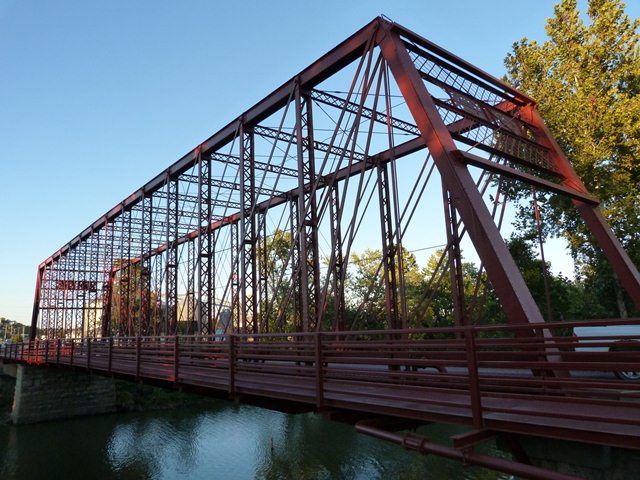
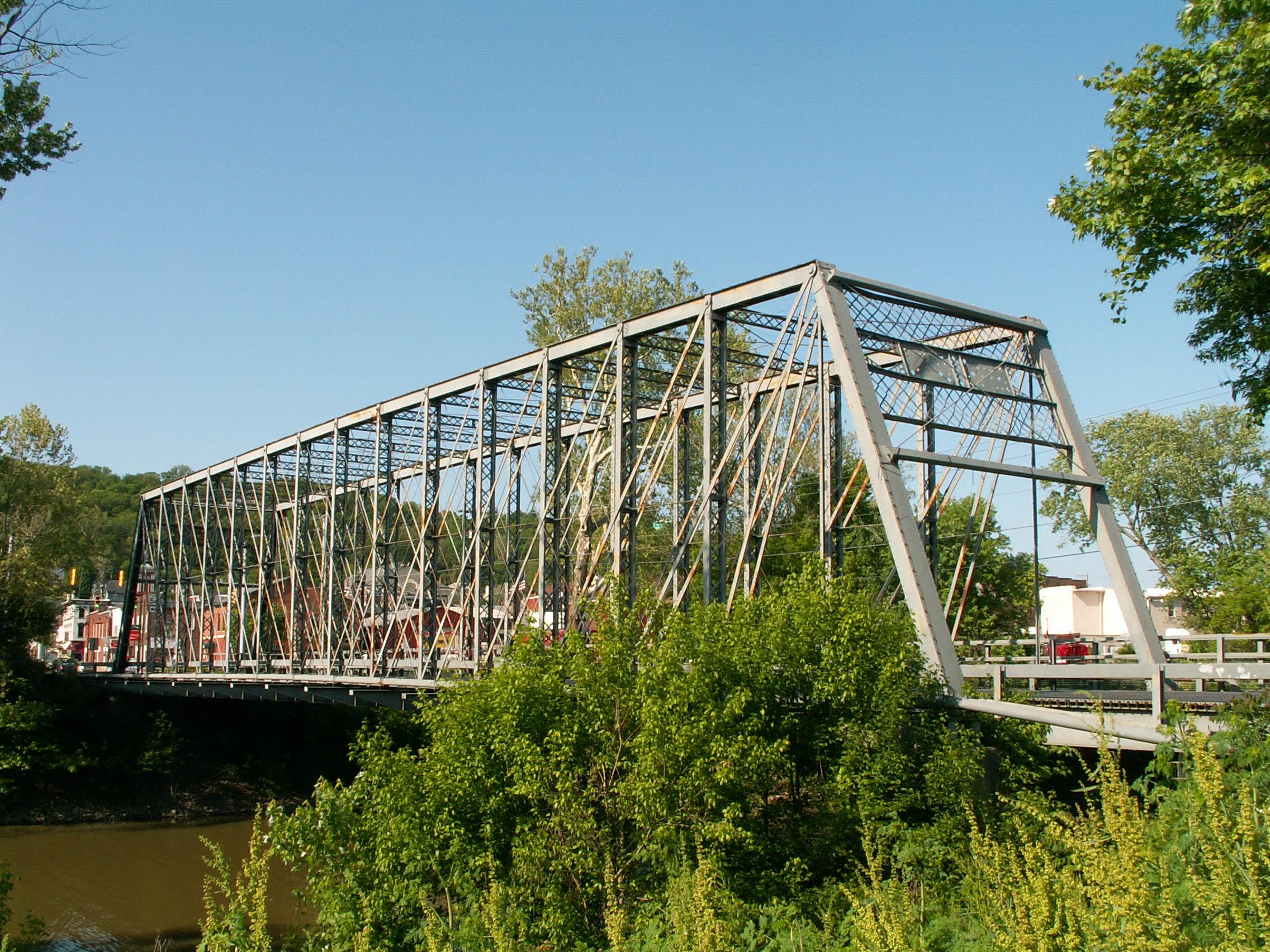
This bridge is a Whipple truss bridge, also known as the double-intersection Pratt truss. There are sixteen panels composing the bridge. The structure features pinned connections, and forms the centerpiece for the Aurora downtown area. It is nice to see a bridge being left standing for its aesthetic and historic value, and to bring interest to the downtown area of a small town. There is lattice on the sway bracing and v-lacing on the vertical members. The vertical members are unusual in that the channels that make up the built-up beams are they themselves built-up of plates and angles.

This bridge has undergone some major renovations that have allowed this beautiful structure to remain in use, at the expense of some historic integrity. Steel was welded onto the portal bracing, and the bottom chord was severed and reconnected with unusual turnbuckles. The flooring system was completely replaced, including the floor beams themselves. These were replaced with large beams that allowed pipes to be carried on one side, and a sidewalk to be added to the other. These losses to the historic integrity of the structure are rather dramatic, but on the other hand the bridge remains in use and remains a beautiful historic bridge.

The plaque on this bridge is mostly gone in a sense. The unusual plaque was made of a plate base, with the words fastened onto it. These words have since mostly fallen off.

Restoration Comments

In 2010, a high quality rehabilitation of this bridge was designed. Among the aspects of the work is the requirement that failed rivets be replaced with genuine hot-metal driven rivets, just like the bridge received when built in 1887. Typical highway rehabilitation projects replace failed rivets with historically incorrect modern high strength tension control bolts. Not only do these bolts look ugly (they lack a smooth heads on each end) they are alterations that diminish the historic integrity of the bridge. They are used because of the false believe that due to AASHTO and other regulations, the use of rivets in rehabilitation projects for bridges to carry vehicular traffic is forbidden. This is clearly not true, as the George Street Bridge proves.

Aside from other appropriate structural repairs, the project is also noteworthy because it will restore the damaged plaques to their original condition, rendering them both beautiful and legible.

This project was designed by J. A. Barker Engineering. HistoricBridges.org recommends this firm for any metal truss bridge rehabilitation project. Not only is the firm skilled in designing a project that will not reduce the historic integrity of the bridge, the project will be high quality so as to give a long service life, and will also be more cost effective than a firm that is inexperienced with historic bridges will offer.

Information and Findings From DHPA Historic Bridge Survey

Statement of Significance

Having replaced a wooden truss, this is the Forge Bridge Company's only extant structure in Indiana. The George St. Bridge carried US Highway 50 until 1950 and SR 56 until 1972, connecting Aurora's southside with its downtown. The structure retains most of its original members including its decoratively latticed portals and some of its latticed guardrail.

The George Street Bridge #159 is one of the earliest iron bridges in Indiana, and one of the few remaining metal bridges of its type in the state. The bridge is a double intersection Pratt through truss, also known as a Whipple truss for its inventor, Squire Whipple. The bridge was constructed in 1887 by the Lomas Forge and Bridge Works of Cincinnati, Ohio, and is one of only two in the state by this company. The bridge is also significant because of its prominent location in the heart of downtown Aurora, and its important role in connecting the northern part of the city with the downtown.

Whipple was a civil engineer from New York state. His highly influential book, A Work on Bridge Building (1847), was the first comprehensive American work on the design of truss bridges. In 1847, he obtained a patent for a Pratt truss variation, known as a Whipple truss, in which the diagonal supports each crossed two panels. This type of truss, of which the George Street Bridge is one, was used extensively in early iron railroad bridge construction in this country.

The George Street Bridge is one of only three Whipple trusses in Dearborn County, one of which is the triple-intersection Laughery Creek Bridge, listed on the National register in 1976. It was built by the Lomas Forge and Bridge works, with F. J. P. Brackett as engineer and construction superintendent. Brackett acquired the company in 1890, changing the name to the Brackett Bridge Company, and later, in 1918, to the Brackett Construction Company. The company was active in the Cincinnati area until the mid-1920s.

The predecessor to the present bridge greatly facilitated growth of the city by providing access to the downtown from the middle and upper class residential areas to the north, across Hogan Creek. The present bridge, which can be seen in a photo in City Hall carrying trolley cars, also carried US Highway 50 across the creek, from the highway's opening until its relocation in about 1950. It also carried Indiana Highway 56 until that route's relocation over a newer bridge in about 1972. Its proximity to the state and federal highways and to the Aurora business district has made the George Street bridge a highly visible element in the downtown, particularly since it is at the foot of Main Street.

Architectural Description

The Forge Bridge Company of Cincinnati, Ohio, fabricated this unusual two-span 258'7" structure. The main span is a double-intersection Pratt (Whipple) through truss of 199'4", divided into sixteen panels with intermediate verticals fabricated from angles riveted to plates and laced together. Cylindrical eyebars with turnbuckles serve two major functions: first; as a system to connect and stabilize the verticals at the horizontal midpoint; second, as the central diagonals. A 56'3" Pratt deck truss of five panels approaches the Whipple from the east. With verticals composed of channels connected with stay plates and diagonals of rods with turnbuckles, the approach span--like the main span--carries a steel grid deck with a 21'6" roadway and a sidewalk supported by girder floor beams U-bolted to pins.

The George Street Bridge (County Bridge #159) traverses Hogan Creek, which borders the northern edge of the original town of Aurora. The bridge, erected in 1887, provided access from the northeast to the commercial and residential buildings of Aurora's downtown, which is still a densely developed historic district. The bridge is now closed to vehicular traffic.

The George Street Bridge is an iron, double intersection Pratt, or Whipple, through truss. The single span is made up of 16 panels, each 12' 5 1/2" wide; the overall length of the truss is 199'4". Based upon measured drawings, the roadway width is 21'6", the deck width is 26'6". The truss is 33' in height.

In the main truss, top chords and endposts are channel girders fabricated from plates and angles, with bracing plates, all fastened with rivets. Bottom chords are eyebars. Posts are channel girders fabricated from plates and angles, braced with plates and intersecting, single, bar lacing fastened with rivets. Hip verticles and diagonals are eyebars; counters are rods with turnbuckles. Diagonals and counters are not joined to their intersecting verticles, but are carried free on pins bolted to the verticles. Connections at panel points are with pins. Portal bracing is paired angles and bar lattice, with name plates, fastened with rivets and extending into the truss. Top lateral struts are paired angles and single bar lattice fastened with rivets. Top and bottom lateral braces are rods with turnbuckles.

Floor beams are plate girders fabricated from plates and angles, fastened with rivets, on 12.5' centers. Wings on each beam extend 8' on either side of the trusses. Both wings carry a utility pipe. The west wings carried a pedestrian walkway until the walkway was removed, about 1974, to the bridge deck because of the deterioration of the walkway supports on the wings. Stringers are rolled I-beams 8" x 3.5" x 26', eleven across the width of the truss. They are not the originals. There is some deterioration of these stringers near both ends of the bridge. The deck is a steel grid, laid about 1950 to replace a wooden block deck. It carries a pedestrian walkway 4.5' wide, protected by a guard rail carried on channels welded to the deck. The deck also carries a sewer line on the inside of the east side of the truss. The walkway is in use, but the bridge has been closed to vehicular traffic since 1979 by channels welded across the endposts.

The truss rests on abutments of random ashlar laid with mortar. It is approached from the north by a deck truss, which has not been included in this nomination because of a loss of integrity due to severe deterioration of its structural members.

Other Information

ALTERATIONS: Some guardrails missing. The steel grid deck replaced a wooden block deck in 1950. There is severe deterioration of the structural members of the deck truss.

Bridge Considered Historic By Survey: Yes

Divider

Photo Galleries and Videos: George Street Bridge


View Photo Gallery

Bridge After 2010 Rehabilitation

Original / Full Size Photos
A collection of overview and detail photos. This gallery offers photos in the highest available resolution and file size in a touch-friendly popup viewer.
Alternatively, Browse Without Using Viewer

Divider

View Photo Gallery

Bridge After 2010 Rehabilitation

Mobile Optimized Photos
A collection of overview and detail photos. This gallery features data-friendly, fast-loading photos in a touch-friendly popup viewer.
Alternatively, Browse Without Using Viewer

Divider

View Photo Gallery

Bridge Before 2010 Rehabilitation

A collection of overview and detail photos. This photo gallery contains a combination of Original Size photos and Mobile Optimized photos in a touch-friendly popup viewer.
Alternatively, Browse Without Using Viewer

Divider

View Video

Northbound Crossing

Full Motion Video
Streaming video of the bridge. Also includes a higher quality downloadable video for greater clarity or offline viewing.

Divider

Maps and Links: George Street Bridge

Coordinates (Latitude, Longitude):

Search For Additional Bridge Listings:

Bridgehunter.com: View listed bridges within 0.5 miles (0.8 kilometers) of this bridge.

Bridgehunter.com: View listed bridges within 10 miles (16 kilometers) of this bridge.

HistoricBridges.org Bridge Browser: View listed bridges within 0.5 miles (0.8 kilometers) of this bridge.

HistoricBridges.org Bridge Browser: View listed bridges within 10 miles (16 kilometers) of this bridge.

2021 National Bridge Inventory: View listed bridges within 0.5 miles (0.8 kilometers) of this bridge.

Additional Maps:

Google Maps

Google Streetview (If Available)

Bing Maps

OpenStreetMap

GeoHack (Additional Links and Coordinates)

Apple Maps (Via DuckDuckGo Search)

Apple Maps (Apple devices only)

MapQuest

HERE We Go Maps

ACME Mapper

Waze Map

Android: Open Location In Your Map or GPS App

Flickr Gallery (Find Nearby Photos)

Wikimedia Commons (Find Nearby Photos)

Directions Via Sygic For Android

Directions Via Sygic For iOS and Android Dolphin Browser

USGS National Map (United States Only)

Historical USGS Topo Maps (United States Only)

Historic Aerials (United States Only)

CalTopo Maps (United States Only)


Divider
 
Home Top

Divider

About - Contact

© Copyright 2003-2024, HistoricBridges.org. All Rights Reserved. Disclaimer: HistoricBridges.org is a volunteer group of private citizens. HistoricBridges.org is NOT a government agency, does not represent or work with any governmental agencies, nor is it in any way associated with any government agency or any non-profit organization. While we strive for accuracy in our factual content, HistoricBridges.org offers no guarantee of accuracy. Information is provided "as is" without warranty of any kind, either expressed or implied. Information could include technical inaccuracies or errors of omission. Opinions and commentary are the opinions of the respective HistoricBridges.org member who made them and do not necessarily represent the views of anyone else, including any outside photographers whose images may appear on the page in which the commentary appears. HistoricBridges.org does not bear any responsibility for any consequences resulting from the use of this or any other HistoricBridges.org information. Owners and users of bridges have the responsibility of correctly following all applicable laws, rules, and regulations, regardless of any HistoricBridges.org information.

Admin Login

Divider