

View Information About HSR Ratings
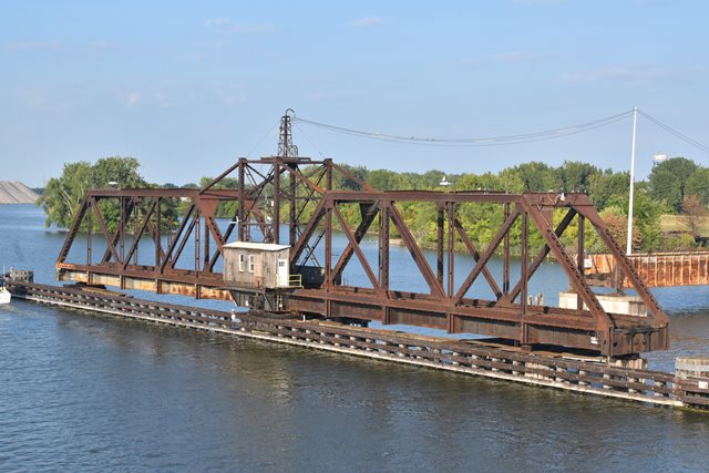
This bridge is similar, but not the same, as the Saginaw Railroad Swing Bridge, which also originally served Michigan Central Railroad. It is possible then that Michigan Central may have contracted the Wisconsin Bridge and Iron Company, builder of the Saginaw bridge, to build this Bay City bridge as well. Alternatively, both bridges may have been designed by Michigan Central using the same standard plan which would also account for the similarity in appearance. Like the Saginaw bridge, the Bay City Bridge has fixed through truss approach spans. This is due to the fact that Saginaw River is quite wide, and only a small portion of the bridge needed to open for boats. The Bay City spans differ from the Saginaw spans because they have v-lacing on the top chord. On the Bay City bridge, these stationary spans are two in number, and are located at the west end of the bridge. One large through plate girder span provides an eastern approach. The configuration of the swing span is a Pratt design.
![]()

![]()

![]()
![]()
Coordinates (Latitude, Longitude):
Search For Additional Bridge Listings:
Bridgehunter.com: View listed bridges within 0.5 miles (0.8 kilometers) of this bridge.
Bridgehunter.com: View listed bridges within 10 miles (16 kilometers) of this bridge.
Additional Maps:
Google Streetview (If Available)
GeoHack (Additional Links and Coordinates)
Apple Maps (Via DuckDuckGo Search)
Apple Maps (Apple devices only)
Android: Open Location In Your Map or GPS App
Flickr Gallery (Find Nearby Photos)
Wikimedia Commons (Find Nearby Photos)
Directions Via Sygic For Android
Directions Via Sygic For iOS and Android Dolphin Browser
USGS National Map (United States Only)
Historical USGS Topo Maps (United States Only)
Historic Aerials (United States Only)
CalTopo Maps (United States Only)

© Copyright 2003-2024, HistoricBridges.org. All Rights Reserved. Disclaimer: HistoricBridges.org is a volunteer group of private citizens. HistoricBridges.org is NOT a government agency, does not represent or work with any governmental agencies, nor is it in any way associated with any government agency or any non-profit organization. While we strive for accuracy in our factual content, HistoricBridges.org offers no guarantee of accuracy. Information is provided "as is" without warranty of any kind, either expressed or implied. Information could include technical inaccuracies or errors of omission. Opinions and commentary are the opinions of the respective HistoricBridges.org member who made them and do not necessarily represent the views of anyone else, including any outside photographers whose images may appear on the page in which the commentary appears. HistoricBridges.org does not bear any responsibility for any consequences resulting from the use of this or any other HistoricBridges.org information. Owners and users of bridges have the responsibility of correctly following all applicable laws, rules, and regulations, regardless of any HistoricBridges.org information.
![]()